Changelog for QGIS 3.32

リリース日: 2023-06-26
QGIS 3.32は、オープンソースの世界に地理空間技術の大きな進歩をもたらした、QGISプロジェクトのメジャーリリースです。開発者コミュニティは、地理空間データの可能性を活用するために、いくつかの新機能と改良を導入しました。
3.32リリースでは、既存の幅広い範囲にわたる数多くの生活の質の向上の中で、QGISのネイティブ点群処理機能が待望リリースとなり、QGIS DesktopがLiDARデータの強力な処理ユーティリティとなりました。
このマイルストーンの達成は、この開発に資金を提供した効果的な クラウドファンディングキャンペーン へのコミュニティの貢献、これらのQGISコミュニティとこれらの貢献の効果的なガバナンスのために使用された 改善提案、関与した開発機関の協力的な取り組み、そしてもちろん、これらのツールを全ての人の利益のために構築する個々の開発者の非凡な貢献のおかげです。
このリリースには、開発者のエクスペリエンスを向上させる様々な機能、断面図プロットやプロセシングフレームワークなどの新機能の拡張、データ収集装置との緊密な統合を可能にするセンサーデータのための新しいフレームワークなどが含まれており、次世代のインテリジェントソリューションの作成を容易にします。
新機能の紹介は、YouTubeのハイライ動画 https://www.youtube.com/watch?v=ZtE1Az-zpf0 でご覧いただけます
QGISはコミュニティの努力の賜物であり、開発者、ドキュメンター、テスター、そしてこれらのリリースを可能にするために時間と労力をボランティアで提供してくれた(またはそうするために人々に資金を提供してくれた)多くの人々に心から感謝します。 QGIS コミュニティから、このリリースを楽しんでいただければ幸いです。QGIS をもっと素晴らしいものにするために、時間やお金を寄付したり、貢献したりしたい方は、 QGIS.ORG に行って手を貸してください!
QGIS は寄付者と維持会員によって支えられています。現在、プロジェクトに大小の金銭的な貢献をしてくださっている寄付者のリストは、寄付者リスト で見ることができます。プロジェクトの公式維持会員になりたい場合は、維持会員ページ で詳細をご覧ください。 QGIS のスポンサーになることで、定期的な開発者ミーティングの開催、プロジェクトのインフラの維持、バグ修正のための資金を調達することができます。現在のスポンサー一覧は、以下のとおりです。
QGIS はフリーのソフトウェアです。利用する上で金銭を支払う義務はありません。実際、私たちは利用者の財政状況や社会的地位にかかわらず、より多くの人に QGIS を利用して欲しいと思っています。私たちは地理空間的な意思決定ツールによって人々が力を持つことが、全人類の社会をより良くすると信じています。
ツール
機能: 地図のTipsのプレビュー
ラスタとベクタレイヤのプロパティダイアログに地図のTipsのプレビューウィンドウが追加され、地図のTipsをデザインする体験が豊かになりました。

この機能は Yoann Quenach de Quivillic によって開発されました
機能: 計測ツールが座標をコピーします
計測ダイアログが次の機能で拡張されました:
XとY座標を持つXとYカラム
テーブルの最初の行は座標だけを格納します(距離はありません)
コピーが成功した場合、メッセージが表示されます
テーブルのコンテキストメニューに「すべてコピー」アクションが提供されています
設定を変更する際のエラーを防ぎます
分割文字やヘッダ情報の有無などを設定するため、「すべてコピー」ボタンの動作を管理するための追加設定が提供されています。
この機能は Yoann Quenach de Quivillic によって開発されました
機能: 特定のレイヤで地図のTipsを無効にします
レイヤプロパティの新機能で、特定のレイヤのmapTipsを無効にすることができます。
QGISのAPIでは、この機能を有効にするための mapTipsEnabled というQ_PROPERTYが QgsMapLayer クラスに追加されました。
この機能は Yoann Quenach de Quivillic によって開発されました
ユーザーインタフェース
Feature: Show value relation description when hovering the combobox
A description tooltip is now available when hovering the cursor over the value in the relation editor widget's combobox.
The description tooltip matches that of the currently selected item's description as defined in the 'description column' on the value relation configuration panel.
この機能は、Mathieu Pellerin によって開発されました
Feature: 2d map canvas view docking actions
The action to dock and undock 2d map canvas views has been added to match the behaviour of 3d canvas views.
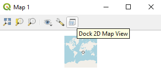
この機能は Nyall Dawson によって開発されました。
Feature: Add clear recently used crs button
The ability to remove "recently used" CRS information has been implemented in various ways, including:
Pressing the Del key while the list of recently used crs has focus remove the selected CRS
A column in the recent crs table with a button to clear individual CRS
A clear selected context menu action
A clear all recent CRS context menu action that will prompt the user for confirmation
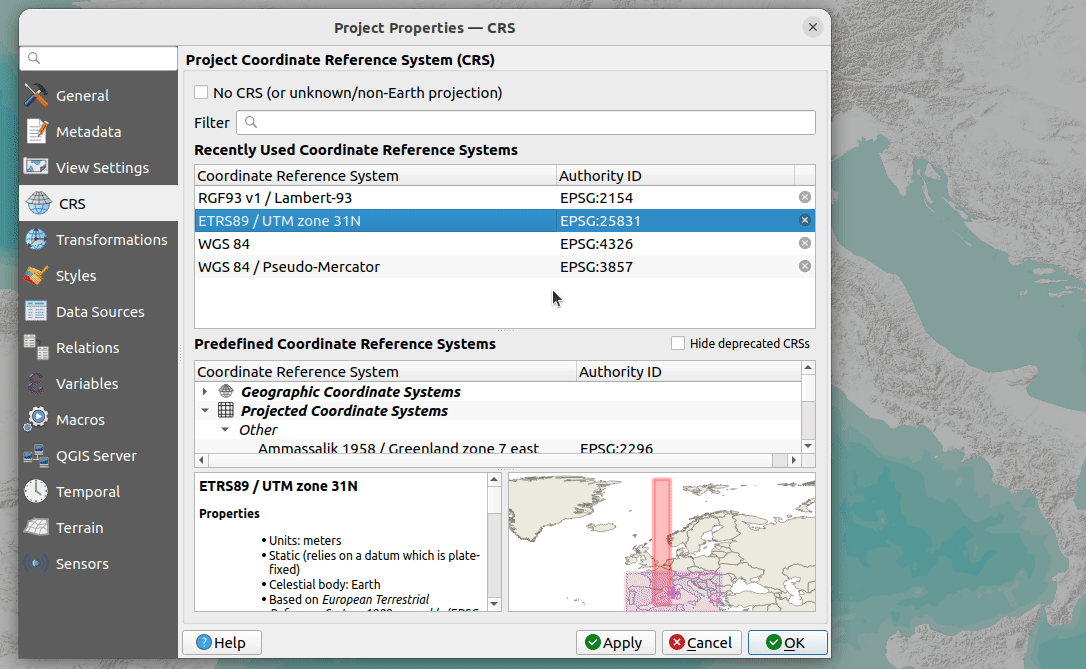
この機能は Yoann Quenach de Quivillic によって開発されました
Feature: Reverse wheel zoom
A setting is now available to reverse the zoom direction of the mouse wheel (scrolling forward zooms out)
This setting will affects wheel zooms in multiple contexts, including:
in the map canvas (
QgsMapCanvas)in the map overview (
QgsMapOverviewCanvas)in the layout view (
QgsLayoutView)in the layout map items when the "move item content" tool is active (
QgsLayoutViewToolMoveItemContent)in the Elevation profile canvas (
QgsElevationProfileCanvas)In the model editor graphic view (
QgsModelGraphicsView)
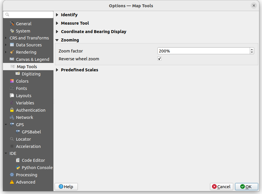
この機能は Yoann Quenach de Quivillic によって開発されました
Feature: Spatial bookmarks rotation
Map rotation can now be stored and applied in Spatial bookmarks, which includes a new context menu in the Spatial Bookmark Manager Panel.
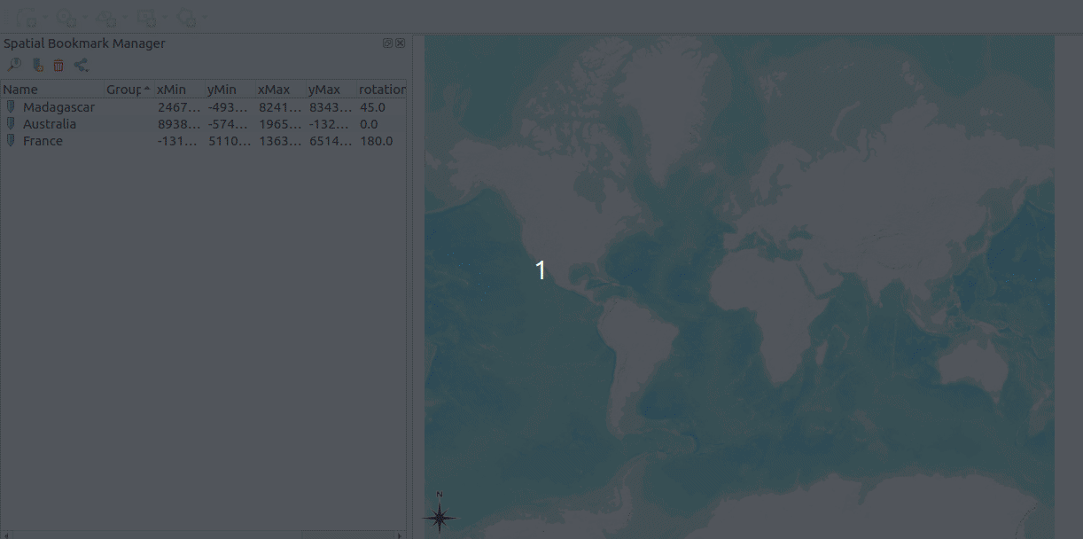
この機能は Yoann Quenach de Quivillic によって開発されました
注記
Feature: Annotation tool improvements
A number of improvements have been made to the behavior of annotation tools including:
Preventing the resizing of an annotation when the cursor is not actually over the frame
Add a context menu (when an annotation tool is activated) on annotation items
Drop the undocumented
toggleTextItemVisibilities(toggled Text annotations visibility with Ctrl+T)Improve the selection and resizing behavior, including improvements for handling overlapping annotations

この機能は Yoann Quenach de Quivillic によって開発されました
Feature: Annotation live preview
A "live update" checkbox in the annotation editors allows for on the fly review of rendered annotation content.
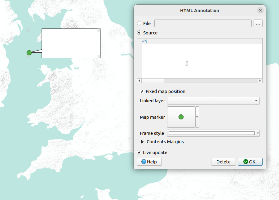
この機能は Yoann Quenach de Quivillic によって開発されました
三次元機能
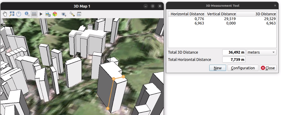
Feature: Improved 3d measure tool
The following improvements have been implemented to the measuring tool in 3d scenes:
Allows measuring on point cloud points
Display billboard circle markers on the 3d rubber band's vertices
Moving the mouse moves the rubber band's last vertex (although the measured results are not updated until user clicks)
Moving the camera does not remove current measurements
Allows using backspace and del keys to undo (remove last measurement)
Allows using Esc to clear measurements, matching the behavior of its 2d counterpart
Renders 3d rubberbands on top of other 3d entities so they don't get occluded
The object selection logic has also been refactored for more control, and the 3d identify tool was also enhanced to prevent interference with camera navigation as well as a bug fix for where the wrong FIDs were returned on specific cases.
This feature was funded by Point cloud processing and 3D data enhancements crowdfunding
この機能は Stefanos Natsis によって開発されました
点群
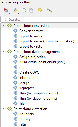
Feature: Native point cloud Processing provider
A new native processing provider has been provided for point cloud algorithms, in line with QEP 263.
Under the hood provider utilizes the pdal_wrench command line tool and currently supports the following algorithms:
Information: outputs a basic metadata of the point cloud (number of points, extent, crs, etc)
Convert format: convert point cloud to a different format, e.g. las to laz
Reproject: reproject point cloud to a different CRS
Fix projection: fix (assign) CRS of a point cloud file
Clip: clip point cloud by clipping polygon(s)
Merge: merge multiple point clouds in a single file
Tile: create tiles from input data
Thin: create a thinned version of the point cloud
Boundary: export vector layer containing point cloud boundaries
Density: export a raster file where each cell contains number of points that are in that cell's area
Export to raster: export point cloud data to a 2D raster grid
Export to vector: export point cloud data to a vector layer with 3D points
Export to raster (TIN): export point cloud data to a 2D raster grid using a triangulation of points
Filer: extract subset from the point cloud using PDAL expressions
As pdal_wrench requires PDAL >= 2.5.0, the new processing provider will be available only where the PDAL version requirement is satisfied.
This feature was funded by Point cloud processing and 3D data enhancements crowdfunding
この機能は Alexander Bruy によって開発されました
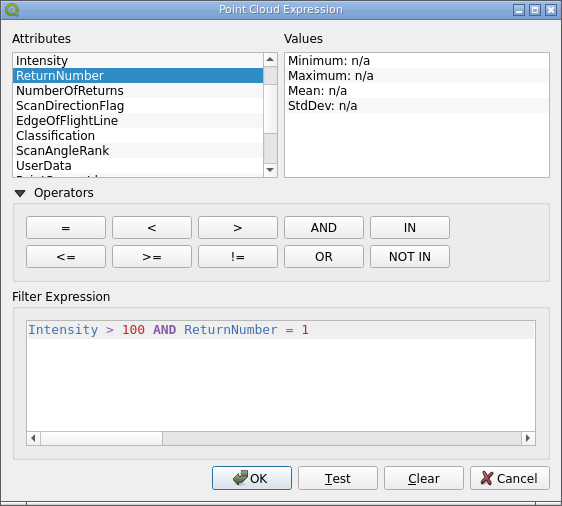
Feature: Point cloud expression builder for Processing framework
A new point cloud expression builder widget is available within the GUI to create filters for point clouds in a user friendly manner consistent with the existing QGIS Expression Builder interfaces.
Within the QGIS API, the QgsProcessingParameterExpression parameter has been extended with the types Qgis and PointCloud. If parameter has a PointCloud type, it will use the point cloud expression builder widget. To maintain backward compatibility, by default an expression parameter will use the Qgis expression type.
The QgsPointCloudExpression class was also extended with a new method to convert QGIS point cloud expressions to PDAL expressions.
Existing PDAL algorithms using expression filters have been updated to use expression parameters instead of strings.
This feature was funded by Point cloud processing and 3D data enhancements crowdfunding
この機能は Alexander Bruy によって開発されました
Feature: Add filtering by rectangle and expression to PDAL algorithms
Added the option to filter input point cloud by rectangle (extent) and expression in the following PDAL algorithms:
boundary
clip
密度
export to raster (normal and TIN variants)
export to vector
merge
thin
This allows the processing of only a subset of points from the input file(s), without the need to performing an intermediate filtering step or generating temporary files.
For these who need only filtering there is also a separate Filter algorithm capable of filtering either by extent, by expression or by their combination.
This feature was funded by Point cloud processing and 3D data enhancements crowdfunding
この機能は Alexander Bruy によって開発されました
Feature: New parameter type for point cloud attribute
Useful for point cloud algorithms involving attributes, like exporting specific attribute values as raster or filtering point clouds.
This also deprecates parameterAsFields API call, and parameterAsStrings should be used both for fields and point cloud attributes instead.
This feature was funded by Point cloud processing and 3D data enhancements crowdfunding
この機能は Alexander Bruy によって開発されました
Feature: Display virtual point clouds (VPC) in 3D views
Virtual point clouds can be rendered within 3d views. For performance management, a sub index threshold is specified so that the view will render the chunked entity of the point cloud only when appropriate and will instead render the bounding region of a particular sub index when the threshold criteria is not met.
This feature was funded by Point cloud processing and 3D data enhancements crowdfunding
この機能は Stefanos Natsis によって開発されました
Feature: Virtual point clouds (VPC)
A new data provider is available for Virtual Point Cloud (VPC) files created by the pdal_wrench utility and the Build virtual point cloud (VPC) tool in the newly introduced Native point cloud Processing provider.
The VPC file is handled as a single layer in QGIS and may contain a large number of point cloud files whose indexes are lazy loaded when the canvas is zoomed in enough. An extent renderer is used for the individual indexes while their extent fits the canvas' width and the user defined renderer is only used when zoomed in further.
A Virtual Point Cloud is a JSON container file with a .vpc extension, referring to other files/URLs that contain the actual point cloud data. This is a concept similar to virtual rasters (VRTs) in GDAL. The JSON content is actually a STAC API ItemCollection. See VPC specification for more details.
This feature was funded by Point cloud processing and 3D data enhancements crowdfunding
この機能は Stefanos Natsis によって開発されました
印刷レイアウト
Feature: Hyperlink support for HTML-enabled label exports
QGIS labels which contain HTML content will now support embedding functional hyperlinks in relevant layouts exports, such as PDFs.
この機能は Kanton Schaffhausen によって資金提供されました
この機能は、Mathieu Pellerin によって開発されました
Feature: Support filtering layout legends by multiple linked map items
Instead of limiting layout legend filtering to a single linked map, this change permits legends to be filtered instead by multiple linked maps. It is designed to accommodate the use case where a layout has multiple maps, potentially at different scales and showing different extents, and a single legend is required which includes all symbols visible across all the maps.
The UX has been designed to avoid changing the current user workflows, in that legends will still be linked to a single main map item. This map is used when determining the scale (and other map dependent properties) at which to render the legend's symbols. Checking the "Only show items inside linked maps" option will still automatically filter the legend by the content of the main linked maps. However, there's a new "..." options button next to the "Only show items inside linked maps" checkbox which allows users to select also other maps from their layout to consider when determining visible items:
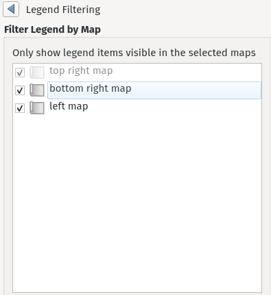
この機能は City of Canning によって資金提供されました
この機能は Nyall Dawson によって開発されました。
計算式
Feature: Add ltrim/rtrim functions
Allows trimming spaces or other characters from just the start or end of strings
この機能は Nyall Dawson によって開発されました。
デジタイズ
Feature: Field value list in merge feature dialog
When merging features, users may now select from a list of available values from the selected features, rather than manually capturing a manual value for a field.
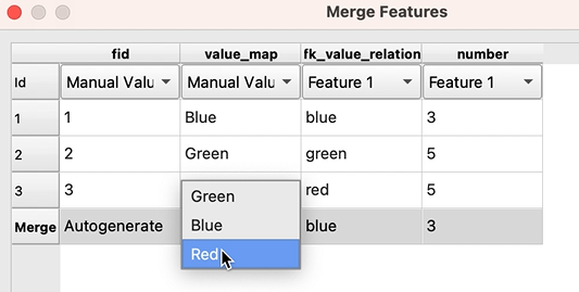
この機能は Denis Rouzaud によって開発されました
Feature: Common angle option extensions for advanced digitizing
The advanced digitizing options for common angles have been extended with the following functionalities:
New common angles for 0.1°, 0.5°, and 1.0°
A new option has been added to show current common angle in the floater context widget
New 'N' 'SHIFT+N' keyboard shortcuts are available to cycle through the common angle options
This feature was funded by ChartWorld International
この機能は Alessandro Pasotti によって開発されました
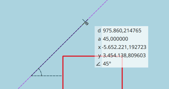
Feature: Floater settings and bearing information for advanced digitizing
A new configuration setting for the advanced digitizing tool allows users to toggle the display of the "floater" contextual menu which follows the cursor during digitizing. Additional options are included for adding information to the floater panel, such as the display of bearing and azimuth information.
This feature was funded by ChartWorld International
この機能は Alessandro Pasotti によって開発されました
属性テーブル
データ管理
Feature: Allow a range of cells to be copied from SQL results window
Allows selection of a range of cells to copy to clipboard. Results are copied as both plain text and html, so can be pasted easily into spreadsheet apps/etc as tables
この機能は Nyall Dawson によって開発されました。
Feature: Modified New field dialog behavior and alias support
When creating new fields, the 'Comment' option is now only exposed for datasources which support editing comments (preventing QGIS from silently discarding the information).
This also adds support for setting field aliases within the new field dialog, and extends field comments and aliases for supported OGR formats.
この機能は Nyall Dawson によって開発されました。
Feature: Add DistanceUnit value for inches
Inches are now included as valid map units within QGIS.
この機能は Nyall Dawson によって開発されました。
Feature: Record split policy selection in form dialog
A new "field split policy" choice item is exposed in the layer properties form dialog. That allows users to easily determine the current policy for splitting a field and change as required.
The following policies have been provided:
duplicate values
remove values
use default value
use ratio of geometries
この機能は Nyall Dawson によって開発されました。
フォームとウィジェット
Feature: Add control over horizontal / vertical stretch for attribute form widgets
This functionality exposes two new "size" options for edit form widgets, allowing control over the horizontal and vertical stretch factors for the widget. By setting a horizontal or vertical stretch, users can control how edit widgets will relatively resize when resizing an attribute form.
For example, a user can set a higher horizontal stretch value for widgets which should "grab" more of the available horizontal space, such as for those widgets which are expected to have longer values. Similarly, the vertical stretch setting (available for select widget types) will control how widgets grow vertically when resizing forms, relative to the form dialog.
Together these options give more control to users over the exact layout and sizing of their attribute forms.
By default, the stretch values are set to "Default" which is the same as the behavior exhibited in previous versions of QGIS.
この機能は Nyall Dawson によって開発されました。
Feature: Add new attribute form container type "Row"
This container always lays out child widgets in a horizontal row, where the number of columns is automatically determined by the number of child widgets.
It's useful for creation of compact forms, where no space will be wasted by assigning extraneous horizontal width to widgets where the expected values will always be short.
Eg: creating 3 rows with 3, 2, 1 child widgets respectively results in the layout:
Attr 1: [...] Attr 2: [...] Attr 3: [...]
Attr 4: [..........] Attr 5: [..........]
Attr 6: [...............................]
Without the option of row containers then the all horizontal rows will have the same number of columns, eg:
Attr 1: [...] Attr 2: [...] Attr 3: [...]
Attr 4: [...] Attr 5: [...] Attr 6: [...]
(leaving insufficient horizontal length for attributes 4-6), or
Attr 1: [..........] Attr 2: [..........]
Attr 2: [..........] Attr 3: [..........]
Attr 4: [..........] Attr 5: [..........]
Attr 6: [..........]
(resulting in wasted horizontal space next to attribute 6, and an extra row taking up vertical space)
この機能は NIWA によって資金提供されました
この機能は Nyall Dawson によって開発されました。
プロセシング
Feature: Download vector tiles algorithm
A new Processing algorithm has been added which enables the downloading of vector tiles from a remote server. This functionality includes vector tile support for the map layer parameter, as well as a new vector tile destination parameter for Processing algorithms. The output MBTiles format files can also be automatically added to the canvas after processing.
This feature was funded by Mergin Maps
この機能は Alexander Bruy によって開発されました
Feature: Allow configuration of the order of outputs created by a model
A new "Reorder Output Layers" action to the model designer menu has been added which allows model creators to set a specific order which the outputs from their model must use when loading the results into a project. This gives the model creator a means of ensuring that layers are logically ordered on the canvas when running a model, such as placing a vector layer output over a raster layer output, or a point layer over a polygon layer.
The model creator can also set an optional "Group name" for the outputs for automatically grouping outputs within the layer tree using a new group name or by adding them to an existing group.
This feature was funded by QGIS User Group Germany
この機能は Nyall Dawson によって開発されました。
Feature: Algorithm to create COPC files for input point clouds
A new algorithm adds the "Create COPC" option to the PDAL provider for generating Cloud Optimized Point Clouds. The algorithm creates a COPC file for each input point cloud file and can be useful for indexing files before using them in QGIS, or when building a VPC.
This feature was funded by Point cloud processing and 3D data enhancements crowdfunding
この機能は Alexander Bruy によって開発されました
Feature: Add invert selection tool on refactor fields processing tool
A new button has been added to the field management interface of the refactor fields processing tool button which allows users to invert the selection. This allows for more efficient management of fields such as enabling bulk field deletes.
This feature was added during the QGIS Contributor Meeting 2023, s-hertogenbosch
This feature was funded by camptocamp
この機能は、Ismail Sunni によって開発されました
Feature: Support field comments and aliases in processing algorithms
This adds support for handling field comments and aliases in the processing "add field to attributes table" and "refactor fields" algorithms. Additionally, it ensures that field comments and aliases are copied from source layers to destination layers when present.
If the output layers do not support comments/ aliases then user-friendly warnings are shown in the processing log advising users of the limitation.
この機能は Nyall Dawson によって開発されました。
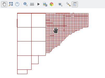
Feature: Build virtual point cloud (VPC) algorithm
The new algorithm allows user to build virtual point cloud (VPC) files that reference multiple existing point cloud datasets. This allows then visualization and processing of many point cloud files as a single layer in QGIS.
Additional options are available for the "Build VPC" Processing algorithm, which provide the following utilities for building Virtual Point Clouds:
calculate statistics from input data
calculate exact boundaries from input data
build an overview point cloud
This feature was funded by Point cloud processing and 3D data enhancements crowdfunding
この機能は Alexander Bruy によって開発されました
Feature: Thread management in algorithm settings
A handy new environment configuration setting has been created for the configuration of the number of threads an algorithm should use when an algorithm is capable of using several cores, such as TauDEM or PDAL.
This functionality has been applied to the PDAL and TileXYZ algorithms.
この機能は Alexander Bruy によって開発されました
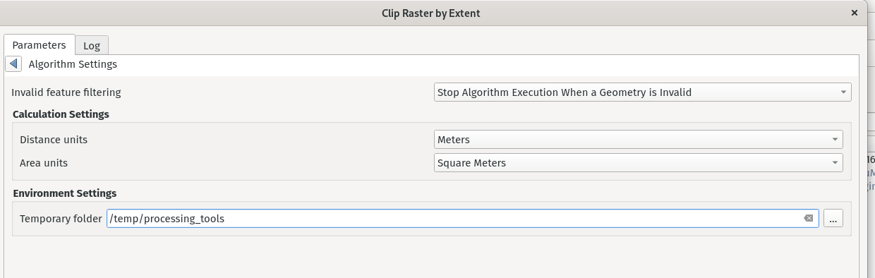
Feature: Allow temporary folder to be temporarily changed through the algorithm settings panel
Individual processing algorithms may now include an environment setting to specify a custom temporary folder which overwrites the configured temporary file path. This is useful in situations where a particular tool may use a lot of temporary disk space and a dedicated location or scratch disk is required, or when a particular operation requires performance enhancements offered by a particular disk or path.
この機能は Nyall Dawson によって開発されました。
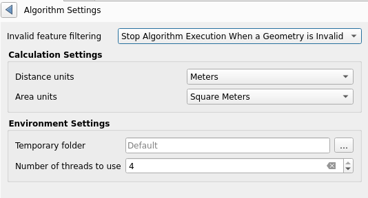
Feature: Allow processing dialog to override default processing context settings
A new "Algorithm Settings" action has been added to the Advanced button of the processing algorithms interface. Selecting it shows a panel which allows users to control general processing settings which apply to a particular instance of the algorithm execution. It's intended to be a place where a user can override their global processing settings on an ad-hoc basis without having to change their usual default settings.
Includes settings for:
invalid geometry handling (Unlike the existing per-parameter setting override for this, setting the handling method here will apply to ALL inputs for the algorithm)
distance unit and area units to use for distance/area measurements
この機能は Nyall Dawson によって開発されました。
Feature: Additional parameters for gdal2xyz algorithm
The gdal2xyz processing algorithm from the GDAL processing provider now includes parameters for skipnodata and src, and dstnodata.
This feature was developed by Luke Pinner
Feature: Add "Keep disjoint results separate" option to buffer algorithm
If checked, then any disjoint parts in the buffer results will be output as separate single-part features. This setting is designed to expose a similar functionality as is available for the 'dissolve' algorithm.
この機能は City of Canning によって資金提供されました
この機能は Nyall Dawson によって開発されました。
Feature: Allow filter expressions to be set for vector sources
This change adds a new "feature filter" option alongside the existing feature limit and invalid geometry handling options available for all vector inputs to processing layers.
It allows users to enter an expression to subset the layer dynamically when running the tool, avoiding the need for separate steps to set layer filters or create layer subsets.
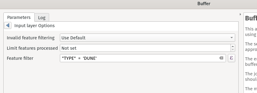
この機能は City of Canning によって資金提供されました
この機能は Nyall Dawson によって開発されました。
Feature: Support *.HEIC format images in Processing "Import Photos" algorithm
The Import Photos algorithm now allows importing *.heic images with GDAL's HEIF image support.
This feature was developed by Chris Shucksmith
アプリケーションとプロジェクトのオプション
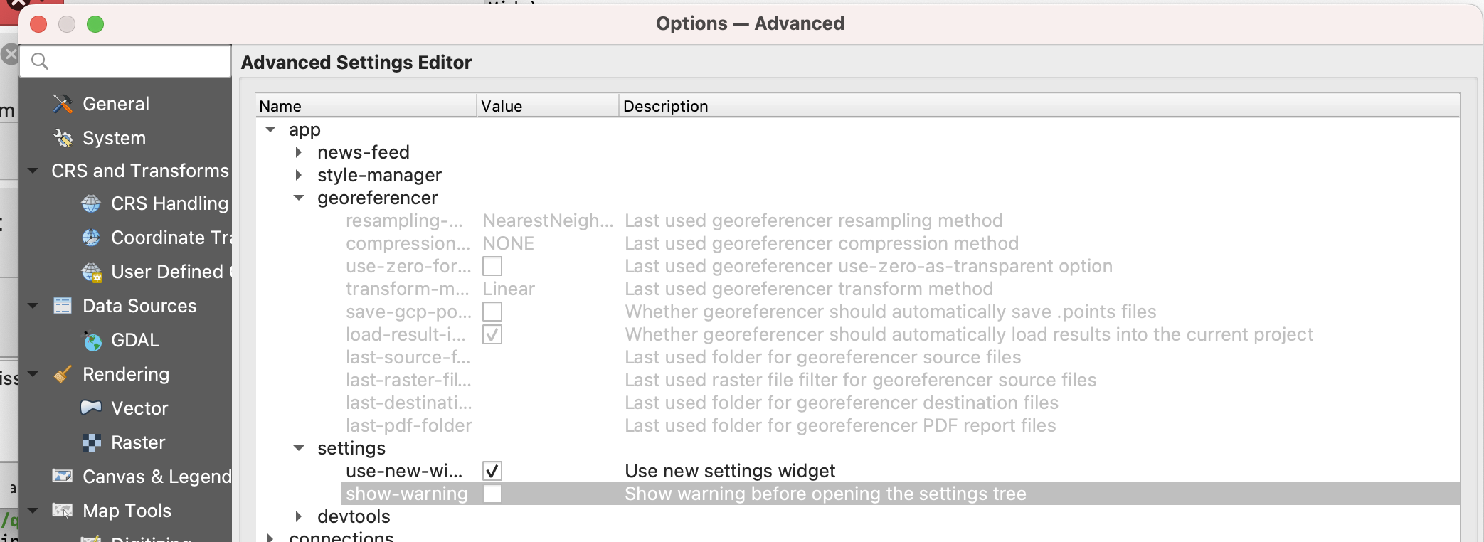
Feature: Settings editor updates
The interface for settings editors have seen a major overhaul and the advanced settings interface has the following user facing changes:
A choice of using the old or the new settings widget, which is remembered
A "hidden" setting allows to bypass the warning before showing the settings tree
Settings have dedicated editors (spin box, checkbox, colorbutton, etc.)
The modification of settings is now only executed when apply is pressed
Current settings are displayed in italic, whereas settings to which changes will be applied are displayed in red
In addition, the settings API has undergone significant changes including:
Removal of the QgsSettingsEntryByValue class, using the by reference only
The old QgsSettingsTreeWidget has been renamed to QgsSettingsTreeWidgetOld (in app)
New API classes introduced include:
QgsSettingsTreeWidget and QgsSettingsTreeModel: tree widget + model to show and edit the settings
QgsSettingsEditorWidgetWrapper (pure virtual): a base wrapper class to create and handle a setting editor widget
QgsSettingsEditorWidgetWrapperTemplate (pure virtual): the base class for the wrapper of settings declared in C++ API (using typed methods)
Classes for settings editors: QgsSettingsStringEditorWidgetWrapper, etc.
QgsSettingsEditorWidgetRegistry: a registry of the setting editor wrappers
この機能は Denis Rouzaud によって開発されました
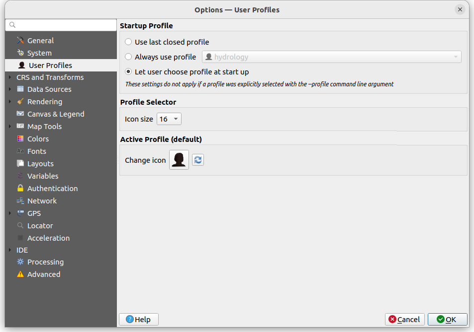
Feature: User profile selector
In previous versions of QGIS, when QGIS Desktop was closed the current profile would be saved in the profiles.ini configuration file, so the default profile was the profile used in the last instance of QGIS that was closed.
A new User selection policy feature allows users to select how default profiles are defined, in accordance with the following three options:
Last Profile: The legacy mode which follows previous version behavior. This uses the last closed profile when opening a new instance of QGIS.
Default Profile: Manually define a default profile among the existing profile that will always be used by default (without using a command line flag or electing a profile from within the QGIS UI)
Let user choose at startup
When "Let user choose" is selected, if there are 2 or more profiles, a selection dialog is displayed before the SplashScreen which will allow the user to choose which profile to use or to create a new profile which will be loaded automatically.
Regardless of the selected policy, if only one profile exists it will be used, and if no profile exist, the default profile will be created and used.
User profile icons are also provided to allow users to visually differentiate between their active profiles.
この機能は Yoann Quenach de Quivillic によって開発されました
Profile Plots
Feature: Distance unit selection for elevation profiles
Users may now choose from a selection of distance units to override the default (Canvas CRS map units) for elevation profiles in both the interactive elevation profiles (via the settings toolbar button) and for layout elevation profiles.
In layout profiles, there is an additional option which controls where the distance unit suffixes should be placed. The following options are available to manage the display of unit suffixes:
hide the suffixes
display for all values
display for the first value
display for the last value
display for both the first and last values.
Note that it is currently not possible to expose unit selection for the vertical axis, as this is currently dimensionless and will require the development of vertical CRS handling in QGIS as outlined in QEP 267.
This feature was funded by Point cloud processing and 3D data enhancements crowdfunding
この機能は Nyall Dawson によって開発されました。
Feature: Export elevation profiles
A new item has been added to the elevation profile toolbar, which includes various options for exporting elevation profiles.
Profile plots can now be exported as:
3D Features: exports the profile line as 3d cross sections, with z values taken from the elevation slices
2D Profile: exports the profile as a distance vs elevation chart (i.e. as shown in the elevation profile widget)
Distance/Elevation Table: exports sample distance vs elevation values as a table
The results can be saved as DXF files, CSV files, or any of the standard writable vector spatial formats shapefile geopackages.
This feature was funded by Point cloud processing and 3D data enhancements crowdfunding
この機能は Nyall Dawson によって開発されました。
Feature: Add layers to elevation profiles
An explicit "Add Layers" button has been added to the elevation profile dock. This provides a user-friendly why of adding new layers to a plot - clicking it will show a filtered list of possible layers which can be added to the plot, but which currently aren't in the plot (i.e it will include all raster layers from the project which aren't marked as having elevation data). Selecting layers will cause them to automatically be marked as having elevation data and immediately added to the plot.
Layers can now be added to elevation plots via drag and drop from the layer tree. Unfortunately, users will have to explicitly hold the "Ctrl" key while dragging in order to force the copy action due to upstream library limitations.
This feature was funded by Point cloud processing and 3D data enhancements crowdfunding
この機能は Nyall Dawson によって開発されました。
Feature: Add "Fill Above" mode for elevation profile drawing
The new fill above drawing mode for profile plots also includes additional options to limit the extent of "fill above" and "fill below" elevation ranges for a layer.
この機能は Nyall Dawson によって開発されました。
Feature: Add option to lock the horizontal/ vertical scale to matching scales
When activated, this option ensures that the horizontal and vertical scales are always kept equal. For instance, a 45 degree slope will always appear as a 45 degree slope in the profile.
This feature was funded by Point cloud processing and 3D data enhancements crowdfunding
この機能は Nyall Dawson によって開発されました。
センサ
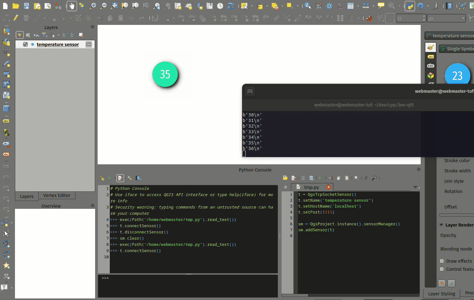
Feature: Core sensors framework
A core sensors framework provides a sensor types registry, a sensor manager, and three simple QIODevice-based sensor types as follows:
TCP socket
UDP socket
Serial port
A sensor manager is attached to project instances that allows users to register sensors within their project files. Contrary to other inputs such as a positioning device, sensors are considered to be much more project-specific data inputs. The big advantage of project-based sensors is that it makes those much more portable and easier to share across users.
A new sensor_data() function is added to the project scope which is available using expressions, that returns the latest captured sensor data values for a specific sensor name. An optional expiration (in milliseconds) parameter allows for expressions that will reject a specific sensor value is older that the provided expiration value.
This feature was funded by Sevenson Environmental Services
この機能は、Mathieu Pellerin によって開発されました
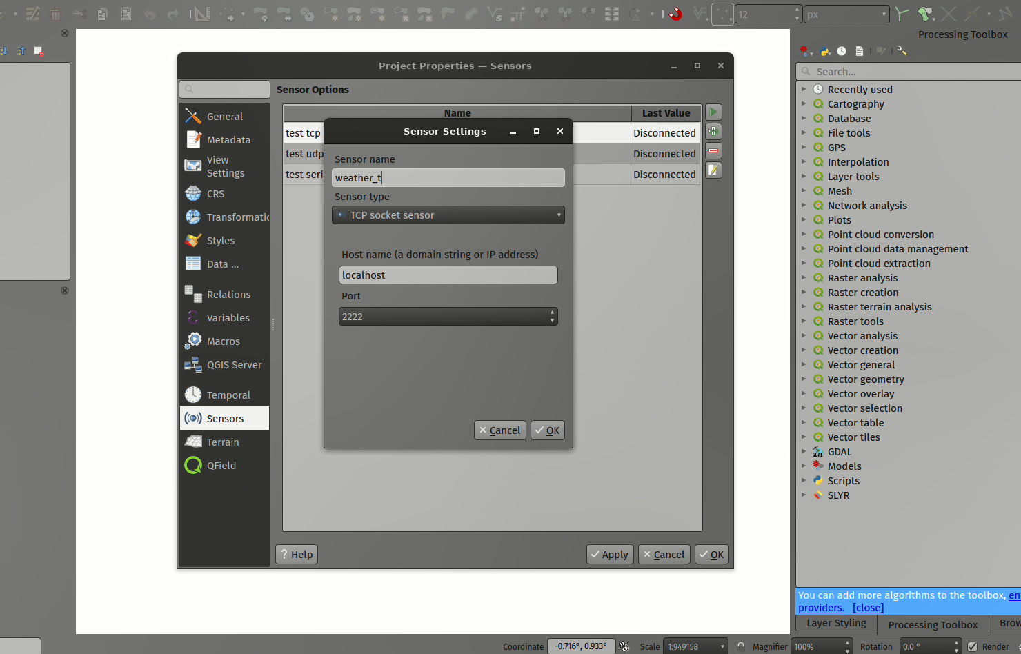
Feature: Sensors GUI registry and configuration widgets
Configuration widgets are provided for the TCP, UDP, and serial port sensor types which will allow users to configure, add, and remove sensors within the project properties dialog's sensors panel.
The implementation includes a sensor GUI registry to easily allow for additional python sensors to be created and shipped as plugins.
This feature was funded by Sevenson Environmental Services
この機能は、Mathieu Pellerin によって開発されました
Feature: Sensor options panel within the project properties dialog
A sensor table widget is provided that displays registered sensors within a project, along with with actions to connect and disconnect from sensors. The table is accessible via a new sensors panel in the project properties dialog.
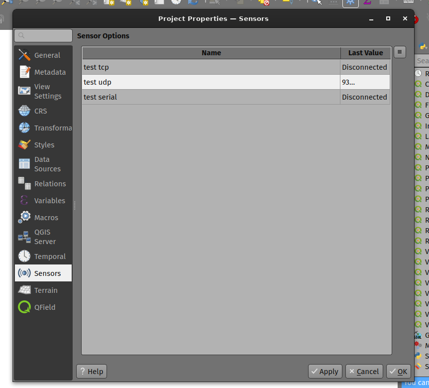
This feature was funded by Sevenson Environmental Services
この機能は、Mathieu Pellerin によって開発されました
ブラウザ
Feature: Set field comments in browser
When supported by providers, a new browser context menu action for fields allows for users to set/change the field's comments in the datasource.
Currently supported for OGR formats with field comment capabilities such as GPKG, ESRI File Geodatabase, NetCDF, or Geoparquet, as well as PostgreSQL data sources.
この機能は Nyall Dawson によって開発されました。
Feature: Set field aliases in browser
When supported by providers, a new browser context menu action for fields allows for users to set/change the field's alias in the datasource.
Currently supported for OGR formats with field comment capabilities such as GPKG, ESRI File Geodatabase, NetCDF, or Geoparquet.
この機能は Nyall Dawson によって開発されました。
データプロバイダ
Feature: Load layers in parallel threads when opening project
QGIS will now load supported layers in parallel when loading a project, significantly improving project load times in certain instances such as when a project includes numerous remote layers.
To load a layer on a parallel worker thread, the layer data provider must support parallel loading (currently GDAL and PostgreSQL providers).
A new advanced setting is available to deactivate this behavior when necessary.
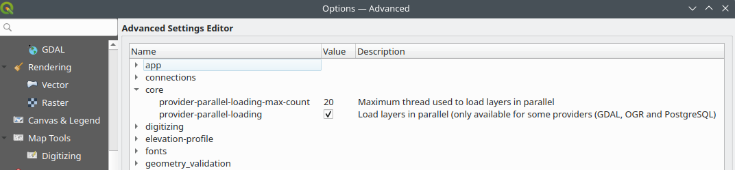
This feature was funded by KoBold Metals
この機能は Vincent Cloarec によって開発されました
Feature: Implements server-side filtering using Part 1 or Part 3
The WFS/ OGC API for Features (OAPIF) data provider has been extended to support enhanced filtering criteria in line with open standards.
New functionalities include:
Support for filtering on feature properties (OGC API Features Part 1 - /rec/core/fc-filters). This uses the /api endpoint to get the list of queryable items.
Support for filtering based on OGC API Features Part 3 - CQL2-text
Pass selected CRS to query builder UI
Implement a getFeature() expression translation
For the CQL2text compatibility, the server /conformance implementation is required to declare at least the following data:
http://www.opengis.net/spec/ogcapi-features-3/1.0/conf/filter
http://www.opengis.net/spec/ogcapi-features-3/1.0/conf/features-filter
The /collections/{collid}/queryables endpoint is requested to get the queryable properties.
Additional conformance classes for advanced filtering include the following items:
http://www.opengis.net/spec/cql2/1.0/conf/advanced-comparison-operators: for IN, BETWEEN, LIKE
http://www.opengis.net/spec/cql2/1.0/conf/case-insensitive-comparison: for ILIKE
http://www.opengis.net/spec/cql2/1.0/conf/basic-spatial-operators: for
intersects(geomcolumn, geomFromWkt('POINT(x y)'))andbbox_intersects(geomcolumn, geomFromWkt('WKT LITERAL'))
This feature was developed by Even Rouault
Feature: Expose option to load vector tile sources from files in Data Source Manager
The Vector Tile tab now includes choices for selecting from a "Service" (the existing, connection based approach for adding vector tiles from online sources) or "File" (a new option which allows directly adding a data source using VTPK or MBTiles vector tile files).
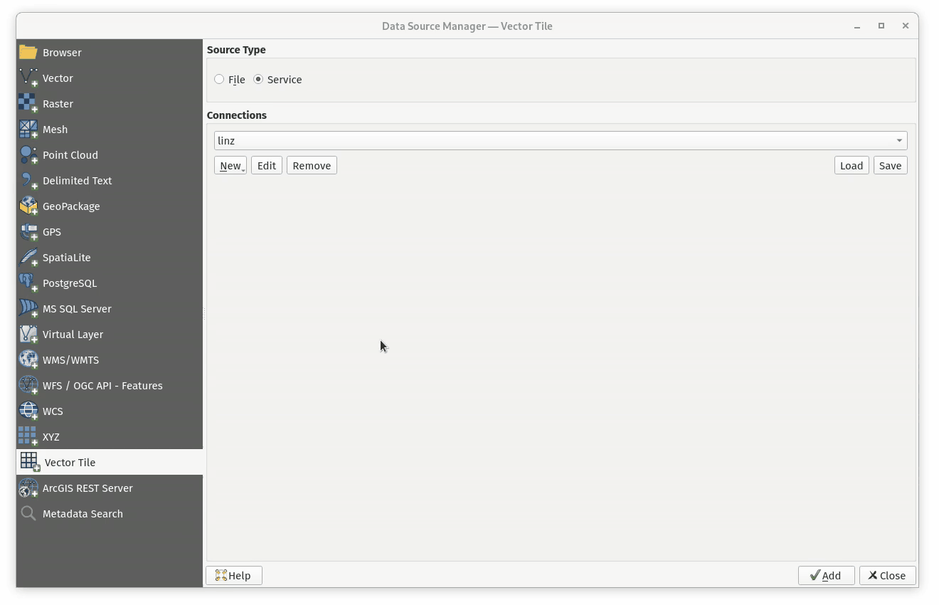
This feature was funded by Landesamt für Vermessung und Geoinformation, Feldkirch, Austria
この機能は Nyall Dawson によって開発されました。
Feature: Additional user controlled vector tile properties
Vector tile data sources now support user defined controls for layer opacity and blending modes.
Additionally, it adds the standard "Source" and "Rendering" tabs to the vector tile layer properties dialog. The Rendering tab contains the layer's scale based visibility (just like for other layer types), and the source tab contains the layer name, crs override and provider-specific source controls.
Source widgets are also for the VTPK and MBTiles vector tile providers, allowing control over the source vtpk/mbtiles file path.
この機能は Nyall Dawson によって開発されました。
Feature: Fix broken layer support for vtpk/mbtile vector tile layers, show vtpk files in browser
Vector tile layers now expose all the required API items for supporting broken layer handling and discovery, making their behavior consistent with other layer types. Additionally, by implementing the modern provider metadata APIs for the VTPK provider we ensure that VTPK files are shown in the browser panel for easy discovery.
This feature was funded by Landesamt für Vermessung und Geoinformation, Feldkirch, Austria
この機能は Nyall Dawson によって開発されました。
QGISサーバー
Feature: PDF format options for WMS GetPrint
The FORMAT_OPTIONS parameter in QGIS Server can now also be used to pass format options for PDF format to WMS GetPrint.
This allows more control in GetPrint requests when generating GeoPDF outputs, such as Georeference or Geometry Simplification settings.
この機能は mhugent によって開発されました
Feature: Configurable capabilities cache size
The QGIS Server GetCapabilities request cache size can now be configured with the QGIS_SERVER_CAPABILITIES_CACHE_SIZE parameter, which uses an integer input specifying the number of requests to cache. A notice of "Removed cached WMS capabilities document" will be logged when all slots are taken and a cached document is dropped.
This feature was developed by Jürgen Fischer
Feature: Add display name in GetFeatureInfo response
A new WITH_DISPLAY_NAME parameter will add the display name in the GetFeatureInfo response if needed, similar to the existing WITH_MAPTIP parameter.
This feature was funded by 3liz.com
この機能は Étienne Trimaille によって開発されました
Feature: OGC API - Features: Add full pagination for collection items HTML page
To make browsing the features more user friendly and provide more information, the following was implemented and added to the HTML template:
full pagination which shows always the total number of pages
configurable pagesize via dropdown
number of matching items
number of returned items
pagesize/pagination controls also at the bottom of the page
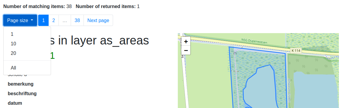
この機能は Björn Hinkeldey によって開発されました
プログラム可能
Feature: Python console help improvements
A special ? command has been added to the python console which displays a useful help message, identifies some key variables, and provides helper functions for improving the developer experience within QGIS Desktop.
The _pyqgis and _api helper functions will take a parameter (an instance or class), and will display the matching object page from the QGIS or Qt documentation.
この機能は Yoann Quenach de Quivillic によって開発されました
Feature: Run shell commands from the Python Console
The QGIS Python ConsoleMimics IPython behavior to run system commands.
Run any command that works at the command-line with the syntax
!<cmd>. The console will start a subprocess, and forward its output to the Python Console Output.While the subprocess is running, the Python Console Input switch to STDIN mode and forwards entered character to the child process. This make it possible to send confirmation when the child program ask for it.
This provides easy access to commands such as pip for the simple installation and removal of dependencies directly within the QGIS project context
When the Console is in STDIN mode, pressing Ctrl+C will kill the subprocess.
Affect the result of a command to a variable with the syntax
var = !cmd
この機能は Yoann Quenach de Quivillic によって開発されました
Feature: Reformat code action for code editors
A "format code" action has been added to the Python Console Editor which allows for the automated linting/ pretty printing of code in line with the capabilities of modern code editors.
Additional configuration settings for this action include:
Format on save: if enabled, formatting is applied just before saving the script
Sort imports: Sort import statements using isort
Max line length: Control how the formatter will wrap the lines, and controls the editor ruler
The Formatter options allow for a selection between the autopep8 or black linting tools and provide the following additional options:
Level (autopep8 only) See Autopep8 aggressiveness level
Normalize quotes (black only): Replace all single quotes with double quotes if possible
Sorting operations are provided using isort, which will allow for sorting import statements in three different groups:
standard library imports (re, os, sys, json, ...)
third-party modules (PyQt5, pandas, dateutil, ...)
first-party modules (qgis, processing, ...)
These operations will facilitate consistent development in line with industry best practices and improve code quality, consistency, readability, and operational efficiency (especially when coupled with version control systems).
この機能は Yoann Quenach de Quivillic によって開発されました
Feature: Toggle Python console to full main window
Adds the same toggle button 3d map canvases and attribute tables to make it super-easy to switch the Python console to a full main window or back to a docked widget.
この機能は Nyall Dawson によって開発されました。
Feature: Reformat HTML Code in Code Editors
Editors using the QgsCodeEditorHTML class will be able to use the code reformatting functionality to pretty print HTML data within QGIS. Note that this functionality will require the BeautifulSoup4 or lxml libraries to be installed within the python environment to parse the XML/ HTML data.
この機能は Yoann Quenach de Quivillic によって開発されました
注目すべき修正
Feature: Bug fixes by Even Rouault (Spatialys)
バグの表題 |
URL issues (Github, if reported) |
URL Commit (Github) |
3.28 backport commit (GitHub) |
|---|---|---|---|
GeoJSON IDs are barely supported (only reading string IDs is supported) |
Just analysis - fix out of scope |
unreported - [cleanup] QgsOgrFeatureIterator(): remove (hopefully!) useless code in subset string case |
|
"Order by" memory leak |
N/A |
||
Browser very slow when opening directory containing several GDB |
Doesn't build with armv7 on openSUSE Tumbleweed |
||
Add .pgwx as potential world file types for georeferenced png |
N/A - GDAL fix |
||
Assertion failed when filtering a GeoParquet layer |
N/A - GDAL fix |
||
Given URL parameters do not persist for WFS OGC API - Features connection |
tried to reproduce - too complicated |
Field domain created incorrectly |
|
Field domain created incorrectly |
|||
Longer opening time of GPKG file in newer versions |
TODO |
この機能は QGIS.ORG (through donations and sustaining memberships) によって資金提供されました
This feature was developed by Even Rouault (Spatialys)
Feature: Bug fixes by Sandro Santilli (strk)
バグの表題 |
URL issues (Github, if reported) |
URL Commit (Github) |
3.28 backport commit (GitHub) |
|---|---|---|---|
QGIS offset line shows perpendicular tags issue |
|||
strange behaviour of single sided buffer algorithm |
N/A - GEOS fix |
この機能は QGIS.ORG (through donations and sustaining memberships) によって資金提供されました
This feature was developed by Sandro Santilli (strk)
Feature: Bug fixes by Alessandro Pasotti (itOpen / qcooperative)
バグの表題 |
URL issues (Github, if reported) |
URL Commit (Github) |
3.28 backport commit (GitHub) |
|---|---|---|---|
Legend filter expression has an incomplete context |
queued |
||
LineString showing offset in CRS 3857 when using Vertex Tool and "Clip Features to Canvas Extent" is enabled |
queued |
||
Qgis Server WMTS returns wrong WGS84BoundingBox for the layer |
複製できない |
Form not showing (randomly) values except when triggering "Editing Mode" |
|
OGC API Features ignores "X-Qgis-Service-Url" header |
won't fix |
Fixed legend size is not respected when exporting a layout |
|
Snap to random vertices after splitting features |
複製できない |
Cartographic label placement with "Distance Offset: From Symbol Bounds" shows offset for MultiPoint features |
|
Layers rendered as a group seem to bypass the "Lock Layers" option in my print composer. |
queued but PR is still unreviewed |
||
Map Layout composer - Legend item expression not displaying correctly |
not worth it, not critical |
||
opacities parameter doesn't apply to labels in GetMap requests |
queued but PR is still unreviewed |
||
The list in "Link to existing child features" does not help in selecting the right child features |
won't fix |
Object Snap on Lines does not work for arc-elements |
|
Attribute form widgets are not disabled when "Editable" state is data-defined and layer is not in edit mode |
N/A |
この機能は QGIS.ORG (through donations and sustaining memberships) によって資金提供されました
This feature was developed by Alessandro Pasotti (itOpen / qcooperative)
Feature: Bug fixes by Alex Bruy (LutraConsulting)
バグの表題 |
URL issues (Github, if reported) |
URL Commit (Github) |
3.28 backport commit (GitHub) |
|---|---|---|---|
[Expressions]: missing "//" operator help |
|||
Resample or rescale of a raster image cannot be found in a menu item or in the processing toolbox |
Error produced by closing algorithm dialogs: RuntimeError: wrapped C/C++ object of type QgsMapToolCapture has been deleted |
||
Model designer export as/run as python didn't catch newline in algorithm comments |
|||
Add' button for adding XYZ layer through Data Source Manager remains disabled |
|||
Output of Algorithm jumps top left when moving |
|||
Name column always shows alias instead of field name in refactor fields algorithm |
|||
Sentinel 1 data set not working properly |
Not a bug, wrong selection of data format for huge and complex geometries |
Generate XYZ tiles (MBTiles) - error when run |
この機能は QGIS.ORG (through donations and sustaining memberships) によって資金提供されました
This feature was developed by Alex Bruy (LutraConsulting)
機能: Julien Cabiecesによるバグ修正
バグの表題 |
URL issues (Github, if reported) |
URL Commit (Github) |
3.28 backport commit (GitHub) |
|---|---|---|---|
QgsRasterIterator.readNextRasterPart() has a memory leak |
|||
Options for some values in Processing are not saved after close window |
いいえ |
||
Unable to import layer from Postgis view or materialized view , if it has no no primary key |
バグではない |
||
Unwanted vertices when tracing |
|||
Topology checker does not highlight all overlap errors in the canvas |
|||
Unable to enter interval size for fixed Interval in Graduated Renderer |
|||
Vector Tile Layers do not clip to layout map frame when mask enabled |
Qt upstream issue |
||
Splitfeatures function |
この機能は QGIS.ORG (through donations and sustaining memberships) によって資金提供されました
This feature was developed by Julien Cabieces (Oslandia)
Feature: Bug fixes by Jean Felder (Oslandia)
バグの表題 |
URL issues (Github, if reported) |
URL Commit (Github) |
3.28 backport commit (GitHub) |
|---|---|---|---|
Erased profile plot is redrawn after a layer toggles on/off |
この機能は QGIS.ORG (through donations and sustaining memberships) によって資金提供されました
This feature was developed by Jean Felder (Oslandia)
Feature: Bug fixes by Jacky Volpes (Oslandia)
バグの表題 |
URL issues (Github, if reported) |
URL Commit (Github) |
3.28 backport commit (GitHub) |
|---|---|---|---|
Legend not updating dynamically when using an atlas |
Still WIP |
この機能は QGIS.ORG (through donations and sustaining memberships) によって資金提供されました
This feature was developed by Jacky Volpes (Oslandia)
Feature: Bug fixes by Nyall Dawson (North Road)
バグの表題 |
URL issues (Github, if reported) |
URL Commit (Github) |
3.28 backport commit (GitHub) |
|---|---|---|---|
Many fixes for regressions on hidpi displays following improved approach implemented for 3.32 |
Multiple |
||
Implement proper support for new vsi archive formats added in GDAL 3.7 |
NA |
||
Store updated postgres credentials in layer source |
NA |
||
Cleanup iface signal connections when unloading processing plugin |
Too risky / low reward |
||
Avoid UI lock when closing Execute SQL window |
未報告 |
Too risky |
|
Gracefully cleanup empty python faulthandler log files |
Too risky |
||
Fix a crash on QGIS close |
未報告 |
||
Correctly cleanup project archive files before attempting to clear/replace archive |
Too risky |
||
Don't open datasets when populating browser directories to determine layer drop support |
Deferred |
||
Fix crash when writing processing history entry |
未報告 |
NA |
|
Fix issue causing CRS selection to be ignored |
Fix blurry style icons in project properties dialog on hidpi displays |
||
Fix grass provider points to out of date help documents |
|||
Fix point text annotation rotation, alignment issues |
未報告 |
NA |
|
Expand range of z index spin for annotations |
未報告 |
||
Fix incorrect scaling of text background markers in annotations |
未報告 |
Fix crash on invalid grass layer paths |
|
Flag OneDrive remote folders as remote, slow to open paths on Windows |
Too risky |
||
Fix crash when creating new grass mapsets when "set" is pressed and no region is selected |
未報告 |
||
Fix custom coordinate transform test results |
|||
Don't create alpha bands for non-rotated, south up rasters |
|||
Greatly speed up browser when a large number of files are visible |
|||
Pass renderer usage from download vector tile algorithm |
NA |
この機能は QGIS.ORG (through donations and sustaining memberships) によって資金提供されました
この機能は、 Nyall Dawson (North Road) によって開発されました