QGIS 3.28 の変更履歴

リリース日: 2022-10-21
QGIS 3.28 Firenze では、さまざまな機能の更新、UX の修正、ユーザビリティの向上、およびさまざまな独自サービスやデータ バックエンドとの統合の改善を導入しています。また、`QGIS ロードマップ <https://www.qgis.org/en/site/getinvolved/development/roadmap.html>`_にあるように、以前のリリースで提供された待望の機能を長期サポートリリースに導入することが設定されています。
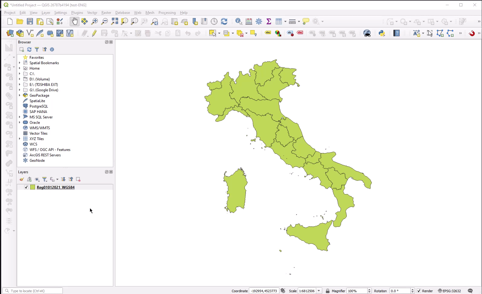
スプラッシュ画面には、ジュゼッペ・モリーニによる1847年のイタリアのフィレンツェの貴重な地図が表示されています。この素晴らしい地図は、1731年にフィレンツェの建築家フェルディナンド・ルッジェーリによって描かれたものです。地図は南を向いており、アルノ川の両岸に広がるフィレンツェの旧城壁中心部をカバーしています。右上の四分円にはフィレンツェのシンボルである百合の花が描かれている。この地図は1847年の印刷ですが、厚手の紙に銅版画で17世紀の様式で作成されています。1847年のフィレンツェは、政治的な変革の途上にありました。この貴重な地図が作られた翌年、トスカーナ大公はフィレンツェ中の政治的デモに応えて、トスカーナで最初の憲法を認めました。
新機能の紹介は、 YouTube のハイライト動画 https://youtu.be/IEkOhQezQMk でご覧いただけます。
また、開発者、ドキュメンター、テスター、そしてこれらのリリースを可能にするために時間と労力をボランティアで提供してくれた(またはそうするために人々に資金を提供してくれた)多くの人々に心から感謝します。 QGIS コミュニティから、このリリースを楽しんでいただければ幸いです。時間やお金を寄付したり、QGIS をもっと素晴らしいものにすることに参加したい場合は、 QGIS.ORG に行って手を貸してください!
QGIS は寄付者と維持会員によって支えられています。現在、プロジェクトに大小の金銭的な貢献をしてくださっている寄付者のリストは、寄付者リスト <https://qgis.org/en/site/about/sustaining_members.html#list-of-donors>`__ で見ることができます。プロジェクトの公式維持会員になりたい場合は、維持会員ページで詳細をご覧ください。 QGIS のスポンサーになることで、定期的な開発者ミーティングの開催、プロジェクトのインフラの維持、バグ修正のための資金を調達することができます。現在のスポンサー一覧は、以下のとおりです。
QGIS はフリーのソフトウェアです。利用する上で金銭を支払う義務はありません。実際、私たちは利用者の財政状況や社会的地位にかかわらず、より多くの人に QGIS を利用して欲しいと思っています。私たちは地理空間的な意思決定ツールによって人々が力を持つことが、全人類の社会をより良くすると信じています。
Breaking Changes
機能 シンボロジに関するQGIS 3.16以前とのプロジェクト下位互換性を省略
QGISの以前のリリースでは、QGIS 3.16およびそれ以前のバージョンでプロジェクトファイルを開くことができるようにするために、シンボロジの下位互換性を維持するために、プロジェクトファイルのXML構造に大量の互換性オブジェクトを書き込んでいました。この互換性は今後のリリースから削除され、プロジェクトファイル構造が大幅に最適化されます。
時系列
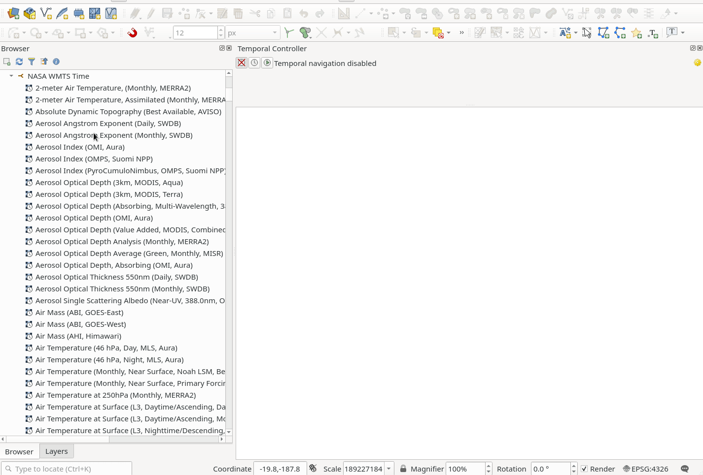
機能: TIMEディメンジョンを持つ WMTS レイヤの時系列マネージャサポートの追加
この機能強化により、WMTSの「時間」ディメンジョンが時系列フレームワークで使用できるようになり、これらのレイヤを時系列コントローラーでアニメーション化したり制御したりできるようになります。
WMTSレイヤで時間ディメンションを検出した場合、他の非時間ディメンションと同じ方法でこれを公開しなくなりました。ブラウザパネルにはディメンション値が表示されず、データソースマネージャ経由でレイヤを追加しても、利用可能な時間値から選択するようユーザーに促すことはなくなりました。代わりに、これらのレイヤは新しい "time capable raster layer"アイコンで表示され、ユーザーが時間値を指定しなくてもプロジェクトに追加されます。
WMS(T)レイヤと同様に、時間ディメンションが有効なWMTSレイヤがプロジェクトに追加されると、デフォルトで 「自動」時間モードになり、そのレイヤはデフォルトで時系列コントローラーの現在時間範囲に従います。ユーザーは、レイヤの時系列プロパティページから、「動的時系列コントロール」のチェックを外し、"Predefined date"オプションから特定の利用可能な時間範囲を選択することで、レイヤに特定の静的な時間値を表示することができます。
これにより、WMTS の時間対応レイヤの使い方は、WMS(T) レイヤの使い方と本質的に同じになるように、ユーザー体験が統一されるはずです。
この機能は Nyall Dawson によって開発されました。
ツール
機能: ベクタタイルレイヤで地物が選択できる
ベクタタイルレイヤから地物を選択する機能が追加され、標準のマップベースの選択ツールを使用して、これらのソースから地物を対話的に選択できるようになりました。
ベクタタイルレイヤに選択されたものがあるとき、ユーザーは次ができます:
その地物をコピーして、他のレイヤに貼り付けます、または、スクラッチレイヤに貼り付けます
「選択された地物にズーム」/「選択された地物にパン」など、選択されたものを操作する他の(編集しない)ツールを使います
矩形で選択、フリーハンドで選択、ポリゴンで選択、半径で選択など、対話的なマップ型の選択ツールのどれを使っても選択できます。ベクタ選択に適用される、選択範囲の追加/減算/交差のショートカットもすべて適用されます。
地物の選択はキャンバスのタイルズームレベルを使用して行われ、ユーザーがマップの縮尺を別のベクタタイルズームレベルに変更しても、このズームレベルで選択された地物は保持されます。つまり、ユーザーは拡大して小さい/詳細な地物を選択し、縮小してもマップ上で選択した地物を見ることができます。
この機能は Toitū Te Whenua Land Information New Zealand によって資金提供されました
この機能は Nyall Dawson によって開発されました。
ユーザーインタフェース
機能: データソースマネージャの専用ウィンドウ型UX
データソースマネージャダイアログは「常に」非モーダルとなり、そのように設定するためのオプションは取り除かれました。ダイアログは、スタイルマネージャやレイアウトマネージャなど、QGISの他の「マネージャ」タイプのウィンドウと同様に機能します。
データソースマネージャは独自のウィンドウとして扱われ、「データソースマネージャ」ボタンが押されるたびにフォアグラウンドに表示されます。
この機能は Nyall Dawson によって開発されました。
機能: 凡例クラスシンボルの右クリックメニューに、属性テーブルに表示アクションを追加
A new "Show in Attribute Table" action has been added to the right-click context menu of legend class symbols in the table of contents. This allows users to open the attribute table with a filter applied to match only the features relevant to a particular symbol group. This provides a significant performance improvement for certain datasets, such as large vector layers loaded from a remote source.
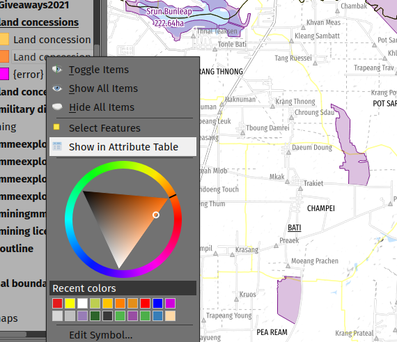
この機能は、Mathieu Pellerin によって開発されました
機能: 地物情報のNULL値を非表示にする設定の追加
The "Identify Features" utility now provides the capability to hide NULL values from the returned results
この機能は Camptocamp によって資金提供されました
この機能は、Ismail Sunni によって開発されました
シンボロジ
機能: GPS位置マーカーを制御できるようにする
A new general GPS options page has been introduced which includes new settings for controlling the marker symbol used for the current GPS location, and whether this symbol should be rotated to match the GPS direction.
この機能は Tiwi Resources, Bush Heritage, Australian Wildlife Conservancy によって資金提供されました
この機能は Nyall Dawson によって開発されました。
機能: 追加された新しい楕円マーカーの形状
楕円マーカータイプのシンボルスタイルに、以下の形状タイプが追加されました:
五角形
六角形
八角形
三分の一円
四分の一円
星
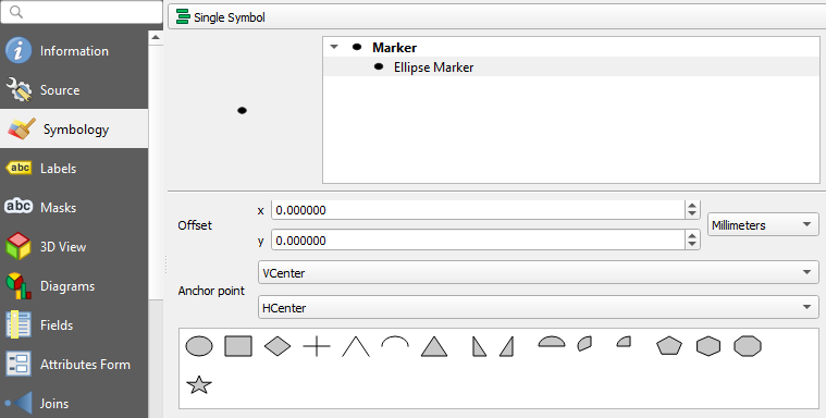
この機能は North Road によって資金提供されました
この機能は、ZayneTomlins によって開発されました
ラベリング
機能: ラベル付けのHTML 太字/斜体/フォントサイズ及びフォントファミリのサポートを追加
ラベリング内(およびテキストレンダラーが使用される他のあらゆる場所)で使用できるように、追加のHTMLフォーマット用タグのサポートが追加されました。
サポートされたタグには特に次が含まれます:
フォントファミリ
フォントサイズ
太字
斜体
この機能は スイスQGISユーザーグループによって資金提供されました
この機能は Nyall Dawson によって開発されました。
機能: 行の高さに絶対単位を使用するオプションを追加
Previously, the line height was always set in multiples of the text line spacing, however, it is now possible to use absolute units for line height (useful in contexts where mixed text sizes are used within a single document).
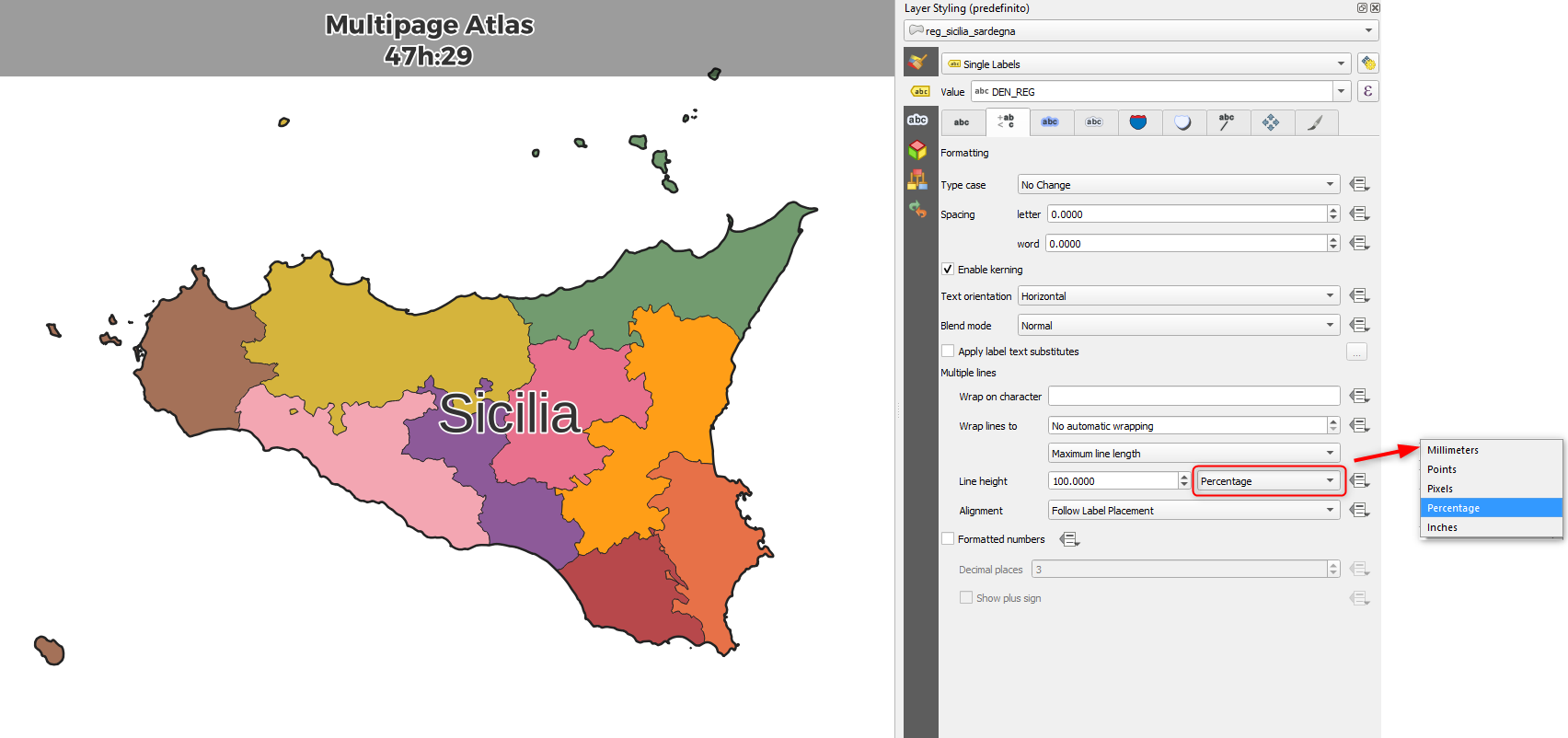
この機能は Nyall Dawson によって開発されました。
メッシュ
機能: メッシュレイヤの時間プロパティを再読み込みするオプションを追加
An "Always take reference time from data source" option has been added for mesh layers that when checked, will ensure that the reference time is reloaded from the data source, and each time the layer is reloaded or the project reopened the time properties will be updated from the file automatically.
In previous releases, when a mesh layer file had a reference time and time extent that changed, the time layer properties would not be updated when the projector layer are reloaded, and the user would be required to manually navigate to the "Reload from provider" feature in the temporal tab of the layer properties.
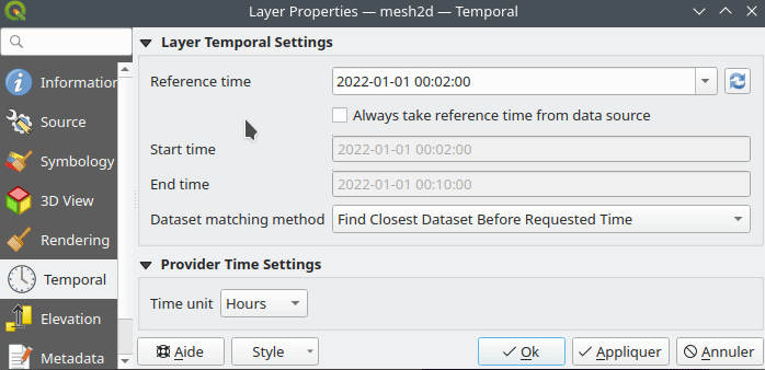
この機能は Vincent Cloarec によって開発されました
三次元機能
Feature: Ambient Occlusion 3D Effect
A new ambient occlusion effect is available for rendering data in 3D views that is useful for improving depth perception of the data in 3D. This is a post-processing effect and it can be even combined with eye dome lighting (EDL) for quite interesting results. An oversimplification of the effect is that features that are not visible to the camera are used to texture and darken neighboring elements, with the benefit of improving contrast, feature definition, and differentiation.
There is a new item for controlling the state of Ambient Occlusion in the configuration menu for 3D views, as well as extra parameters in the advanced section of the configuration dialog for fine-grained control over:
Radius: The distance threshold for calculating ambient occlusion
Intensity: The strength of the effect should be (higher values make things darker)
Occlusion threshold: Number of neighboring points that need to be occluded for the effect to appear (values lower than 50% will make the output darker, but possibly provide a greater range of occlusion)
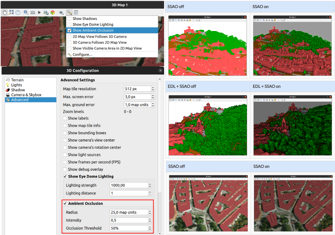
この機能は Martin Dobias & Belgacem Nedjima によって開発されました
点群
機能: 点群レイヤのエクスポート
Point Cloud layers now support being exported to vector or point cloud data formats, with optional filtering.
サポートする形式には次があります:
一時スクラッチレイヤ(メモリレイヤ)
GeoPackage
シェープファイル
DXF
LAZ(WITH_PDALを使ったビルドが必要)
非圧縮のLASファイル
エクスポート操作は次によるフィルタリングをサポートします:
領域
Zレンジによるフィルタリング
エクスポートするポイントの数の限定
ポリゴンレイヤによる空間フィルタリング
更に、CRS定義の出力と再投影もサポートされます
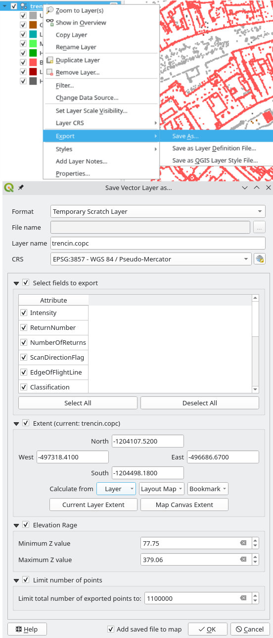
この機能は State of Vorarlberg and Swiss QGIS user group によって資金提供されました
この機能は Stefanos Natsis によって開発されました
地物: 2Dマップキャンバス内の点群のアイドーム照明
点群の2Dレンダラで、アイドーム照明効果が利用可能になりました
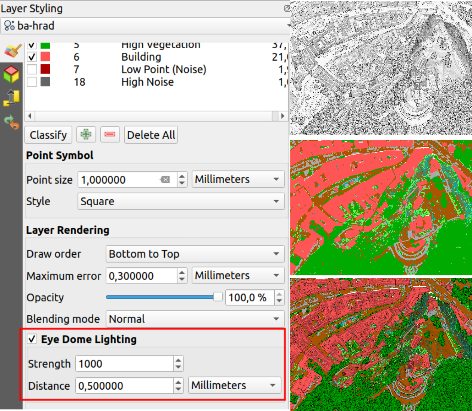
この機能は Nedjima Belgacem によって開発されました
印刷レイアウト
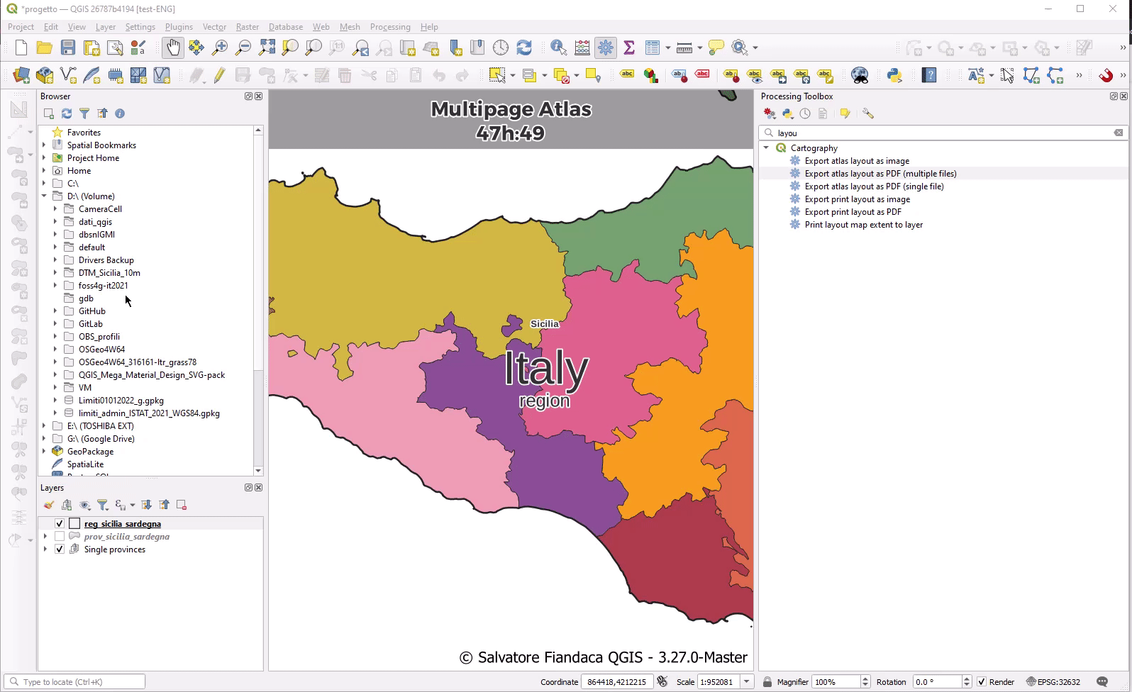
機能: PDFアルゴリズムに FORCE_RASTER と IMAGE_COMPRESSION パラメータを追加
The FORCE_RASTER and IMAGE_COMPRESSION parameters have been added to the various "Export print layout as PDF" algorithms, including support for Atlas and multifile exports.
FORCE_RASTER is mutually exclusive with and takes precedence over the FORCE_VECTOR parameter.
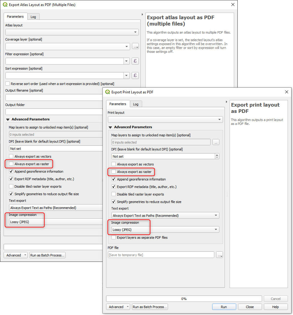
この機能は Andrea Giudiceandrea によって開発されました
計算式
機能: 現在の地物表現関数に新しい変数の形式を追加
式の中で現在の地物とその属性を参照する、新しいスタイルの変数の形式が追加されました。
新しく導入された変数は:
@feature: 現在の地物を格納する、$currentfeature の後継@id: 現在の地物idを格納する、$id の後継@geometry: 現在の地物のジオメトリを格納する、$geometryの後継
これは最終的に古い $ スタイルの関数を非推奨にするためのステップであり、予測不可能な @/$ の混在ではなく、より一貫した式のアプローチを提供するものです。
古い関数や変数参照は引き続き動作します(古いプロジェクトとの互換性のため、おそらく無期限に動作し続けるでしょう)。また、ユーザーの混乱を避けるため、それらは(当分の間)UIで公開され続けます。
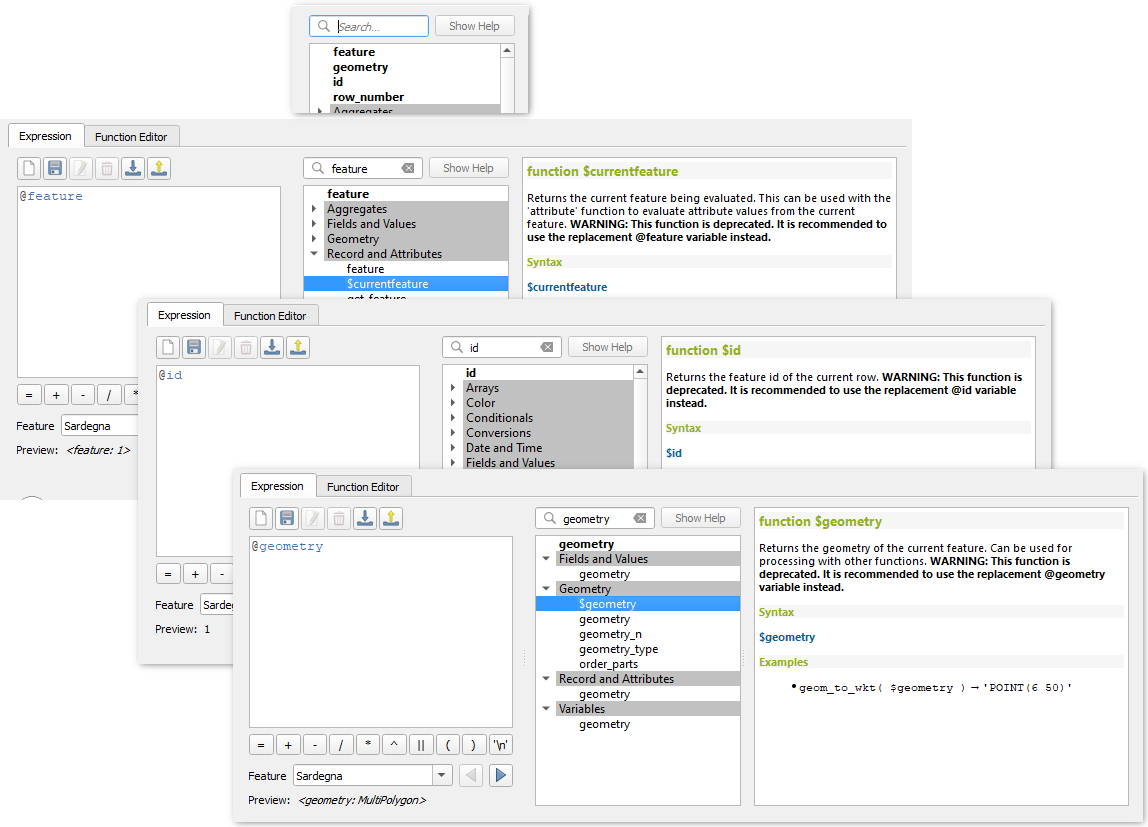
この機能は Nyall Dawson によって開発されました。
機能: 新規 shared_paths 関数を追加
A new shared_paths function has been added which returns a collection containing paths shared by the two input geometries. Those going in the same direction are in the first element of the collection, and those going in the opposite direction are in the second element. The paths themselves are given in the direction of the first geometry.
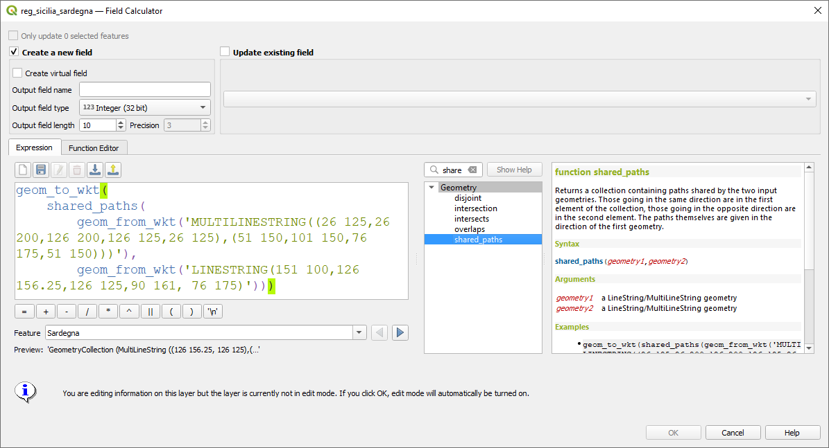
この機能は Nyall Dawson によって開発されました。
機能: make_valid 及び geom_to_array 関数
Additional functions have been added for:
make_valid: Repair broken input geometries and returns the corrected geometriesgeometries_to_array: This converts a geometry collection into an array for easier handling and iteration
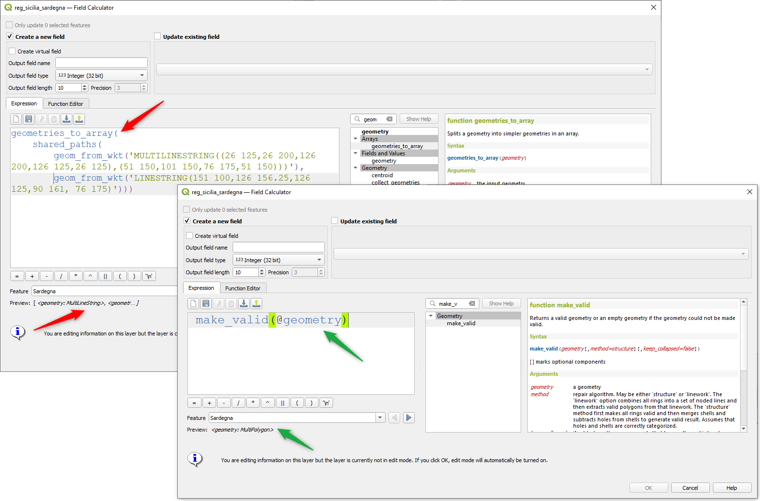
この機能は Alex によって開発されました
機能: concave hull 関数
A new concave_hull function is now available in QGIS expressions (GEOS 3.11+)
この機能は Loïc Bartoletti によって開発されました
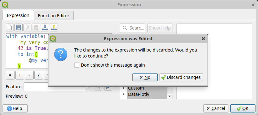
機能: 式の変更を破棄する際に確認を求める
A new confirmation dialog is now safeguarding users against accidentally discarding their unapplied changes in expression editor dialogs. This safeguard is used in the Expression String Builder, the Expression Dialog (Epsilon icon, e. g. for Geometry Generators or for Pre-calculated Values in the model builder) and the Expression Based Filter (Attribute Table -> Advanced filter expression).
この機能は WhereGroup GmbH によって資金提供されました
この機能は Johannes Kröger によって開発されました
データ管理
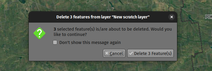
機能: 地物を削除するときに確認を求める
A new confirmation dialog appears by default when users perform an action that would delete records, such as using the DEL key or toolbar actions, to further reduce the risks of accidental feature deletion. Additionally, the feature count is now included in the dialog message itself (and is also still displayed in the title bar), making the total number of features deleted more clear to users.
In previous releases, similar confirmation prompts would only be displayed when some features fell out of the extent of the map canvas, or the deletion triggered the removal of child relation features. The new behavior is for the prompt to be enabled by default and disabled by using the "Don't show this message again" checkbox.
この機能は QGIS user group Switzerland によって資金提供されました
この機能は、Mathieu Pellerin によって開発されました
メタデータとメタサーチ
機能: レイヤメタデータのデータプロバイダの検索と保存
Implementation of elements from the QEP #250 "Database metadata storage" initiative have been completed and this functionality includes the creation of a new layer metadata API and GUI components.
次のデータプロバイダ/形式は、QGISでレイヤのメタデータを保存および管理するためにサポートされています:
GPKG (it was implemented already, I just wrapped it into the new API)
Postgres
Postgresラスタ
In addition, a new layer metadata search tab is available from the data source manager, and an interactive layer metadata search is available using the QGIS locator.

この機能は ARPA Piemonte によって資金提供されました
この機能は Alessandro Pasotti によって開発されました
プロセシング
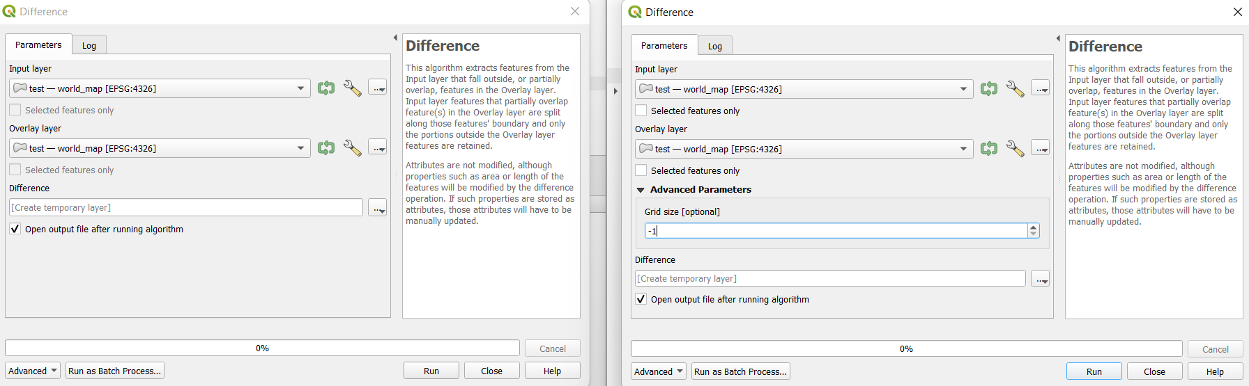
機能: 選択したプロセシングツールに対する固定精度サポートが修正されました
新しい高度なパラメータがいくつかのプロセシングツールで利用可能になりました。これにより、GEOS >= 3.9.0 で提供される 固定精度 パラメータを使用することができます。このパラメータは「グリッドサイズ」として高度なパラメータの下にリストされており、現在以下のツールでサポートされています:
重なる (Overlap)
交差(intersect)
差分(Difference)
対称差分(symmetrical difference)
和集合(union)
この機能は Orange Telecom FR によって資金提供されました
この機能は Loïc Bartoletti によって開発されました
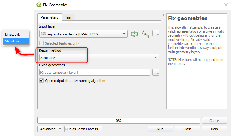
機能: 「有効にする」アルゴリズムの改善
QGIS can now use the newer refined GEOS 3.10+ methods for validating and repairing geometry features.
この機能は Nyall Dawson によって開発されました。
機能:プロセシングからのベクタ出力の地物の数を表示するデフォルトオプション
A new Show feature count for output vector layers setting is available (but disabled by default for performance reasons), which will automatically enable the "show feature count" option on output layers loaded from QGIS processing. This is able to give users a first glimpse of what to expect as an output from a Processing algorithm.
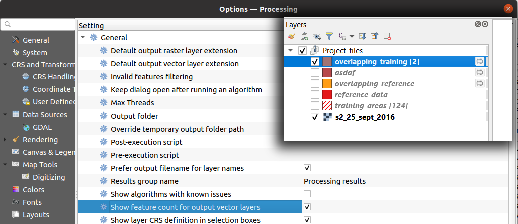
この機能は Germap によって開発されました
機能: レイヤをGeoPackage化アルゴリズムにリレーションをエクスポートするオプションを追加
The "Package Layers" processing tool now supports optionally following project relations and exporting related tables following the hierarchy both upstream and downstream, whilst also taking selected features into account.
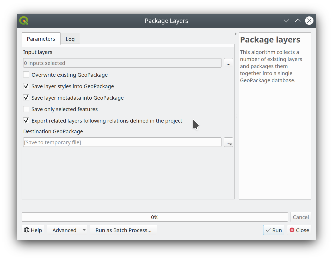
この機能は ARPA Piemonte によって資金提供されました
この機能は Alessandro Pasotti によって開発されました
機能: 「ドレープ」アルゴリズムに「オフセット」パラメータを追加
Adds the "Offset" parameter to the "Drape (set Z value from raster)" and "Set M value from raster" algorithms. The "Offset" value is algebraically added to the band values after applying the "Scale factor".
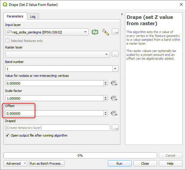
この機能は Andrea Giudiceandrea によって開発されました
アプリケーションとプロジェクトのオプション
機能: プロジェクトの座標と方位の表示設定を変更
The Coordinate and Bearing Display options in the project settings have been updated in line with the following:
Map Units (behavior is the same as previous releases)
Map Geographic (modified behavior)
Custom Projection Units (new type)
The legacy Geographic (Latitude/ Longitude) option would display values in the map CRS coordinates if the CRS was geographic, otherwise, it would transform coordinates to a hard-coded WGS84 CRS value.
The updated Map Geographic (degrees) option, which supersedes the legacy approach, will display values in the map CRS coordinates if the CRS is geographic, however in instances where it is not, the internal QgsCoordinateReferenceSystem::toGeographicCrs() API will be used to transform the coordinates into the map CRS' associated geographic CRS. This is helpful in various contexts, such as when analyzing non-earth celestial bodies.
The Custom Projection Units type is a new addition that defaults to WGS84 and allows users to set any CRS they desire as display coordinates.
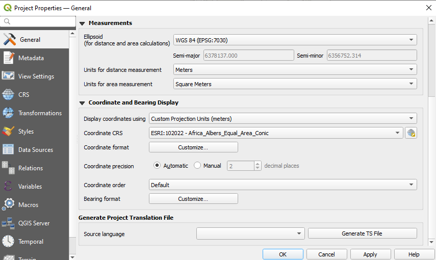
この機能は、Mathieu Pellerin によって開発されました
機能: 「ユーザー」フォントのサポート及びフリーライセンスのフォントの自動ダウンロードを追加
A new "Fonts" panel has been added to the settings dialog, which provides support for the following functionalities:
The ability for users to populate a list of automatic font replacements to apply when loading projects or styles, allowing better support for projects and styles to be used across different operating systems (e.g. replace "Arial" with "Helvetica").
Users can now place TTF or OTF fonts in the "fonts" subfolder of their user profile. These fonts will automatically be loaded at QGIS startup time. This provides a way for users to use fonts without requiring them to be installed on an operating system level, which is often blocked in enterprise environments. The Fonts setting panel lists all installed user fonts and allows users to manage (i.e. remove) previously installed user fonts
An API is provided for other tools, such as plugins and other clients, to specify additional user font folders which should be scanned during QGIS startup
Automatic downloading of missing fonts is now supported in certain circumstances. If a user opens a project or style, or they try to load a vector tile layer that references fonts that aren't currently available, then a hard-coded list of freely licensed fonts to download via URL is consulted to determine whether it's possible to automatically download the font to the user font directory (and notify the user of the font license). A setting to opt out of this behavior is provided in the Fonts panel if so desired.
この機能は Toitū Te Whenua Land Information New Zealand によって資金提供されました
この機能は Nyall Dawson によって開発されました。
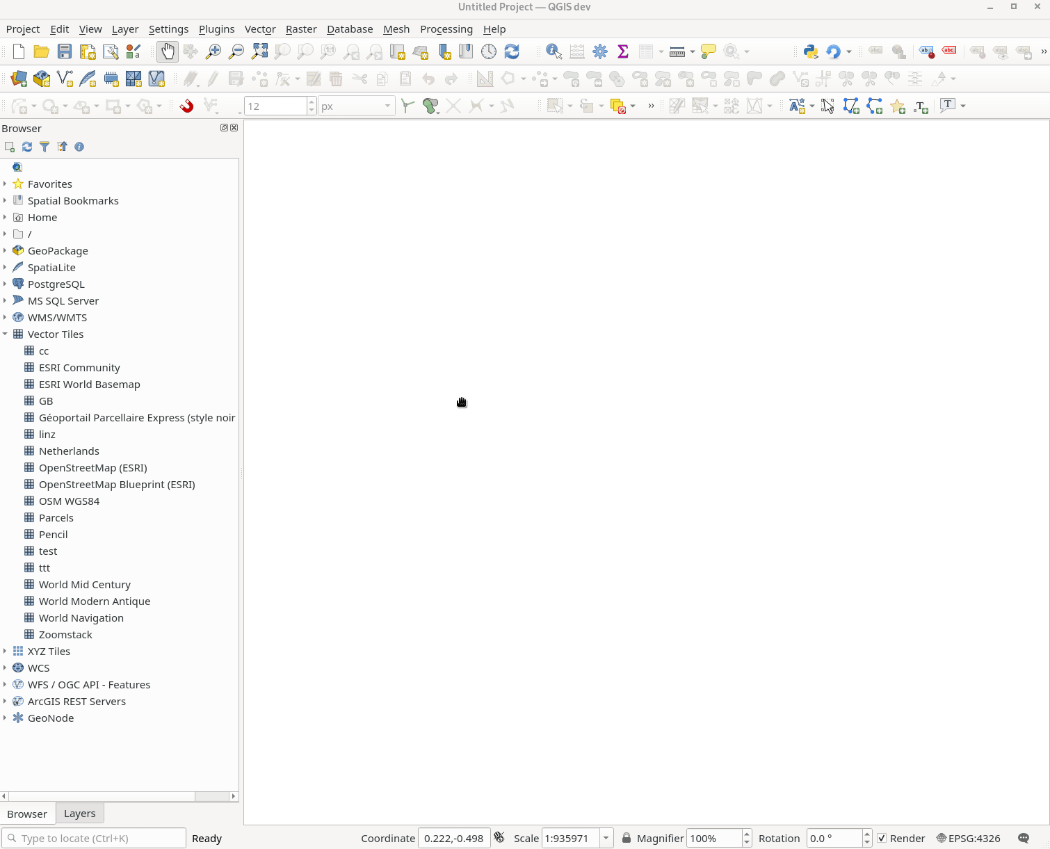
ブラウザ
機能: OGRレイヤのリレーションシップ検索を実装し、ブラウザでリレーションシップを表示する
The Project Properties → Relations → Discover Relations feature is now able to support OGR layers that support relationships, such GeoPackage (via the related tables extension) and ESRI FileGeodatabases.
The QGIS Browser Panel now includes the ability to show detailed relationship information for these data sources.
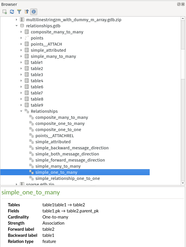
この機能は Nyall Dawson によって開発されました。
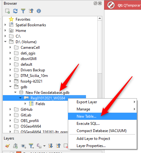
機能: GeopackageとESRIファイルGeodatabase生成のUXを変更
A "New ESRI File Geodatabase" action has been added to the QGIS Browser right-click context menu on directories, and a new "vacuum" action is available for GDB files. (requires GDAL 3.6+)
Additionally, creating a new Geopackage from the same menu will now immediately create an empty GPKG, rather than the legacy behavior of opening a table creation dialog by default (and requiring table creation or users to input dummy data).
https://user-images.githubusercontent.com/1829991/178902332-0e112e73-0140-45b9-84bf-fc7875cb7b98.gif
この機能は Nyall Dawson によって開発されました。
機能: GPKGでないOGRデータベースデータセットにベクタレイヤをドラッグ&ドロップできるようにした
QGIS now allows drag and drop of vector layers between OGR database datasets that are not stored in GPKG format, for instance, the dragging of a layer onto a GDB to import that dataset into the geodatabase
この機能は Nyall Dawson によって開発されました。
機能: 非gpkg OGR ソースのフィールドドメイン管理を見えるようにする
The QGIS browser now supports more advanced functionalities for OGR databases that are not in GPKG format, including Field domain management capabilities (creation and listing domains) and table creation. This means that users can manage field domains and create new tables in an existing ESRI FileGeodatabase database from the QGIS Browser interface.
この機能は Provincie Gelderland によって資金提供されました
この機能は Nyall Dawson によって開発されました。
データプロバイダ
機能: PostgreSQL接続のセッションロールを定義する
A session_role setting can now be specified for PostgreSQL connections to set the user identifier of the active SQL session. Permissions checking for SQL commands are then carried out with the associated named role.
This is highly useful in instances where it is desirable to automatically give ownership of new objects (Tables/ Views/ Functions etc.) to the session_role group, and share ownership and the associated rights with all members of the session_role group.
The specified session_role must be a role that the current session user is a member of, or if the session user is a superuser, any role can be selected.
この機能は 3liz によって資金提供されました
この機能は rldhont によって開発されました
機能: arcgis REST レイヤにサブセット文字列(フィルタ)サポートを追加
This can greatly improve the performance on large layers!
この機能は Naturstyrelsen and Miljøstyrelsen, Danish Ministry of Environment によって資金提供されました
この機能は Nyall Dawson によって開発されました。
機能: フィールド名を変更するための抽象データベースプロバイダ
A QgsAbstractDatabaseProviderConnection interface has been added for supporting renaming fields, and implemented for OGR connections along with the ability to rename existing fields for supported database connections via the QGIS Browser interface.
この機能は Nyall Dawson によって開発されました。
Feature: WFS performing binary spatial operations in expressions on server
QGIS used to be able to perform the expression filters of binary spatial operations on the server when the geometry was provided as WKT or in the GML format. This change converts the geometry from being a static variable in the expression to an OGC filter. The WFS URL is then created by combining a bounding box rectangle, layer filter, and the filtering expression.
A feature request computes the expression in advance to find out if it can be performed on the server, then it's stored in QgsBackgroundCachedSharedData where a new download is triggered.
When a filter request is not a pure binary spatial operation, it will not be evaluated on the server.
この機能は Kanton Schaffhausen によって資金提供されました
この機能は signedav によって開発されました
Feature: Editing ArcGIS REST Layers
QGIS now supports the editing of ArcGIS feature server layers, such as those hosted on ArcGIS online. Assuming the user has appropriate permissions granted for editing a layer, it will unlock the ability to use the native QGIS tools to edit that layer. These changes include support for the following operations:
Deleting features
Adding new features
Curved geometries (only supported for enterprise ArcGIS server, as ArcGIS online currently has no support for curves)
Modifying existing features
Modifying attributes (creating fields, deleting fields, creating attribute indexes)
この機能は Naturstyrelsen and Miljøstyrelsen, Danish Ministry of Environment によって資金提供されました
この機能は Nyall Dawson によって開発されました。
Feature: Load raster sublayers from vector tile styles automatically
When loading a new vector tile source into a project, if the associated MapBox GL style includes any raster sublayers, then also load those into the project with converted styles.
Fixes https://github.com/qgis/QGIS/issues/46593

この機能は Toitū Te Whenua Land Information New Zealand によって資金提供されました
この機能は Nyall Dawson によって開発されました。
Feature: Add WMS layers individually
In previous releases, the selection of layers from WMS Servers would be loaded into QGIS as a single project layer. This new functionality provides an optional checkbox to load each of the selected WMS layers into QGIS as distinct project layers.
この機能は Camptocamp によって資金提供されました
この機能は、Ismail Sunni によって開発されました
Feature: Save projects to Oracle Database Provider
QGIS now supports saving projects to Oracle databases.
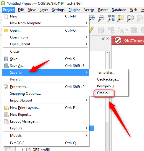
この機能は Julien Cabieces によって開発されました
QGISサーバー
機能: QGIS_SERVER_ALLOWED_EXTRA_SQL_TOKENS 設定の変数
This new feature allows specifying extra tokens which may be used for a WMS FILTER definition. The current list of accepted tokens is rather small and this setting will allow system administrators to easily enlarge the list of allowed tokens.
この機能は Zweckverband Grevesmühlen によって資金提供されました
この機能は Alessandro Pasotti によって開発されました
Feature: Open layers in a read only mode with QGIS Server
A new QGIS_SERVER_FORCE_READONLY_LAYERS environment variable to force QGIS Server to open layers in read-only mode.
This includes various underlying API changes to support read-only configuration for data provider construction, project structure, and layer properties.
この機能は Ifremer によって資金提供されました
この機能は rldhont によって開発されました
プラグイン
機能: プラグインの自動アップデート動作の変更
This change moves the old app/plugin_installer/checkOnStart setting key to a new plugins/automatically-check-for-updates key, and switches the default value to enable automatic checks.
This is designed to switch all existing QGIS users to the new default behavior of checking for plugin updates at startup (at a maximum of once every 3 days).
It is intended to offer a better QGIS experience to our users, by proactively informing all users when plugins should be updated, ensuring that ALL users are more likely to upgrade plugins and get the bug fixes for plugins promptly.
Enterprise users who have customised this setting in their deployments will need to adapt their scripts for the new setting key.
Additionally, the option to control the number of days between plugin startup checks has been removed and is hardcoded at 3 days.
この機能は Nyall Dawson によって開発されました。
プログラム可能
Feature: Add temporal handling to maps in QGIS Quick
A new implementation has been added to allow the Canvas and Map Settings in QGIS Quick to handle temporal functionality.
この機能は、Mathieu Pellerin によって開発されました
機能: py-argsコマンドラインパラメータの追加
When running QGIS from the command line with the --code parameter, a new --py-args utility allows the passing of arguments to the python interpreter.
Arguments between --py-args and -- are passed to the python interpreter and ignored by QGIS, so for example, when using the following command:
qgis --code /home/user/example.py --py-args --specialScriptArguments "arg1" 'arg2' -- layer1 layer2
The example.py script will have --specialScriptArguments, arg1, and arg2 passed as system arguments to the python interpreter, whilst layer1 and layer2 will be handled by QGIS normally and loaded as map layers
この機能は Landesamt für Vermessung und Geoinformation Vorarlberg によって資金提供されました
この機能は Damiano Lombardi によって開発されました
注目すべき修正
機能: Alessandro Pasotti によるバグ修正
バグの表題 |
URL issues.qgis.org (報告された場合) |
URL Commit (Github) |
3.22 backport commit (GitHub) |
|---|---|---|---|
GetPrint request of Atlas Template doesn't respect Project scales |
|||
Attribute Table Integer entries not showing due to window size |
Not recommended |
||
WFS3 collections field name/displayName mix in request/response |
Not recommended |
||
QGIS Server WMS GetFeatureInfo does not evaluate represent_value expression in maptip |
|||
"evaluate default value on providers side" block insert on table in the schema with autoincrement |
|||
QGIS not responding when entering page size using custom width or height fields |
再現できません |
||
"Add Directory..." inputs files from previous selected directory at first instance, then the corret. |
|||
Layer style panel and Layer panel do not show same visibility settings for layer style |
再現できません |
||
Crash while opening Options dialog after switching locale |
必要なし |
||
未報告のMSSQL接続APIのエラー |
未報告 |
||
Identify and select tools don't work with geometry-based query layers |
再現できません |
||
Problem with Reloading SLD file in QGIS |
queued |
||
Unreported endless alg splitwithlines |
未報告 |
Not recommended |
|
Processing algorithm "Split with lines" does not split polygon |
バグではない |
||
式が複数行の文字列を分割しない |
|||
Problem with exportation of complex SLD |
|||
Wrong interpretation of SLD color opacity |
バグではない |
||
SLDエクスポート/インポートのラベルサイズ誤り |
必要なし |
||
Exporting SLD doesnt include fill-opacity |
|||
SpatiaLite - Added feature vanishes, attribute dialog does not show required fields |
queued |
この機能は QGIS.ORG (through donations and sustaining memberships) によって資金提供されました
この機能は Alessandro Pasotti によって開発されました
機能: Even Rouault によるバグ修正
バグの表題 |
URL issues.qgis.org (報告された場合) |
URL Commit (Github) |
3.22 backport commit (GitHub) |
|---|---|---|---|
GML import is missing one feature without geometry |
Not appropriate |
||
WFS/QgsOapifProvider does not take the pageSize from the dialog into account |
必要なし |
||
[WFS] Layer is added incorrectly as mixed geometry collection |
|||
WFS: missing namespace prefix on geometry and attribute elements in FILTER for WFS GetFeature reques |
|||
[Processing] Fix typo in smoothing parameter name of gdal_grid algorithms |
未報告 |
||
WFS client shows wrong CRS |
|||
QGIS doesn't work properly with WFS 2.0.0 combined with OGC HTTP URI srsName style (e.g. http://www.opengis.net/def/crs/EPSG/0/xxxx) |
|||
QGIS ignores field inherited from parent feature type in WFS 2.0 services |
Not appropriate |
||
Loading and displaying CADRG/NITF data is slower than it used to be |
|||
world_map.gpkg: little fix to avoid warning with recent GDAL versions |
未報告 |
必要なし |
|
QGIS 3.24.1 (Windows) destroys my VRT raster mosaic |
PR #50328Bug Title |
||
-- |
-- |
-- |
-- |
GML import is missing one feature without geometry |
Not appropriate |
||
WFS/QgsOapifProvider does not take the pageSize from the dialog into account |
必要なし |
||
[WFS] Layer is added incorrectly as mixed geometry collection |
|||
WFS: missing namespace prefix on geometry and attribute elements in FILTER for WFS GetFeature reques |
|||
[Processing] Fix typo in smoothing parameter name of gdal_grid algorithms |
未報告 |
||
WFS client shows wrong CRS |
|||
QGIS doesn't work properly with WFS 2.0.0 combined with OGC HTTP URI srsName style (e.g. http://www.opengis.net/def/crs/EPSG/0/xxxx) |
|||
QGIS ignores field inherited from parent feature type in WFS 2.0 services |
Not appropriate |
||
Loading and displaying CADRG/NITF data is slower than it used to be |
|||
world_map.gpkg: little fix to avoid warning with recent GDAL versions |
未報告 |
必要なし |
|
QGIS 3.24.1 (Windows) destroys my VRT raster mosaic |
この機能は QGIS.ORG (through donations and sustaining memberships) によって資金提供されました
この機能は Even Rouault によって開発されました
機能: Julien Cabiecesによるバグ修正
バグの表題 |
URL issues.qgis.org (報告された場合) |
URL Commit (Github) |
3.22 backport commit (GitHub) |
|---|---|---|---|
QGIS not retrieving sequence from postgis in 3.26 |
no need to bp |
||
SVG is not rendered for SVG Marker symbol |
Cannot fix, Qt issue |
||
If "estimated metadata" option is checked, feature count for tables/postgis do not work |
|||
Variable raster image source in composer not working |
|||
Print Layout Picture Box reverting to SVG |
|||
Layout picture can not change SVG image to Raster image |
|||
QgsOptionsPageWidget - helpKey and helpSearchPath are not working |
|||
Freeze when opening WFS attribute table from HTTPS server with SSL exception |
no bp |
||
News feed not loading when using MSI installer |
no bp |
||
.ci/run_tests.sh: test_core_networkaccessmanager (Timeout) |
|||
SVG Symbol on newer version of QGIS (3.22.7/8/10 tested) make the software lag a lot (and not on 3.4 version). |
Feedback, not sure it’s a bug |
||
Empty Options drop-down menu in Query Logger tab |
no bp |
||
Build fails with WITH_POSTGRESQL=OFF |
フィードバック |
||
Build fails with WITH_GSL=OFF |
|||
QGIS master exports out of bounds in layout |
Cannot fix, Qt issue |
||
Layout bleeding to edge outside map window |
Cannot fix, Qt issue |
||
Freeze with virtual field on $area used as parameter in sum |
この機能は QGIS.ORG (through donations and sustaining memberships) によって資金提供されました
この機能は Julien Cabieces によって開発されました
機能: Paul Blottiereによるバグ修正
バグの表題 |
URL issues.qgis.org (報告された場合) |
URL Commit (Github) |
3.22 backport commit (GitHub) |
|---|---|---|---|
QGIS Server WFS 1.1.0 GetFeature response - properties with xsi:nil="true" |
|||
Cannot move labels |
再現できません |
||
Auxiliary storage and removed layers |
Not recommended |
||
OPACITIES parameter not handled with Vector Tile layer in GetMap/GetPrint |
|||
Fixes log messages when a job error is not related to a specific layer |
未報告 |
必要なし |
|
Labels: Data defined override of "Show Label" always wants the auxiliary storage option |
|||
Auxiliary storage rotation or offset fields for symbols are visible by default while labels are not |
|||
Improve selection of PostGIS raster overviews |
未報告 |
この機能は QGIS.ORG (through donations and sustaining memberships) によって資金提供されました
この機能は Paul Blottiere によって開発されました
Feature: Sandro Santilliによるバグ修正
バグの表題 |
URL issues.qgis.org (報告された場合) |
URL Commit (Github) |
3.22 backport commit (GitHub) |
|---|---|---|---|
Crash with offline-editing-core-plugin converting to offline project layer with empty polygon |
|||
Cleanup temporary python test config path when requested |
|||
Include type name in message about unsupported qfield validations |
未報告 |
この機能は QGIS.ORG (through donations and sustaining memberships) によって資金提供されました
この機能は Sandro Santilli (strk) によって開発されました
機能: Nyall Dawsonによるバグ修正
バグの表題 |
URL issues.qgis.org (報告された場合) |
URL Commit (Github) |
3.22 backport commit (GitHub) |
|---|---|---|---|
Fix regression in column break calculations in legends |
Not suitable -- too risky |
||
Fix tracing fails when layer crs differs from map crs |
Not required |
||
Show only available CRS in WMS layer selection widget |
Not required |
||
Fix some overlay algorithms output multipoint geometries but output layer is single point, causing insertion errors |
|||
Fix missing information in crash reports on Windows |
Not required |
||
Fix regression where attribute table dialogs do not open as proper top level windows with their own taskbar entries |
Not required |
||
[georeferencer] Fix options ignored when "create world file only" is active |
Not required |
||
Ensure identify tool uses correct labels for x/y values when coordinate axis order for project is y/x |
Not required |
||
Ensure coordinate display in status bar updates immediately when related settings change, and update the tooltip to match the actual values displayed in the widget |
Not required |
||
Fix rendering of linestrings with nan z values |
Not required |
||
Fix broken logic in clearing python console history |
未報告 |
||
Fix QgsFileWidget does not reactivate widget's window after selecting a file/folder via the browse button on mac |
未報告 |
||
Fix code folding not shown for non-python code editor classes |
未報告 |
||
Fix leak in GEOS geometry library use |
未報告 |
||
Fix raster contour renderer ignores opacity setting |
Not suitable -- too risky |
||
Fix truncation of recent project list removes too many items, raises a warning |
未報告 |
||
Fix dizzy easter egg |
Not required |
||
Fix point pattern fill sometimes ignores symbol opacity setting |
Not suitable -- too risky |
||
Fix broken path in svg raises Qt warnings while rendering |
未報告 |
||
Ensure correct expression context is used when generating symbol preview icons |
Not suitable -- too risky |
||
[spatialite] Fix corrupted default attribute values when fields are loaded using gaiaVectorLayer |
個人的な報告 |
||
Fix handling of vector tiles when zoom level 0 is not available |
Not required |
||
ジオリファレンサウィンドウへのファイルのドラッグ&ドロップを修正 |
Not required |
||
Never try to handle base parameter type values as map layers in QgsProcessingParameterDefinition::valueAs* methods |
Not required |
||
Avoid a redundant calculation of visible layer extent in overview canvas |
未報告 |
||
Show standard Rendering tab in point cloud layer properties, add missing scale range widget to mesh layer properties |
Not suitable |
||
Show standard Rendering tab in point cloud layer properties, add missing scale range widget to mesh layer properties |
Not suitable |
この機能は QGIS.ORG (through donations and sustaining memberships) によって資金提供されました
この機能は Nyall Dawson によって開発されました
機能: Loïc Bartoletti によるバグ修正
バグの表題 |
URL issues.qgis.org (報告された場合) |
URL Commit (Github) |
3.22 backport commit (GitHub) |
|---|---|---|---|
Fix "Add Ring" tool doesn't consider all the overlapping features |
Not suitable - add new methods |
||
Fix wkbType cast from OGR 25D Type |
この機能は QGIS.ORG (through donations and sustaining memberships) によって資金提供されました
この機能は Loïc Bartoletti によって開発されました