QGIS 3.20の変更履歴

リリース日: 2021-06-18
QGIS 3.20 Odenseは、1593年からデンマークで3番目に大きい都市の `オーデンセ<https://en.wikipedia.org/wiki/Odense>`__ の 最古の地図 セクションを表示するスプラッシュ画面を備えています。この地図は ゲオルク・ブラウン (1541-1622) によって作品 Civitates orbis terrarum (世界の諸都市)の中で出版されました。ゲオルク・ブラウンの地図はすべて美しく、当時は高い地図作成レベルで作成されていました。 Civitates orbis terrarum は長い間、 パリ 、 ロンドン 、 メキシコシティ 、 Aden などの世界の都市の地図の主な情報源でした。
オーデンセという名前は文字通り「オーディンの寺院」を意味し、その場所はもともと異教の神オーディンの神社であった可能性があります。地図の左下には、デンマークのバイキング王である ハーラル1世 (985/86年頃に死亡)によってデンマークに建設されたバイキング時代の大きな環状要塞の1つの遺跡が見えます。オーデンセの環状要塞は Nonnebakken と呼ばれています。
このリリースでは、最近のQGISのリリースで導入された最新の豊富な機能の一覧を強化する、たくさんの微妙な変更と安定性の更新が導入されています。このリリースには、データ管理の改善が数多く含まれており、CRSシステムと投影法の情報の管理と表示にいくつかの高度な変更が加えられています。これらのCRS管理の改善の中には、動的CRSシステムの座標エポックの基本的なサポートや高度な性格度の整合性の警告などが含まれており、高精度システムのGISとデータ管理の実践の最先端に位置するQGIS 3.20を確立しています。
さらに、ユーザーはメタデータの管理と、特定のデータやメタデータタイプの処理の改善を期待できます。もう一つの重要なハイライトは、nominatim ジオコーディング・サービスのネイティブ統合で、これによりユーザーはOpenStreetMapプロジェクトのデータを使って、QGISのロケーターバーから直接場所や住所を検索できるようになります。
QGISコミュニティは、QGIS HUB における活動の増加も見られ、さらには仮想QGISオープンデイでも活発な動きがありました。Cutting Edge Open Day では、最新のリリースで導入された豊富なQGISの機能を活用したデモンストレーションが数多く披露されました。
また、開発者、ドキュメンター、テスター、そしてこれらのリリースを可能にするために時間と労力をボランティアで提供してくれた(またはそうするために人々に資金を提供してくれた)多くの人々に心から感謝します。 QGISコミュニティから、このリリースを楽しんでいただければ幸いです。時間やお金を寄付したり、QGISをもっと素晴らしいものにすることに参加したい場合は、 QGIS.ORG に行って手を貸してください!
QGISは寄付者と維持会員によってサポートされています。プロジェクトへの大小の献金を行った寄付者の現在のリストは、 寄付者リスト に掲載されています。公式のプロジェクト維持会員になりたい場合は、 維持会員ページ に行って詳細をご覧ください。QGISに出資いただけると、定期的な開発者会議への資金提供、プロジェクトインフラストラクチャの維持、バグ修正作業への資金提供に役立ちます。現在のスポンサーの完全なリストを以下に示します。すべてのスポンサーに大変感謝します。
QGIS はフリーのソフトウェアです。利用する上で金銭を支払う義務はありません。実際、私たちは利用者の財政状況や社会的地位にかかわらず、より多くの人に QGIS を利用して欲しいと思っています。私たちは地理空間的な意思決定ツールによって人々が力を持つことが、全人類の社会をより良くすると信じています。
一般情報
機能: 属性テーブルを開く追加オプション
以前に利用可能だった属性テーブルを開くためのショートカットや、フィルタを使用して選択されたアイテムやキャンバス内の表示されているアイテムのみを表示するためのショートカットは、メニューツールバーに統合され、特に大規模なデータセットで作業する際に利便性とユーザーエクスペリエンスを向上させるために使用されるようになりました。
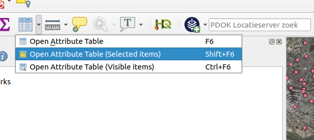
この機能は Raymond Nijssen によって開発されました
機能: 属性テーブルの全てのカラムの大きさを設定
既存の「幅を設定」と「自動サイズ」機能は、フィールドのサイズ変更を全ての列に適用するために拡張されました。
この機能には、固定幅の設定やすべての列を「自動サイズ」にする機能が含まれています。これらの操作は、フィールドヘッダーを右クリックすることでアクセスできる、属性テーブルヘッダーコンテキストメニューから利用できます。
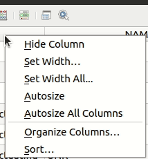
この機能は Ben Wirf によって開発されました
機能: 認証設定のエクスポート/インポートが簡単になりました
QGIS 3.20から、ユーザーはQGIS設定の認証パネル内の一連のアクションを使用して、認証設定を簡単にエクスポートおよびインポートすることができます。エクスポートされた設定は、機密情報の漏洩を防ぐためにパスワードで保護することができます。
これにより、特にoauth2などのより複雑な設定方法に関して、複数のQGISユーザー間でさまざまな認証設定を簡単に共有することができます。
この機能は Ville d'Yverdon-les-Bains によって資金提供されました
この機能は Mathieu Pellerin によって開発されました
時系列
機能: 時系列ナビのステップ
"source timestamps" のための時系列ナビのステップオプションが、時系列コントローラーに追加されました。選択すると、これにより時系列ナビがプロジェクト内のレイヤのすべての利用可能な時間範囲をステップします。これは、非連続な利用可能な時間を持つレイヤを含むプロジェクト(例:不規則な日付で利用可能な画像を提供する WMS-T サービス)の場合に便利です。このオプションにより、次に利用可能な画像が表示される時間範囲のみをユーザーがステップできます。
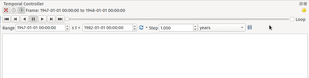
この機能は Natural resources Canada Contract: 3000720707 によって資金提供されました
この機能は`Nyall Dawson <https://github.com/nyalldawson>`__ によって開発されました。
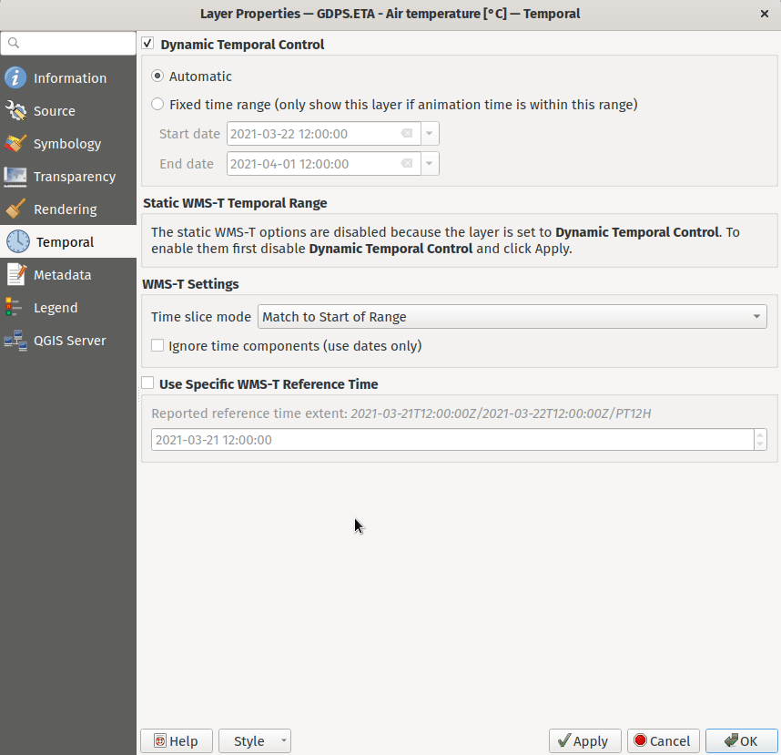
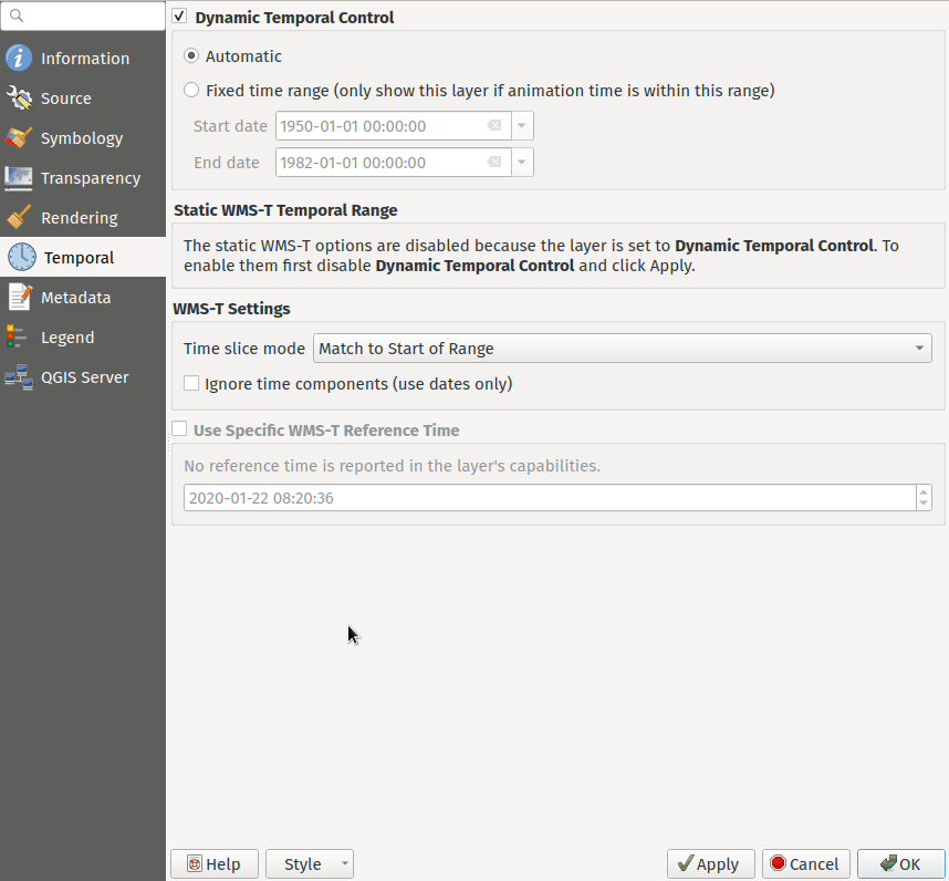
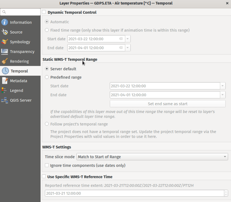
機能: 改良されたWMS-Tの設定
WMS-Tの設定が簡素化され、一部のプロバイダで目的の時間を選択しやすくするためのコントロールが導入されました。
次の成果を達成するために変更が行われました:
設定の各項目が何を制御するかを明確で正確にします
様々な設定間の相互作用と関係をより明確にします
レイヤが時系列コントローラによって制御されるか、設定が静的なWMS-Tレイヤに関連しているかに関係なく、どの設定が適用されるかを明示的にします
日付の範囲ではなく、非連続な日時インスタンスを公開するサーバは、有効な日付を手動で入力する必要がなくなるように、コンボボックスが提供されます
利用可能な日付の範囲を公開するサーバの設定の例:
利用可能な日時インスタンスのリストのみを公開するサーバの設定の例:
この機能は Natural resources Canada Contract: 3000720707 によって資金提供されました
この機能は`Nyall Dawson <https://github.com/nyalldawson>`__ によって開発されました。
ツール
機能: Nominatimジオコーディングの統合
Nominatimジオコーダーは、自由な発想でQGISにネイティブに統合されました! QGISは、Nominatimロケータフィルタと、バッチジオコーディングロケーションのための「バッチNominatimジオコーディング」プロセシングツールを提供しています。
Nominatimロケータフィルタ
QGISロケータバーウィジェット(デフォルトでは、左下隅の検索バーCTRL+K)は、プレフィックス'>'を使用してNominatimジオコード検索をサポートするようになりました。
ユーザーは、ロケータで形式 > 検索文字列 を使用して場所を検索でき、結果の選択肢が表示されます。検索結果を選択すると、キャンバスの範囲がその場所に再配置されます。
Nominatimジオコーディング
さらに、新しい「Nominatimジオコーディング」アルゴリズムがQGISプロセシングツールボックスのベクタツールの下に追加され、一度に複数の場所をジオコーディングできるようになりました。
Nominatimは、OpenStreetMapプロジェクトからのデータを利用するジオコーディングサービスです。使用制限とレート制限(1秒あたり1クエリ)は、OpenStreetMap Foundation(OSMF)の使用ポリシーに沿って適用され、データはODblライセンスの条件の下で提供されます。さらに、Nominatimサービスへのクエリには、テレメトリ情報が含まれる場合があります。
この素晴らしいジオコーダーサービスをデフォルトで提供することは、OSMFの寛大さと参加なしには実現できませんでした。
この機能は、Mathieu Pellerin によって開発されました
ユーザーインターフェース
機能: プロセシング履歴ダイアログの改善
The processing's history dialog has had a series of user interface improvements, including regrouping of algorithms in meaningful folder structures and making use of individual algorithm icons. Searching for that algorithm you ran last week has never been as easy!
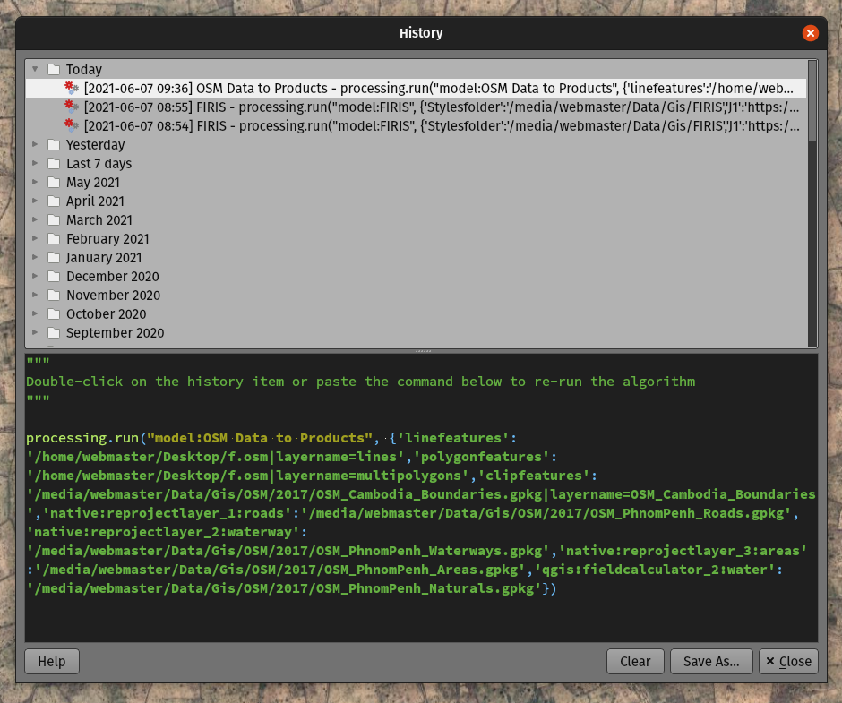
この機能は Mathieu Pellerin によって開発されました
機能: 式ビルダダイアログのマップレイヤアイコン
The expression builder dialog now displays map layer icons next to the list of layers under the 'Map Layers' parent group. This speeds up skipping through the list and provides additional context.
この機能は Mathieu Pellerin によって開発されました
機能: SVG ブラウザのフィルタリング
The SVG browser interface now supports simple text-based filtering, allowing users to filter the available SVG images based on a given search string.
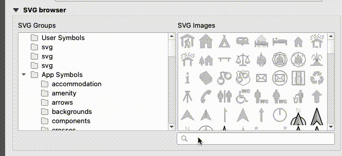
この機能は Denis Rouzaud によって開発されました
シンボロジ
Feature: Interpolated line symbol layer type for vector layers
QGIS provides a new "Interpolated Line" symbol layer type, which results in the rendering of a color and/ or width varying line.
This symbol is highly configurable and allows users to associate attributes or expressions to each line extremity or curve, amongst other configuration options. Values are interpolated along the line string between extremities. Color is configured with a color ramp shader widget.
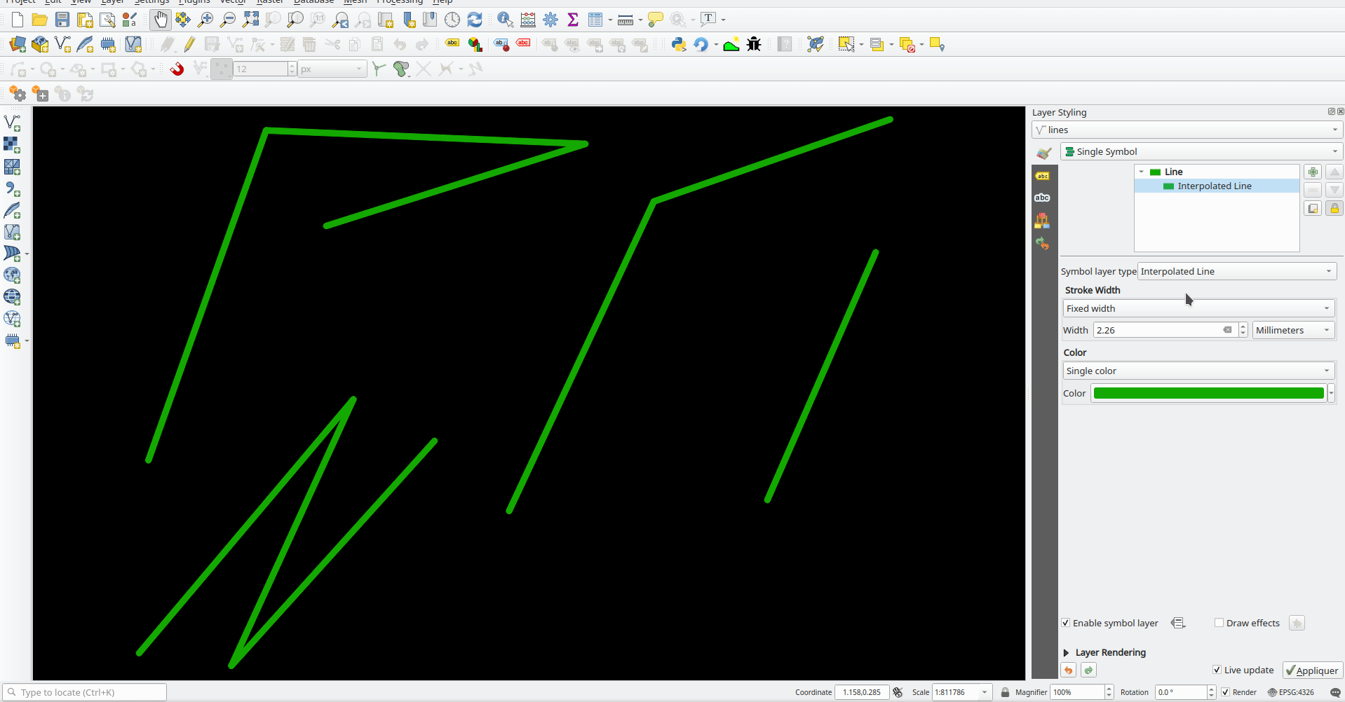
この機能は Lutra Consulting によって資金提供されました
この機能は Vincent Cloarec によって開発されました
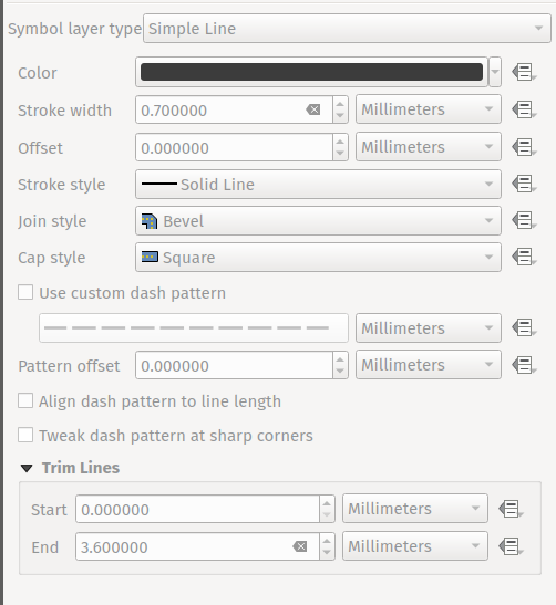
Feature: Trim the simple line symbol
単純なラインシンボルの開始と終了をトリミングするオプションが追加され、ユーザーが設定した距離でラインレンダリングがラインの最初と最後のセクションをトリミングできるようになりました。輸送ルートなど、ライン図形の開始位置または終了位置に配置されたマーカーシンボルレイヤーとラインレイヤーが重ならないようにする複雑なシンボルを作成する場合に便利です。トリム距離は、線全体の長さのパーセンテージを含むさまざまな単位をサポートし、データ定義プロパティとして構成することもできます。
A sample gallery of this functionality in use:
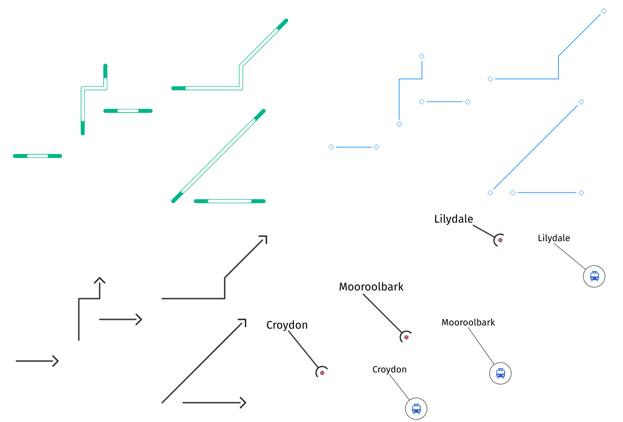
この機能は`Nyall Dawson <https://github.com/nyalldawson>`__ によって開発されました。
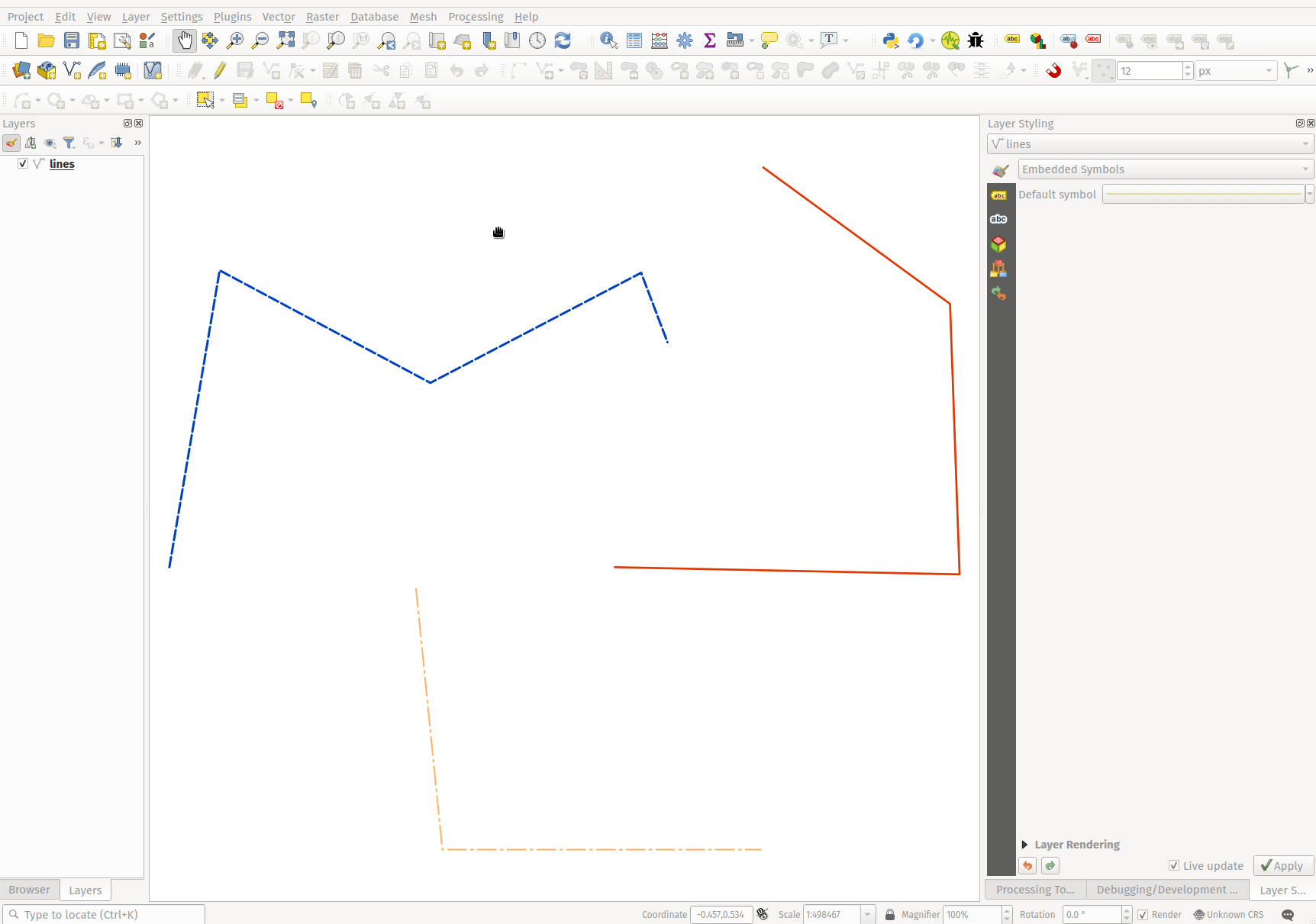
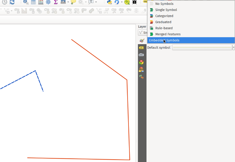
Feature: New "Embedded styling" renderer with OGR feature styles support
A new "Embedded styling" renderer has been added which exposes OGR feature styles, allowing QGIS to automatically symbolize data from certain datatypes which have integrated style information, such as KML or TAB files.
This feature implements QEP-209
Support should extend automatically to all GDAL drivers which implement the OGR feature style API.
Currently only supports line symbol conversion, but point and polygon symbol support is under development.
This functionality also supports the direct conversion of embedded symbol renderers into categorized or rule-based renderers. This enables QGIS to automatically create categories or rules which define symbology based on the relevant feature IDs:
この機能は QGIS Denmark user-group によって資金提供されました
この機能は`Nyall Dawson <https://github.com/nyalldawson>`__ によって開発されました。
機能: 楕円マーカーの新しい形状と両端スタイル
Several new shapes - semi arc and arrow signs - were added to the ellipse marker symbol layer, as well as a setting to modify the cap style for stroke-only ellipse shapes.
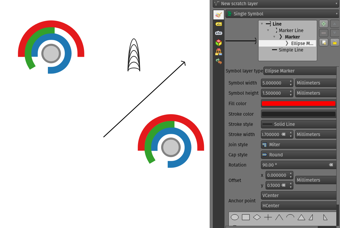
この機能は Mathieu Pellerin によって開発されました
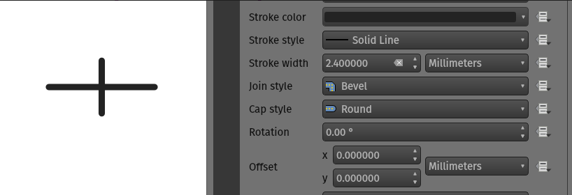
機能: シンプルマーカーに両端スタイルを設定
QGIS now allows for the pen cap (or line ending) style to be set for simple marker symbol layers, which is useful for the stroke-only symbols like cross and arrowhead markers, where it's beneficial to allow the use of round caps instead of square caps.
この機能は`Nyall Dawson <https://github.com/nyalldawson>`__ によって開発されました。
Feature: Allow pen cap style to be set for ellipse marker symbol layers
Ellipse markers now also include support for modifying the pen cap (line ending) styles
この機能は、Mathieu Pellerin によって開発されました
機能: ポリゴンリング @geometry_ring_num 変数
A new variable, @geometry_ring_num, has been added for data-defined styling when rendering polygon rings. The variable is available whenever a polygon outline is being rendered, such as a simple line or marker line. This data-defined property will be set to 0 for the exterior ring, and increment accordingly (1, 2, 3... etc) for successive interior rings.
この機能は`Nyall Dawson <https://github.com/nyalldawson>`__ によって開発されました。
ラベリング
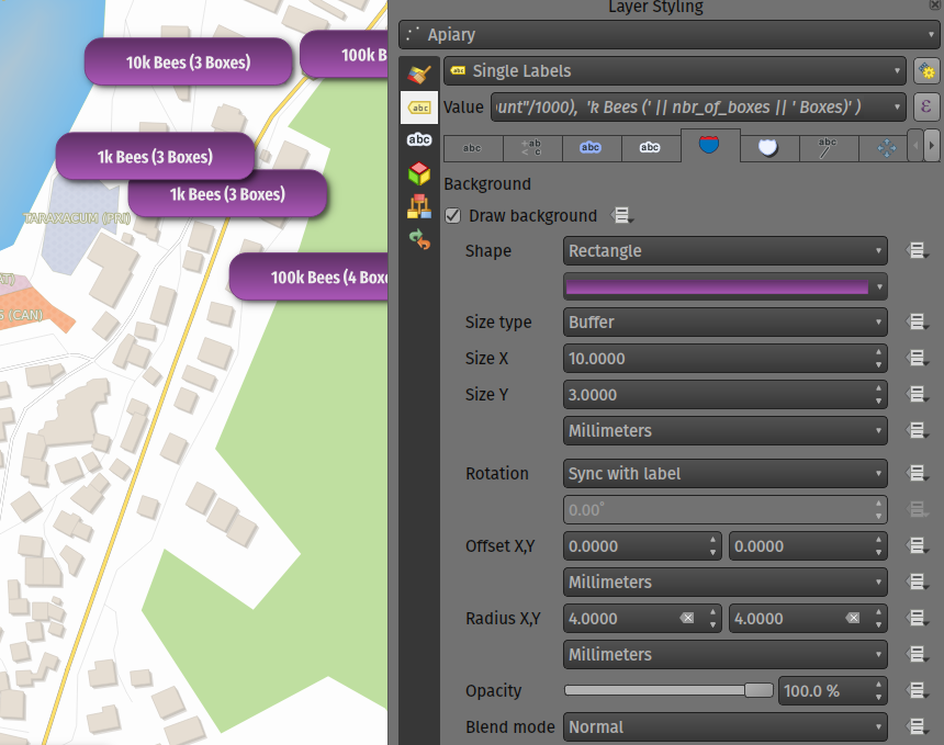
Feature: Fill symbols for label background shields
Label shields can now use fill symbols for the rectangle, square, circle, and ellipse shapes.
This extends beyond the previously available ability for these shields to utilize simple fill and stroke and grants the ability to leverage the complete symbology capabilities of QGIS for shield rendering, including the utilization of "saved styles".
この機能は、Mathieu Pellerin によって開発されました
Feature: Blending mode settings for label callouts
Label callouts can now leverage the advanced blending modes from QGIS
この機能は、Mathieu Pellerin によって開発されました
Feature: Anchor line labels by entire line
In previous versions, when an anchor position for a line label was calculated, QGIS would only consider the visible extent of the feature. This affected the expected label position in some cases, and a new "Use Entire Line" setting allows users to configure the behavior according to their needs, so that the entire feature may be considered before label placement rather than just the portion of a feature that is currently visible.
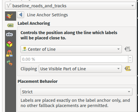
この機能は Stadt Zürich によって資金提供されました
この機能は`Nyall Dawson <https://github.com/nyalldawson>`__ によって開発されました。
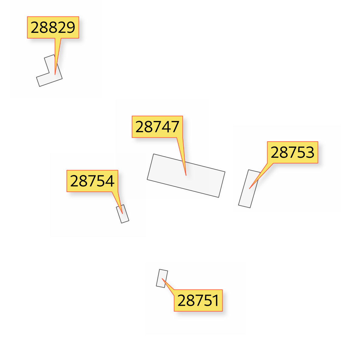
Feature: Balloon callout corner radius
バルーンコールアウトスタイルは、「コーナー半径」オプションを導入することで丸みを帯びたコーナーをサポートするようになり、視覚的に心地よいデザインを簡単に作成できるようになりました。
この機能は`Nyall Dawson <https://github.com/nyalldawson>`__ によって開発されました。
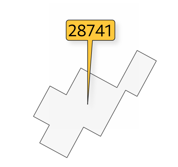
Feature: Balloon (speech bubble) callouts
A new "balloon", or speech bubble, callout style is provided for labels.
この機能は SLYR によって資金提供されました
この機能は`Nyall Dawson <https://github.com/nyalldawson>`__ によって開発されました。
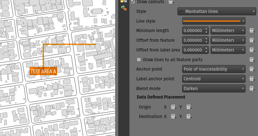
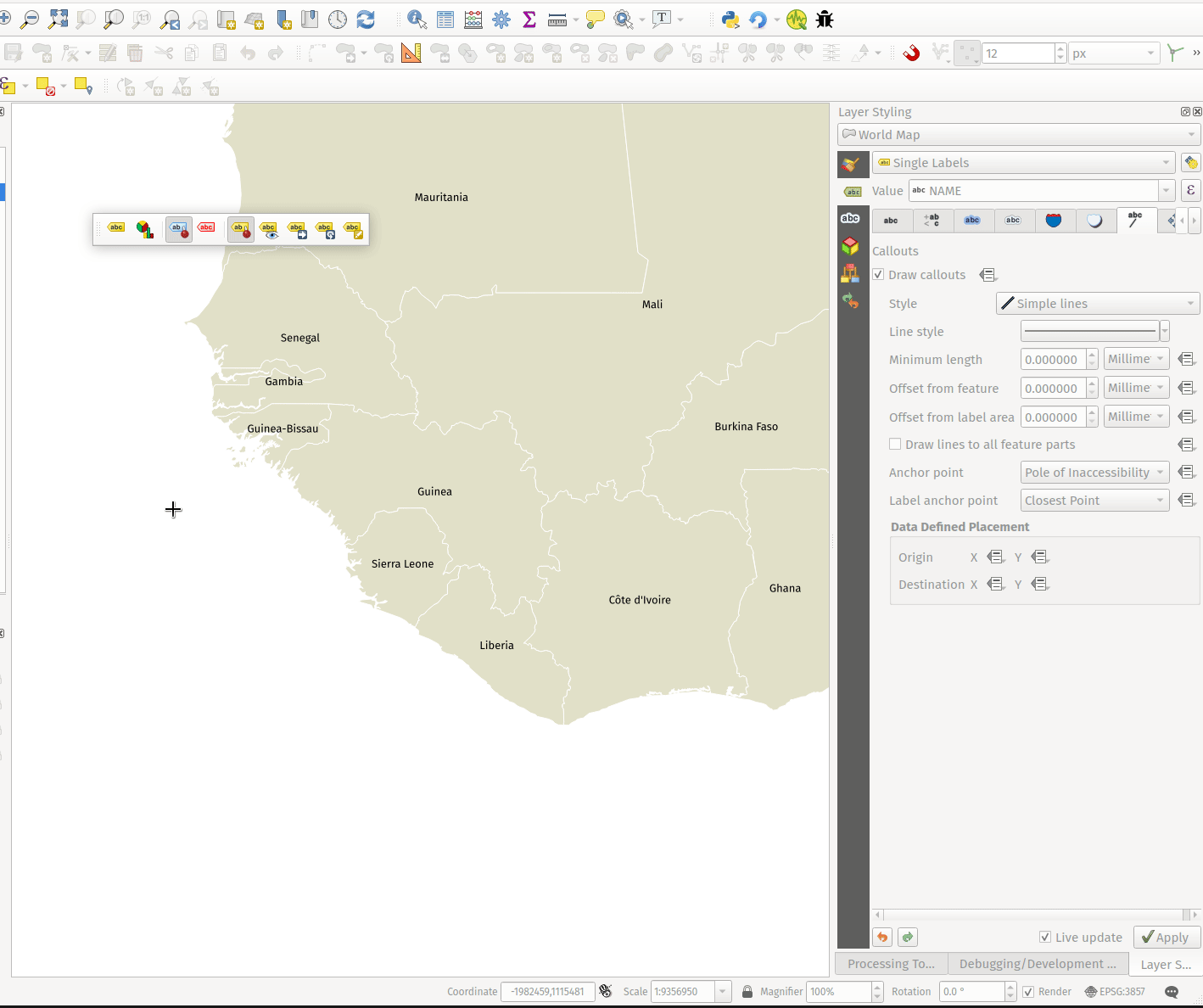
Feature: Curved line callout style
A new "Curved Line" callout style has been provided for creating cartographically pleasing curved line callouts between the labels and features
オプション:
Selecting a specific curve orientation (clockwise or counterclockwise)
Automatic orientation option which determines optimal orientation for each individual label
Control over the amount of curvature applied to the callout lines.
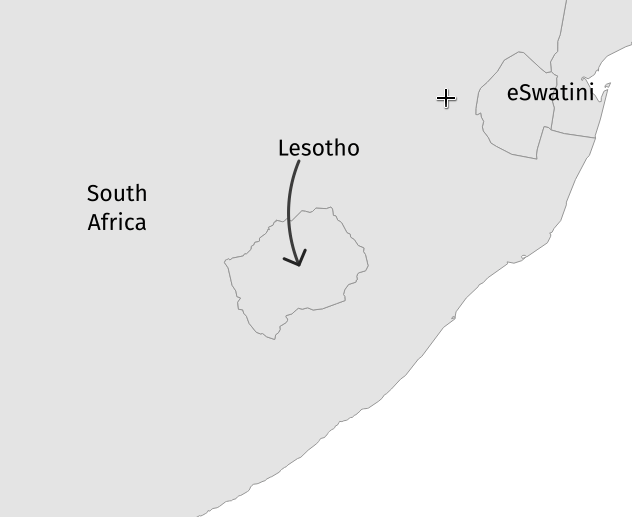
この機能は`Nyall Dawson <https://github.com/nyalldawson>`__ によって開発されました。
Feature: Highlight pinned callout start or end points
「ピン留めされたラベルを表示」オプションが有効になっている場合、QGISはピン留めされたコールアウトの開始点または終了点も強調表示するようになりました。これにより、ユーザーは、自動的に配置されたコールアウトポイントと比較して、手動で配置されたコールアウトポイントをすぐに確認できます。
この機能は`Nyall Dawson <https://github.com/nyalldawson>`__ によって開発されました。
Feature: Auto-creation of callout auxiliary fields
QGIS now automatically manages the creation of callout auxiliary fields when attempting to move a callout start or end point interactively, making the user experience for moving a callout follow the exact same behavior as that of moving a label, preventing the system from forcing users to create auxillary fields in advance.
この機能は`Nyall Dawson <https://github.com/nyalldawson>`__ によって開発されました。
Feature: Callout snapping
When interactively moving a callout line, holding the shift button will now cause the callout to snap angles at increments of 15 degrees
この機能は`Nyall Dawson <https://github.com/nyalldawson>`__ によって開発されました。
Feature: Toggle label layers shortcut
レイヤーパネルのベクターレイヤーのコンテキストメニューに、ラベル付けを切り替えるショートカットアクションが追加されました。これにより、ラベル構成を失うことなく、ラベルをすばやくオンまたはオフに切り替えることができます。レイヤーにラベリングが構成されたことがなく、アクションがチェックされている場合、QGISはデフォルトのパラメーターを使用してレイヤーに単純なラベリング構成を適用しようとします。
この機能は Natural resources Canada Contract: 3000720707 によって資金提供されました
この機能は`Nyall Dawson <https://github.com/nyalldawson>`__ によって開発されました。
Feature: Data defined callout start and end points
Label callout lines can now have data-defined starting and ending points, useful for manual control of the exact placement for individual callout lines.
この機能は`Nyall Dawson <https://github.com/nyalldawson>`__ によって開発されました。
Feature: Allow callouts to be interactively moved using the Move Label tool
This change allows the interactive "Move labels" tool to also move callout endpoints, whenever the callout has data-defined origin or destination fields set.
この機能は`Nyall Dawson <https://github.com/nyalldawson>`__ によって開発されました。
点群
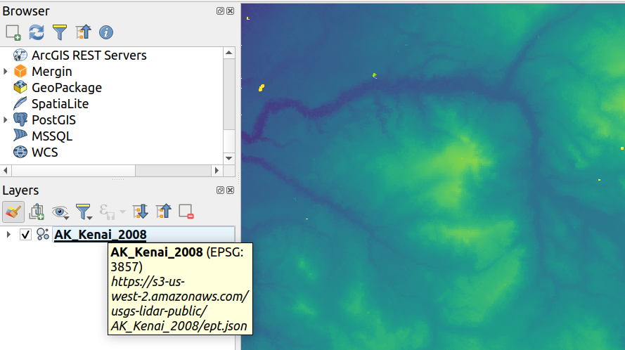
Feature: Support for remote datasets (EPT)
EPT形式 に処理されているポイントクラウドデータセットは、ラスター/ベクタータイルの動作と同様に、リモートHTTP(S)サーバーからロードできます。この方法で、大きな点群データセットには最初にLAS / LAZファイルとしてダウンロードしなくてもアクセスできます。 EPT形式はタイリングとストリーミング用に最適化されているため、QGISでは現在のビューおよび解像度での表示に必要な少量のデータのみをダウンロードします。これは、2Dビューと3Dビューの両方で機能します。
LAS/LAZ形式の点群データセット をお持ちの場合は、 Entwine または Untwine を使用するとEPT へと変換できます(QGISにも同梱)。
How to use: in Data Source Manager > Point Cloud tab > select "Protocol" as the source type and enter URL of the dataset (normally ending with "ept.json").
You can test with USGS LiDAR data - just use the link from "EPT" column from one of the datasets. Some example endpoints include:
By the way, every point cloud dataset that QGIS loads is first processed to EPT (look for "ept_XXX" sub-folder where your original data is located), so it is possible to just copy that "ept_XXX" folder to a HTTP(S) server and you are ready to use this feature.
この機能は Hobu によって資金提供されました
この機能は Belgacem Nedjima (Lutra Consulting) によって開発されました
印刷レイアウト
Feature: "Convert to Static Text" option
When using dynamic, or expression-based labels, users may now select the "Convert to Static Text" option which has been added to the dropdown menu next to "Insert/Edit Expression…", in the layout label properties widget.
This option will evaluate and replace any dynamic parts of a label's contents with their current values.
This provides an easy way to convert dynamic labels to static ones, so that users can manually tweak the results when needed.
この機能は`Nyall Dawson <https://github.com/nyalldawson>`__ によって開発されました。
Feature: Improvement to XYZ layers previewed in map items
Handling of XYZ layers previewed in layout map items has been improved to ensure that their tile zoom levels match those of the exported layout while zooming in and out in the layout designer dialog. Users can now more easily refine the placement of their items (labels, legend, images, etc.) against a map preview that better matches the targeted output.
この機能は Kanton Zug - Amt für Raum und Verkehr (ARV) によって資金提供されました
この機能は Mathieu Pellerin によって開発されました
計算式
Feature: length3D Function
A "length3D" function has been added for returning the 3D length of a LineGeometry type geometry. This calculates the cartesian 3D length of a geometry line object. If the geometry is not a 3D line object, it returns its 2D length.
この機能は`Nyall Dawson <https://github.com/nyalldawson>`__ によって開発されました。
Feature: Extended array expression functions
The following array expressions were added:
array_count
array_prioritize
array_replace
この機能は Canton of Luzern によって資金提供されました
この機能は Damiano Lombardi によって開発されました
Feature: MIME Type expression function
The new mime_type( bytes ) expression function returns the MIME Type, or Media type, of an input bytes object
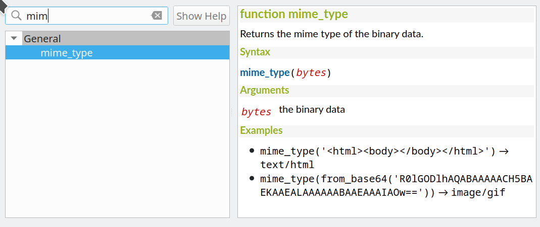
この機能は Alessandro Pasotti によって開発されました
デジタイズ
Feature: Select attributes from the largest geometry when merging
A button to select attributes from the largest geometry has been added to the confirmation dialogue when using the merge features editing tools for polygon and line layers.
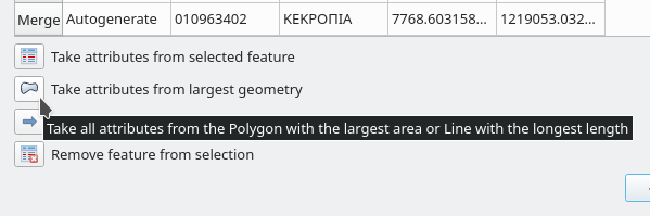
この機能は Stefanos Natsis によって開発されました
Feature: Streaming digitizing mode
When streaming digitizing mode is active, points are automatically added following the mouse cursor movement, providing a "freehand drawing" type experience.
Using the "R" key during digitizing operations will toggle streaming digitizing and normal (or circular string) digitizing.
Works with multiple map tools, including creating new line or polygon features, add ring, add part, reshape, split features, split parts, and more.
この機能は Natural resources Canada Contract: 3000720707 によって資金提供されました
この機能は`Nyall Dawson <https://github.com/nyalldawson>`__ によって開発されました。
Feature: New "Line Endpoints" snapping option
When enabled, this snapping mode snaps to the beginning or end vertex of lines only. When snapping to a polygon layer, only the first vertex in rings will be snapped to.
この機能は Natural resources Canada Contract: 3000720707 によって資金提供されました
この機能は`Nyall Dawson <https://github.com/nyalldawson>`__ によって開発されました。
機能: ポリゴンによる頂点の選択
Users can now use the ALT button to select vertices by polygon whilst digitizing.
これにより、頂点ツールを使用して特定の頂点を選択するためのユーザーエクスペリエンスが向上し、SHIFTまたはCTRL関数を使用して現在の選択に頂点を追加および削除する複数のパスの必要性が減少します。
This also reduces the need to creatively rotate the map canvas in order to align vertices for selection, and provides an enhanced editing process such as for selecting the vertices of a curved road along a single side only.
This function supports the following usage operations:
Alt+click using the vertex tool to start digitizing a polygon.
Each subsequent click adds a new vertex to the rubberband polygon.
Backspace/ delete removes last added rubberband vertex.
Esc cancels the polygon selection mode, as does backspace/ deleting all of the rubberband's vertices.
Right-click finalizes the polygon digitizing and selects all vertices within the rubberband polygon.
この機能は Stefanos Natsis によって開発されました
データ管理
Feature: Layer tree warning icon for layers with CRS inaccuracies
A new "Show CRS accuracy warnings for layers in project legend" is provided which, when checked, will display a new warning icon identifying any layers with a CRS which is identified as having accuracy issues.
Examples of low-accuracy layers might include those with a dynamic CRS with no coordinate epoch available, or a CRS based on a datum ensemble with accuracy that is found to exceed the user-set limit.
This option is disabled by default, and designed for use in engineering, BIM, and other industries where inaccuracies of meter/submeter level are very dangerous.
この機能は`Nyall Dawson <https://github.com/nyalldawson>`__ によって開発されました。
Feature: Basic support for dynamic CRS coordinate epoch
Basic support for the coordinate epoch of dynamic (not plate fixed) CRS has been added in line with relevant updates to GDAL.
QGIS has added support for respecting the source or destination coordinate epoch when transforming to or from a dynamic CRS.
If a dynamic CRS to dynamic CRS transformation at different epochs is attempted, which is not currently supported by PROJ, a user-facing warning message will be shown advising them that the results may be misleading and should not be used for high accuracy work.
この機能は`Nyall Dawson <https://github.com/nyalldawson>`__ によって開発されました。
Feature: Projection information improvements
Various improvements have been made to the handling and representation of projection information in QGIS, including:
The addition of an API to retrieve PROJ operation details for CRSes
The ability to show extended information about a layer's CRS in the layer properties info tab, including accuracy warnings
The addition of a
@map_crs_projectionvariable, for retrieving a friendly name of a map's projection (e.g. "Albers Equal Area")
この機能は`Nyall Dawson <https://github.com/nyalldawson>`__ によって開発されました。
Feature: Datum ensemble CRS warnings
QGIS now shows a warning in the projection selection widget when a CRS based on a datum ensemble is selected, warning the user that there's an inherent lack of accuracy in the selected CRS.
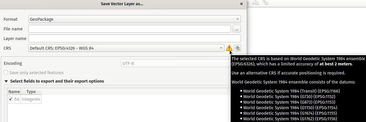
この機能は`Nyall Dawson <https://github.com/nyalldawson>`__ によって開発されました。
Feature: Persist layer metadata in vector file exports
A "persist layer metadata" checkbox has been added to the export vector file dialog. When checked, any layer metadata present in the source layer will be copied and stored in the destination file.
This functionality is enabled by default and ensures that metadata is properly transferred over to newly created items, which is especially effective when utilizing the GPKG format.
この機能は`Nyall Dawson <https://github.com/nyalldawson>`__ によって開発されました。
Feature: Layer notes
QGIS now supports "layer notes", which can be created via the "Add Layer Notes" action in the layer context menu.
These notes are saved per layer, per project. They can be used as a place to store important messages for project users, such as to-do lists, processing or management instructions, or any other arbitrary text-based metadata.
A notepad indicator icon in the layers panel identifies layers that have notes attached. Clicking the notes indicator icon will open the note for editing.
この機能は QEP-206 において議論されました
These notes may be copied and pasted using the traditional copy/ paste methodology for transferring styles between layers in QGIS.
Layer notes are also supported by and stored within QML (QGIS Style) and QLR (QGIS Layer Definition) files.
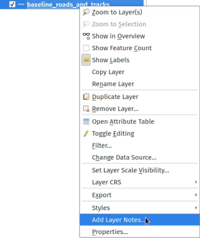
この機能は Alta Ehf によって資金提供されました
この機能は`Nyall Dawson <https://github.com/nyalldawson>`__ によって開発されました。
Feature: Automatically load .shp.xml metadata
QGISでは、.shp.xmlサイドカーファイルを使用して保存されたESRIメタデータを自動的にロードして変換するようになりました。シェープファイルデータがロードされ、これらのメタデータファイルが存在する場合、それらは自動的にロードされ、それに応じて使用可能なレイヤーメタデータが入力されます。
この機能は`Nyall Dawson <https://github.com/nyalldawson>`__ によって開発されました。
Feature: Automatically translate layer data from ESRI Filegeodatabases to QGIS layer metadata
.gdbファイルからデータをロードするとき、QGISは自動的に元のESRIメタデータの可能な限り多くをQGISメタデータに変換しようとするので、すぐに使用できるようになります。
この機能は North Road / SLYR によって資金提供されました
この機能は`Nyall Dawson <https://github.com/nyalldawson>`__ によって開発されました。
Feature: Read field domains from datasets
For formats that support the embedded definition of field domains (currently GPKG and GDB), QGIS automatically converts the embedded field domain over to the equivalent QGIS editor configuration for the field.
これは、コード化されたフィールドドメインを持つGPKG / GDPが、正しいバリューマップウィジェット構成をそのままにしてQGISに自動的にロードされるため、ユーザーには生のコードではなくフィールド値の説明が表示されることを意味します。範囲(最小/最大)タイプのドメインを持つフィールドは、フィールドの範囲ウィジェットにも変換されます。
この機能は North Road によって資金提供されました
この機能は`Nyall Dawson <https://github.com/nyalldawson>`__ によって開発されました。
Feature: Allow loading GPKG layers with GEOMETRY type
GeoPackage supports layers with a generic "geometry" type, with the QGIS release 3.20 it is now possible to load them and specify the requested geometry type on load, just like with PostGIS.
この機能は Marco Bernasocchi (OPENGIS.ch) によって開発されました
Feature: Offline editing support for string list and number list field types
PostGIS users rejoice: offline editing got a bit smarter and can now handle string list and number list field types.
この機能は Mathieu Pellerin によって開発されました
フォームとウィジェット
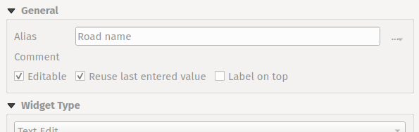
Feature: Per-field usage of last values for newly created features
新しい地物を作成するときに最後に入力したフィールド値を再利用するかどうかの拡張制御が提供されました。この機能は、各レイヤーの個々の属性フィールドごとに個別に制御できるようになったためです。
これまで、この機能は、新しい地物を作成するときにQGISセッション中にすべてのレイヤーのすべてのフィールド値が記憶されて再利用されるようにするグローバルオプションを使用して構成されていました。
これにより、フォームの動作をより細かく制御できます。再利用が望ましい値もあれば、クリアしたり、式に基づくデフォルト値に設定するべき値もあります。
この機能は`Nyall Dawson <https://github.com/nyalldawson>`__ によって開発されました。
Feature: JSON View widget
New view widget to display JSON data in a user friendly way. Data can be displayed as syntax highlighted text or as a tree.
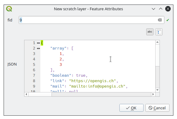
この機能は Canton of Solothurn によって資金提供されました
この機能は Damiano Lombardi によって開発されました
レイヤ凡例
Feature: Vector "label" legend entries
QGIS now supports adding legend entries for layer labels, which will display the font style and labeling classes for vector features.
This provides a legend entry that allows users to explicitly identify features by label style, even when no feature symbology is used.
Control of this behavior is made accessible by adding a "show label legend" option to the legend tab of the vector layer properties.
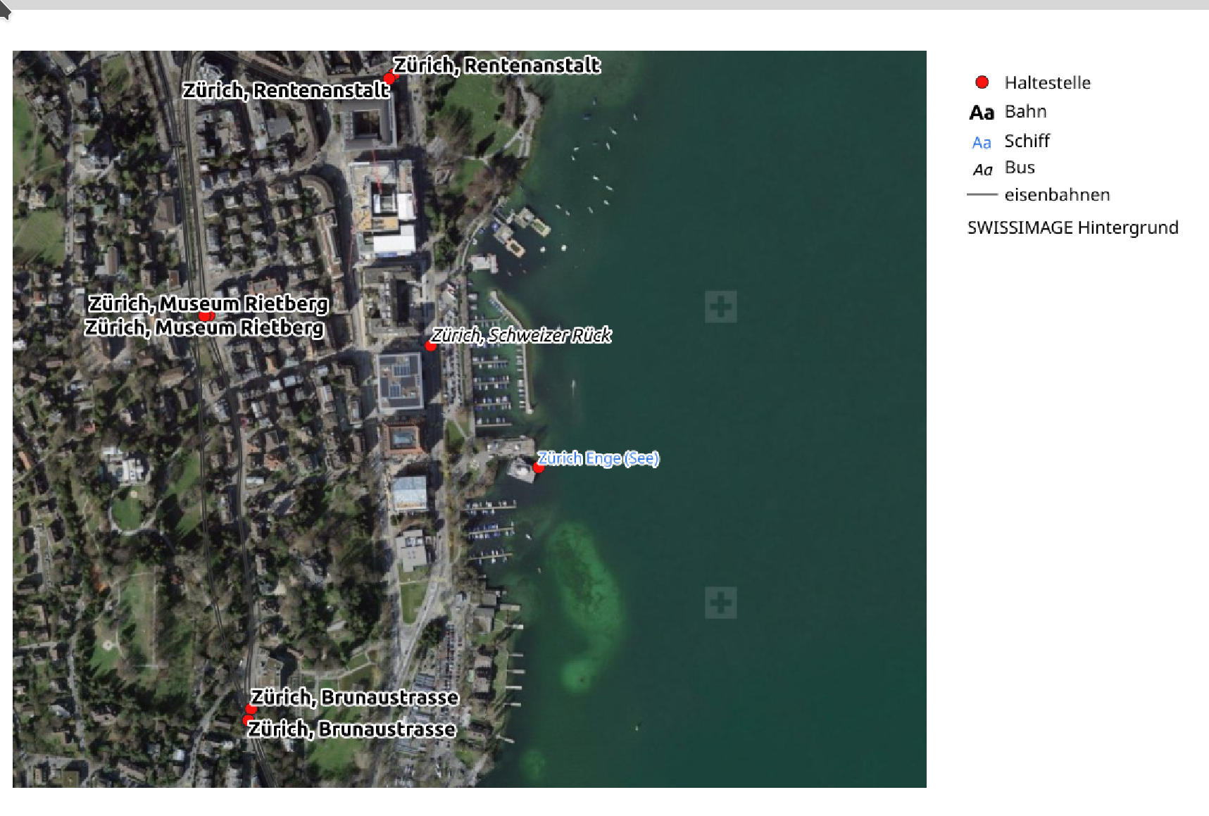
この機能は Canton of Glarus によって資金提供されました
この機能は mhugent によって開発されました
プロセシング
Feature: Add option to save layer metadata to Package Layers algorithm
This additional option enriches the Package Layers algorithm and will copy the source layer metadata into the geopackage, so that it will be used as the default metadata for the layer.
この機能は`Nyall Dawson <https://github.com/nyalldawson>`__ によって開発されました。
Feature: Raster Layer Properties Algorithm
This algorithm retrieves basic raster layer properties such as the size in pixels, pixel dimensions (map units per pixel), number of bands, and no data value.
これは、既存のラスターのピクセルサイズをGDALラスターアルゴリズムに渡すなど、モデル内の他のアルゴリズムへの入力値として使用するこれらの有用なプロパティを抽出する手段として使用することを目的としています。
この機能は`Nyall Dawson <https://github.com/nyalldawson>`__ によって開発されました。
Feature: Improved rasterize operation with 3D support
The rasterize (vector to raster) GDAL process now supports 3D data, in that it now includes the possibility to use the Z value (elevation) of a feature to extract burn values.
このオプションを使用すると、地物の「Z」値から書き込み値を抽出する必要があることを示します。ポイントとライン(各セグメントに沿った線形補間)で機能します。ポリゴンの場合、地物がフラットである(つまり、すべての頂点に同じZ値が含まれている)場合にのみ適切に機能します。
この機能は talledodiego によって開発されました
Feature: Save selected option for Package Layers Algorithm
The Package Layers Algorithm was modified to support saving only selected features
この機能は Stefan Conrads によって開発されました
Feature: Log levels for processing context
A new log level property has been added to QgsProcessingContext
This allows algorithms to tune their output based on the logging level.
The qgis_process command line operation has been granted a --verbose switch to enable verbose log output.
この機能は Natural resources Canada Contract: 3000720411 によって資金提供されました
この機能は`Nyall Dawson <https://github.com/nyalldawson>`__ によって開発されました。
Feature: Geometry snapper rework offers major speed boost
This development cycle saw a rework of the inner workings of QGIS' geometry snapper algorithm, which has led to a significant speed boost. Datasets which could take over 10 minutes to process now take less than 10 seconds.
この機能は SwissTierras Colombia によって資金提供されました
この機能は Mathieu Pellerin によって開発されました
Feature: Add a last_value function to the aggregate algorithm
The aggregate processing tool now includes a last_value aggregation function, which is especially useful when working with input data that has meaningful ordering.
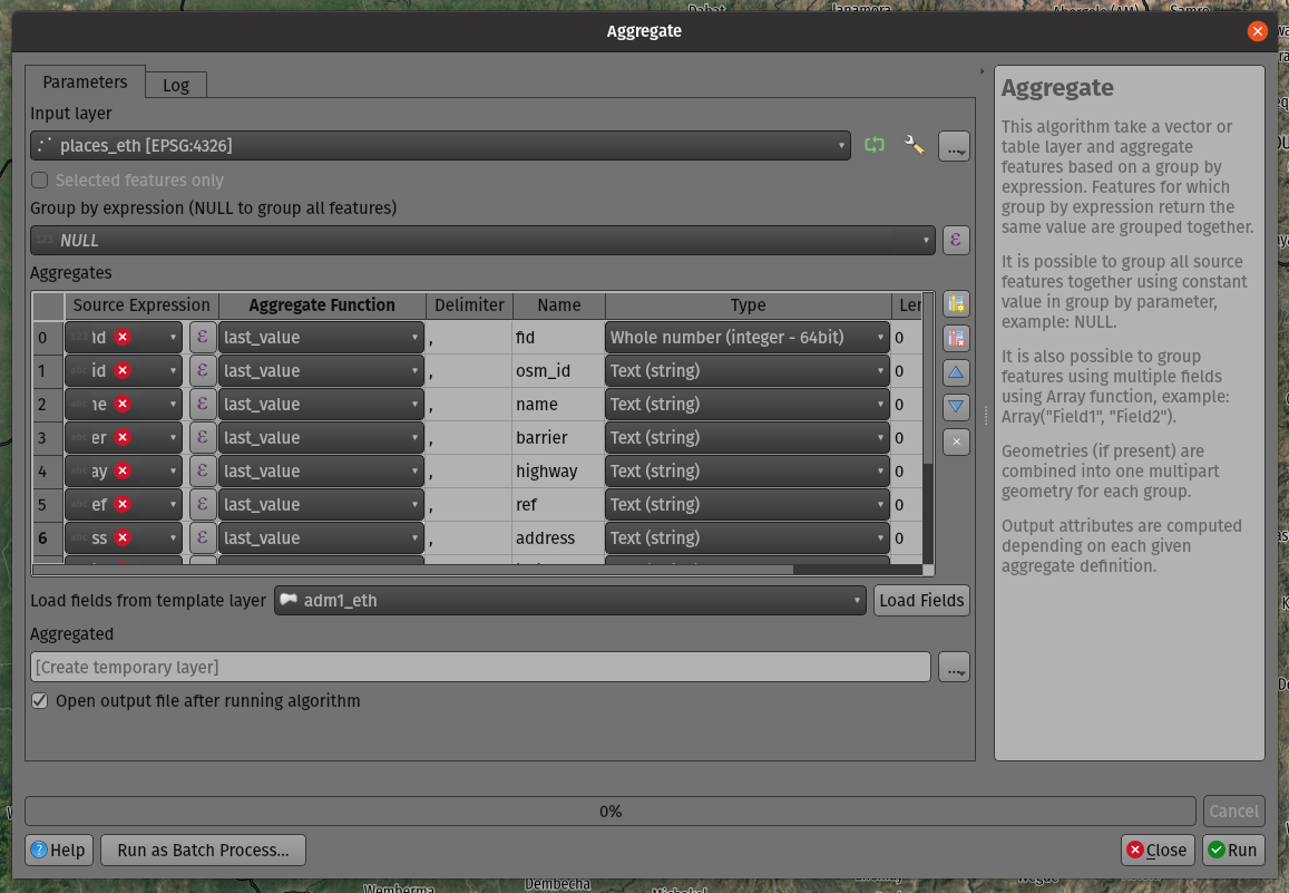
この機能は Mathieu Pellerin によって開発されました
アプリケーションとプロジェクトのオプション
Feature: Add global option to disable monitoring of directories
Allows users to manually opt-out of monitoring directories in the browser by default, and also provides a mechanism for enterprise installs to disable this potentially unwanted behavior.
この機能は`Nyall Dawson <https://github.com/nyalldawson>`__ によって開発されました。
Feature: APIs for export and import of XML authentication configurations
QGISはQGIS認証マネージャでエクスポートおよびインポート機能を提供するようになりました。この機能は、ユーザーインターフェイスではまだ公開されていません。 OAuth2など、多数の複雑な認証構成をオプションで暗号化するか、プレーンテキストで保存して、認証管理ワークフローを強化できます。
この機能は、Mathieu Pellerin によって開発されました
ブラウザ
Feature: Custom icon colors for folders in browser
QGIS now allows users to set a custom icon color for different folders in the browser. This effectively allows users to "tag" folders, which aids in the rapid navigation of complex folder structures in the browser.
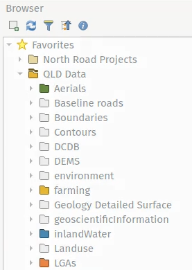
この機能は`Nyall Dawson <https://github.com/nyalldawson>`__ によって開発されました。
Feature: OWS Group removed from the QGIS Browser
The non-functional and redundant "OWS" Group has been removed from the QGIS Browser panel.
この機能は Loïc Bartoletti によって開発されました
データプロバイダ
Feature: Add support for integer, real and integer64 list data types in OGR
Additional list field types have been added to the OGR driver for supported data types, such as Geojson.
この機能は`Nyall Dawson <https://github.com/nyalldawson>`__ によって開発されました。
Feature: Extend vector layer read capabilities to other layer types
メタデータからレイヤの範囲を読み取るなど、QGISがレイヤのメタデータ情報にアクセスする機能は以前はベクタレイヤに制限されていましたが、この機能は、ラスタ、点群など、他のさまざまなレイヤタイプを含むように拡張されました。
この機能は Ifremer によって資金提供されました
この機能は rldhont によって開発されました
QGISサーバー
Feature: External layer opacity
Opacity control support for external/ remote layers served by QGIS Server
この機能は mhugent によって開発されました
Feature: Configurable Service URL
GetCapabilities応答の結果を改善するために、特にQGISプロジェクト構成内のさまざまなフィールドに入力する必要なしに、追加のオプションがQGISサーバーに追加されました。これらの更新により、環境変数によって、またはプロキシからヘッダーを提供することによって、多くのオプションを設定することもできます。
The following options have been added and will be resolved by the server in the following order:
Value defined in the project per service.
The
<service>_SERVICE_URLenvironment variable.The
SERVICE_URLenvironment variable.The custom
X-Qgis-<service>-Service-Urlheader.The custom
X-Qgis-Service-Urlheader.Build from the standard
Forwardedheader.Build from the pseudo standard
X-Forwarded-HostandX-Forwarded-Protoheaders.Build from the standard
Hostheader and the server protocol.Build from the server name and the server protocol.
この機能は Stéphane Brunner によって開発されました
注目すべき修正
機能: Even Rouault によるバグ修正
バグの表題 |
URL (if reported, Github) |
URL Commit (Github) |
3.16 backport commit (GitHub) |
|---|---|---|---|
compiler warning in QgsMeshDatasetGroupStore::readXml() |
未報告 |
N/A |
|
QGIS Crashes with GDAL 3.3 |
|||
Data corrupted when deleting field in a (specific) geopackage layer |
|||
PyQGIS: WMS-T layer uri without timeDimensionExtent in it crashes QGIS |
|||
Data Corruption: Failed GPKG OID/FID Over-write causes value to spill into next attribute column |
|||
"Split features" causes data loss |
|||
Foreign key constraints checks are ignored on GPKG |
Not appropriate |
||
Strange error message from SQL Query Composer in WFS client |
|||
WFS 1.1.0 ExceptionReport response handling : QGIS looks for 'exceptionCode' but in specifications it's 'code' attribute |
|||
Export selection from a large WFS layer fails |
|||
Long (?) WKT makes delimited text layer fail on 3.16 and 3.18 |
|||
Wrong SRS when reading a Postgis layer |
未報告 |
Not appropriate |
|
Mesh data in GRIB format from ERA5 |
|||
Two OGR provider filtered layers with same source dataset don't restore proper feature count / extent on project reload |
この機能は QGIS.ORG (through donations and sustaining memberships) によって資金提供されました
この機能は Even Rouault によって開発されました
機能: Alessandro Pasotti によるバグ修正
バグの表題 |
URL (if reported, Github) |
URL Commit (Github) |
3.16 backport commit (GitHub) |
|---|---|---|---|
Data Source Manager fails to derive exact 3D geometry type for GeometryZ PostGIS tables |
|||
Attribute table conditional formatting doesn't work when using $geometry is NULL |
Works for me |
||
QgsZonalStatistics.calculateStatistics() incomplete outputs |
|||
Bad Request on feed.qgis.org |
無関係 |
||
Server: WFS3/API Features - overlapping columns/content on data items as HTML pages |
|||
Datum transformation using custom gsb grid for WMS Layer in QGIS Server does not work |
無関係 |
||
Server: fix unreported QGIS_OPTIONS_PATH not really working for proj |
未報告 |
Not appropriate |
|
WFS cascade getfeatureinfo fails |
Works for me |
||
Server standalone: fix unreported project storage not supported with -p |
未報告 |
||
QGIS Server GetPrint: HIGHLIGHT_GEOM is not printed if map layers are configured to follow a map theme |
Risky |
||
Feature count is wrong when adding features from a table with features of mixed geometries |
Works for me |
||
Not all geometry types are found in PostGIS table with Spatial Type of Geometry |
Risky |
||
Icon not updated when saving a scratch layer |
未報告 |
||
Fix list of protocols in ssh custom configuration |
未報告 |
Not appropriate |
|
Crash with table set to Show Visible, joins, and left open as QGIS is quit |
Not appropriate |
||
"show label" is disabled in widget designer but label keeps displaying in attribute form if you use tabs in the Drag and-Drop Designer and the field widget was placed in any tab |
TODO |
||
Browser adds layers to projects with a leading space |
Not appropriate |
||
saveStyleToDatabase() bug when saving more than one layer to a GPKG |
Works for me |
||
Widget parameters not persistent for relations in D&D designer |
Not appropriate |
||
Rule-based rendering sometimes doesn't show all results |
Risky |
||
Fix unreported missing raster band stats in info panel |
未報告 |
||
Raster calculator does not create/store statistics for output rasters |
Not a priority |
||
Attribute Form Value Relation Doesn't Respect Column Default |
Works for me |
||
Attribute table in form view can display "ghost" attributes |
Not a priority |
||
PG identity default clause issue |
https://lists.osgeo.org/pipermail/qgis-user/2021-June/048983.html |
Not appropriate |
|
Pyqgis 3.18.3 error when adding wms layer |
TODO |
||
"Reuse last entered attribute values" slows creation of new features on large vector |
TODO |
||
Deleting "all other values" breaks date based categorise symbology |
|||
Fix documentation doctest builds |
無関係 |
この機能は QGIS.ORG (through donations and sustaining memberships) によって資金提供されました
この機能は Alessandro Pasotti によって開発されました
機能: Paul Blottiereによるバグ修正
バグの表題 |
URL (if reported, Github) |
URL Commit (Github) |
3.16 backport commit (GitHub) |
|---|---|---|---|
VERSION is now mandatory in WMS 1.3.0 for getmap requests |
未報告 |
||
WMTS GetCapabilities and axis order |
|||
Use the lowest version in wms negotiation |
Risky |
||
QGIS crashes adding a record to a memory ("scratch") layer table in some circumstances |
Works for me |
||
QGIS fails silently when an auxiliary layer cannot be created |
未報告 |
||
補助ストレージ情報を保管できません |
Risky |
||
WMS GetFeatureInfo on time enabled layer does not pass TIME parameter |
この機能は QGIS.ORG (through donations and sustaining memberships) によって資金提供されました
この機能は Paul Blottiere によって開発されました
機能: Denis Rouzaudによるバグ修正
バグの表題 |
URL (if reported, Github) |
URL Commit (Github) |
3.16 backport commit (GitHub) |
|---|---|---|---|
Widget parameters not persistent for relations in D&D designer |
無関係 |
||
Use a read-only line edit instead of combobox in relation reference doesn't allow to add a child from the parent |
too risky / not worth it |
||
no open-form in all layers feature locator filter (active filter has) + show form instead of error for geometry-less layers |
未報告 |
? |
|
Cannot add a polymorphic relations |
無関係 |
||
Filter expression from relation reference widget on attributes form, not working properly |
はい |
||
fix Picture layout element does not handle properly a non-existing filepath when provided with an expression |
|||
relations bug: zoom to child button disappears |
Works for me |
||
Value Relation and Relation reference widget: Entries are sorted although the option "Order by value" is NOT checked |
not sure how to fix this for now |
||
Errors while adding a feature with a polymorphic relation |
fixed |
この機能は QGIS.ORG (through donations and sustaining memberships) によって資金提供されました
この機能は Denis Rouzaud によって開発されました
機能: Loïc Bartoletti によるバグ修正
バグの表題 |
URL (if reported, Github) |
URL Commit (Github) |
3.16 backport commit (GitHub) |
|---|---|---|---|
QgsProjectionSelectionWidget::selectCrs() cannot be overwritten in Python |
Works for me. |
||
A bug? in FindPyQt5.py |
無関係 |
||
Missing incon of Geometry Checker core plugin |
|||
Please reomve the not functional OWS group from the QGIS browser |
Not appropriate |
||
Build fails with external qwtpolar |
|||
Check geometries tool does not save default action changes |
|||
Wrong error output location when using Check validity on data with certain type of 3D error |
この機能は QGIS.ORG (through donations and sustaining memberships) によって資金提供されました
この機能は Loïc Bartoletti によって開発されました
機能: Julien Cabiecesによるバグ修正
バグの表題 |
URL (if reported, Github) |
URL Commit (Github) |
3.16 backport commit (GitHub) |
|---|---|---|---|
Postgresql tables with intarray fields as primary key causes problems in python scripts |
|||
Cannot instantiate QgsFeatureFilterModel using PyQGIS |
|||
QGIS crashes by loading ui file |
Working |
||
QvariantList Field , nothing in attribute table when a single value is in the list |
|||
Copy CRS to clipboard when copying selected features |
|||
Open Running (connection) Task makes it impossible to Quit QGIS |
|||
Plugin manager doesn't work with proxy |
フィードバック |
||
Form fails to initialize $geometry |
この機能は QGIS.ORG (through donations and sustaining memberships) によって資金提供されました
この機能は Julien Cabieces によって開発されました
機能: Peter Petrik によるバグ修正
バグの表題 |
URL (if reported, Github) |
URL Commit (Github) |
3.16 backport commit (GitHub) |
|---|---|---|---|
Passwords cannot be saved into keychain on macOS with QGIS 3.16 |
フィードバック |
||
buggy profile results in two instances starting |
not an issue anymore |
||
GRASS plugin init error on macOS |
Works for me. |
||
Data Source Manager incorrectly identifies PostGIS raster extent on macOS |
investigation |
||
Crash with point clouds when zooming into 3D viewer [Mac] |
無関係 |
||
Crash when chcking the "Show bounding boxes" option in 3D view settings |
backport_bot |
この機能は QGIS.ORG (through donations and sustaining memberships) によって資金提供されました
この機能は Peter Petrik によって開発されました
機能: Nyall Dawsonによるバグ修正
バグの表題 |
URL (if reported, Github) |
URL Commit (Github) |
3.16 backport commit (GitHub) |
|---|---|---|---|
Fix browser panel scanning on remote locations can hang QGIS |
many PRs |
||
[3d] Fix rendering of curved lines using simple line renderer |
未報告 |
||
Fix layer preview through browser panel |
|||
[expressions] Fix evaluation of round(...) where input value is a string containing a decimal number |
|||
Fix label masking settings get dropped for layers with "," or ";" characters in the text |
|||
Fix orphaned symbol masking can force maps to be rasterized |
未報告 |
||
Fix selection of features which use variables in filter rules |
|||
[labeling] Default to "from symbol bounds" for cartographic point label placement |
|||
Fix PyQGIS QgsLineString constructor only accepts lists of QgsPoint, not QgsPointXY as indicated by the documentation |
|||
Fix crash when changing symbol levels through style dock |
|||
Allow clearing data defined buttons which are set to non-existing fields |
未報告 |
||
[processing] Python entry in history dialog should be processing.run line, not processing.execAlgorithmDialog |
未報告 |
||
Don't try to render font marker symbols in massive font sizes, avoid crash |
|||
Fix Qgis::MessageLevel::None is not available in PyQGIS |
|||
Fix marker symbol bounds incorrectly include bounds of disabled symbol layers |
未報告 |
||
Fix hang in rendering joined layers |
|||
[temporal] Fix broken animations when a non-integer interval value is used (e.g. 1.5 hours) |
未報告 |
||
Fix allowing attribute selection for DXF layer name |
|||
Fix papercut in rule based labeling widget where it's possible to uncheck BOTH the filter and else radio buttons |
未報告 |
||
Fix it's impossible to change a rule based labeling "else" rule back to a normal rule |
未報告 |
||
Fix data defined properties which bind to a field can have incorrect values when the linked field has a null value |
未報告 |
||
Fix broken coordinate transform when exporting features to DXF |
|||
[processing] Don't show model child algorithm outputs as choices for multi-layer input parameters when running a model |
|||
Expand on QgsPoint/QgsPointXY documentation to clarify when each class should be used |
|||
Fix crash when canceling union tool |
|||
Fix "force layer to render as raster" setting wasn't correctly copied |
|||
Fix massive performance regression in attribute table |
未報告 |
||
Fix performance issue when using attribute table with "edited or new features" filter in place |
未報告 |
||
Fix invalid error message when creating expression for layout text item |
|||
Clarify labels in temporal controller |
未報告 |
||
Correctly redraw canvas when applying project properties changes |
未報告 |
||
Make interactive labeling tools correctly work with data defined properties which aren't bound to fields |
未報告 |
||
Fix crash in labeling if label has data defined x/y set and projection error occurs transforming these coordinates |
未報告 |
||
[temporal] Fix filter generation for vector temporal layers |
|||
Fix formatting of exception blocks in PyQGIS docs |
未報告 |
||
Fix zonal statistics does not correctly handle coordinate transforms |
|||
Don't assume that owslib >= 0.20 is available |
|||
Fix crash in geometry checker when empty geometries are found |
|||
[temporal] Fix incorrect frame duration in last frame in animation mode |
|||
Default to a time range of the last 24 hours, in 1 hour increments, instead of a confusing "zero length" range |
|||
Fix temporal fields reset if previously set to no value |
|||
[processing] Fix broken execution of models via browser/drag and drop |
|||
Fix QgsDistanceArea.bearing() |
未報告 |
||
Don't restrict adding crs selections to list of recent CRSes to only a few select dialogs |
未報告 |
||
[processing] Fix use of data defined parameter values when editing features in place |
|||
[layouts] Fix bounding rectangle for shapes doesn't include stroke width after loading from xml |
この機能は QGIS.ORG (through donations and sustaining memberships) によって資金提供されました
この機能は Nyall Dawson によって開発されました