QGIS 3.24の変更履歴
リリース日: 2022-02-18
In Memorium:このリリースは、2021年5月に亡くなったHåvardTveiteのお気に入りの訪問場所であった小さなノルウェーの島にちなんで「Tisler」と名付けられました。HåvardはQGISコミュニティの非常に活発なメンバーであり、ドキュメントへの貴重な意見の提供、多数のプラグインの開発、QGISリソース共有リポジトリの管理などは彼の貢献のほんの一部です。 QGIS 3.24スプラッシュ画面の地図は、Håvardが作成したオリエンテーリングマップです。彼は毎年Tislerで地図作成に時間を費やすのが好きでした。
また、開発者、ドキュメンター、テスター、そしてこれらのリリースを可能にするために時間と労力をボランティアで提供してくれた(またはそうするために人々に資金を提供してくれた)多くの人々に心から感謝します。 QGISコミュニティから、このリリースを楽しんでいただければ幸いです。時間やお金を寄付したり、QGISをもっと素晴らしいものにすることに参加したい場合は、 QGIS.ORG に行って手を貸してください!
新機能の紹介は、 YouTube のハイライト動画 https://youtu.be/gVgR4Oxqtkk でご覧いただけます。
QGISは寄付者と維持会員によってサポートされています。プロジェクトへの大小の献金を行った寄付者の現在のリストは、 寄付者リスト に掲載されています。公式のプロジェクト維持会員になりたい場合は、 維持会員ページ に行って詳細をご覧ください。QGISに出資いただけると、定期的な開発者会議への資金提供、プロジェクトインフラストラクチャの維持、バグ修正作業への資金提供に役立ちます。現在のスポンサーの完全なリストを以下に示します。すべてのスポンサーに大変感謝します。
QGIS はフリーのソフトウェアです。利用する上で金銭を支払う義務はありません。実際、私たちは利用者の財政状況や社会的地位にかかわらず、より多くの人に QGIS を利用して欲しいと思っています。私たちは地理空間的な意思決定ツールによって人々が力を持つことが、全人類の社会をより良くすると信じています。
ユーザーインターフェース
機能: マップの範囲をレイアウトマップとブックマークから直接取得する
これは便利な時間節約です!QGISの範囲ウィジェットは、プロジェクト内のブックマークとレイアウトから地図の範囲を直接取得して一致させることができるようになりました。
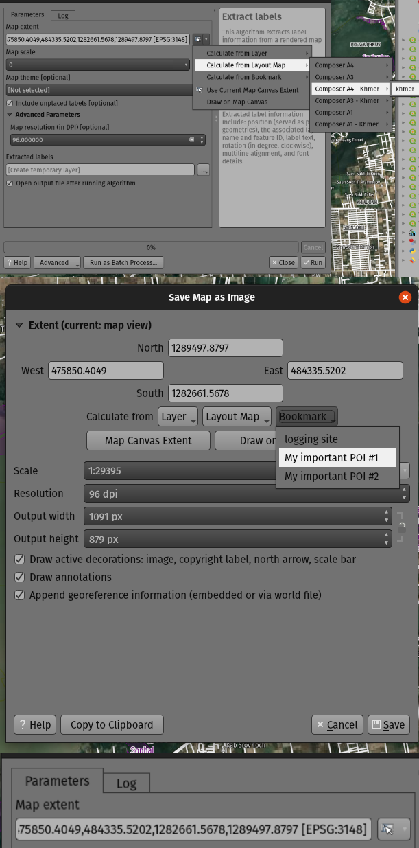
この機能は Mathieu Pellerin によって開発されました
機能: カスタム座標参照系の簡単な作成
座標参照系(CRS)を選択するときに、最初にこれらのカスタムCRSを投影法データベースに特別に追加する必要がなく、(projまたはWKT文字列から)カスタムCRS定義を直接入力できる新しいオプションを追加しました。
例えば特定の緯度と経度の位置に合わせて設計された投影法を使用した全体図地図など、単一の目的のためにカスタム投影法を定義したい場合、より使いやすくなります。
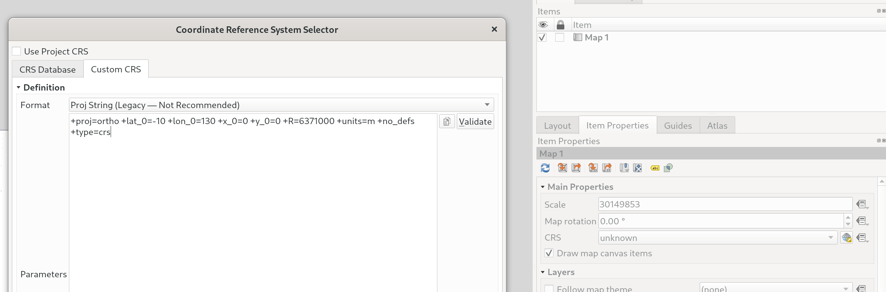
この機能は`Nyall Dawson <https://github.com/nyalldawson>`__ によって開発されました。
シンボロジ
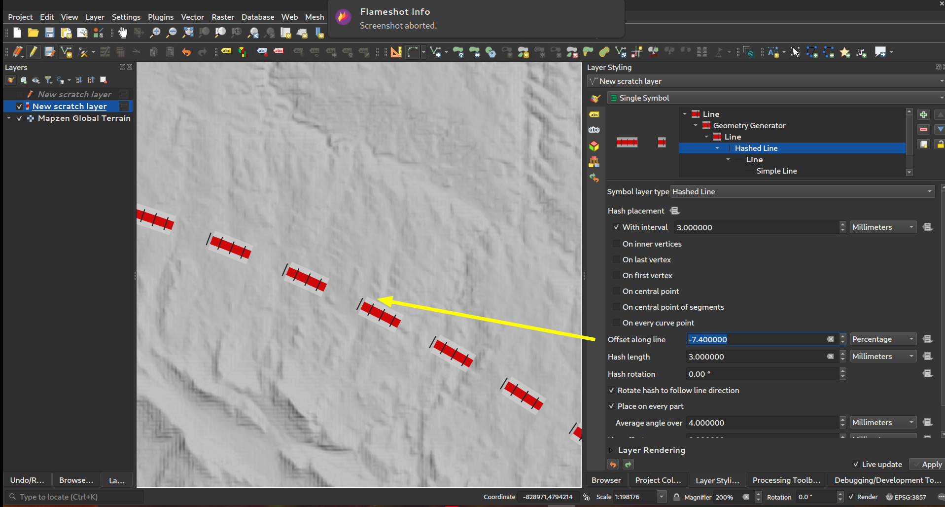
機能: マーカー/ハッシュ線: ラインの長さの「パーセント」によるラインに沿ったオフセット(そして負のオフセット!)
マーカーとハッシュ線シンボルレイヤタイプの両方に対して、線に沿ってオフセット をパーセンテージで指定できるようになりました。 (これらのオフセットは、全体の線の長さのパーセンテージとして扱われます)。
さらに、マーカーまたはハッシュラインシンボルレイヤーの オフセットに沿った 設定が 閉じた リングのサイズよりも長い場合、QGISはオフセットをリングの周りをループし続けるものとして扱うようになりました。たとえば、オフセットを150%に設定すると、オフセットは閉じたリングの長さの50%として扱われます。
最後に、私たちは閉じたリングに対してネガティブな「線に沿ったオフセット」を指定することも可能にしました。ネガティブなオフセットはリングに沿って逆方向に計算されます。
この機能は North Road, thanks to SLYR によって資金提供されました
この機能は`Nyall Dawson <https://github.com/nyalldawson>`__ によって開発されました。
機能: マルチパートジオメトリのあらゆる部分に最初/最後の頂点配置が適用されるかどうかを制御します
マーカーとハッシュラインのシンボルタイプのこの新しいシンボルオプションを使用すると、最初と最後の頂点配置オプションをマルチパートライン(またはポリゴン)のすべての部分に個別に適用するか、マルチパートジオメトリ全体中の最初と最後の頂点だけに適用するかを制御できます。
この機能は North Road, thanks to SLYR によって資金提供されました
この機能は`Nyall Dawson <https://github.com/nyalldawson>`__ によって開発されました。
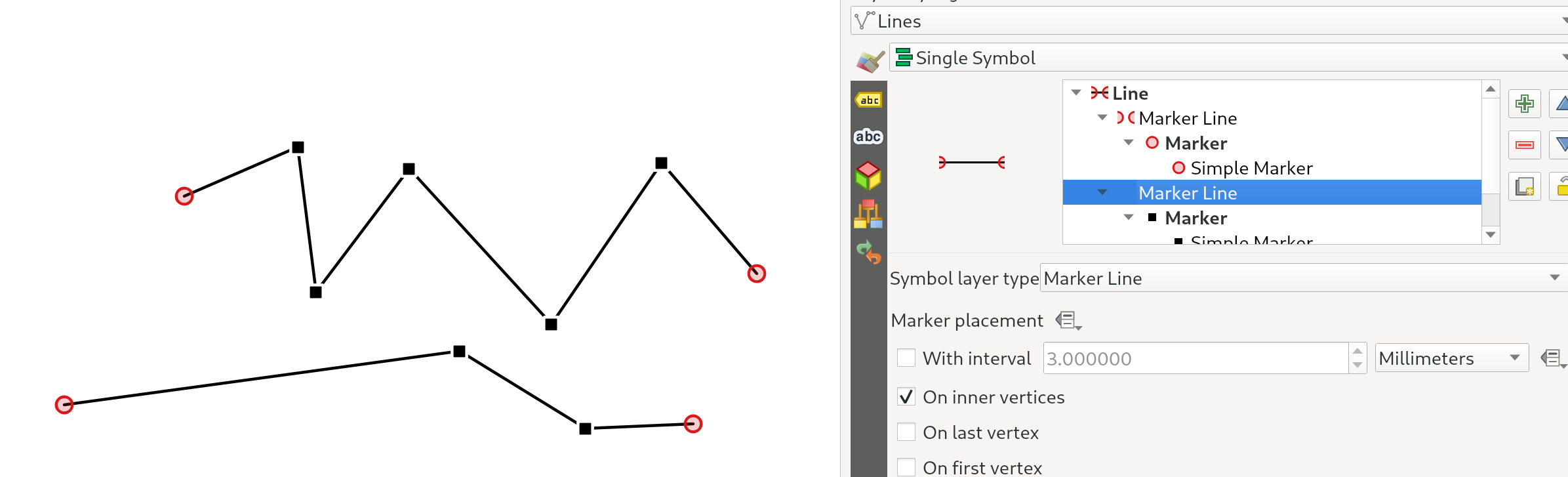
機能: マーカー/ハッシュ線 の「頂点上」 配置オプションが 「内部の点」に置き換えられました
新しい 内部の点 モードでは、シンボルはすべての 内部の 頂点に配置されます(つまり、最初または最後の頂点以外の全ての頂点)。
以前の「頂点」モードでは、最初と最後の頂点、および全ての内部の頂点にシンボルが配置されていたため、線の最初または最後の頂点に残りの頂点と 異なる マーカーを付けるスタイルを設定することは基本的に不可能でした。新しい 内部の点 オプションを使用すると、線の最初または最後の頂点と残りの頂点でマーカーが異なるスタイルを簡単に作成できます。
(この変更は、配置オプションにチェックボックスを使用する切り替えとうまく組み合わされています - 全ての頂点にマーカーを表示するには、最初、最後、および内部の頂点のオプションに確実にチェックを入れるだけです)。
この機能は North Road, thanks to SLYR によって資金提供されました
この機能は`Nyall Dawson <https://github.com/nyalldawson>`__ によって開発されました。
機能: グラデーションランプを補間する際に使用されるカラーモデルを制御します
グラデーションランプをレンダリングする場合、補間が赤/緑/青のチャネルを個別に使用して実行されると、グラデーションの色のいくつかの組み合わせにより、ランプが暗い灰色の中間調を通過します。別のアプローチは、代わりに、色相/彩度/明度または値チャネルを介して色を補間することです。このアプローチにより、これらの彩度の低いミッドトーンを回避でき、視覚的に心地よいグラデーションが得られます。
マルチストップカラーグラデーションでストップごとに色指定を設定できるようになり、ユーザーはどの補間手法を使用するかを制御できるようになりました。 HSL / HSVカラースペック補間の色相コンポーネントに対して補間が従うべき方向を制御するオプションもあります。これは、状況によっては、虹色相スペクトル全体での不要な補間を回避するのに役立ちます。
この ビデオ は、RGBの補間によるカラーランプの中間トーンの違いを示しており、その結果、色がくすんでしまいますが、HSL/HSVの補間では鮮やかさが保たれます。
この機能は North Road, thanks to SLYR によって資金提供されました
この機能は`Nyall Dawson <https://github.com/nyalldawson>`__ によって開発されました。
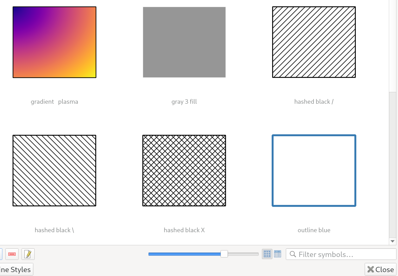
機能:スタイルマネージャダイアログ内のサムネイルのサイズ調整
スタイルマネージャダイアログでサムネイルの大きさを制御するため、新しいスライダーを追加しました。それは、サムネイルが小さすぎてシンボルが良く表示できないことがあるからです!
この機能は North Road, thanks to SLYR によって資金提供されました
この機能は`Nyall Dawson <https://github.com/nyalldawson>`__ によって開発されました。
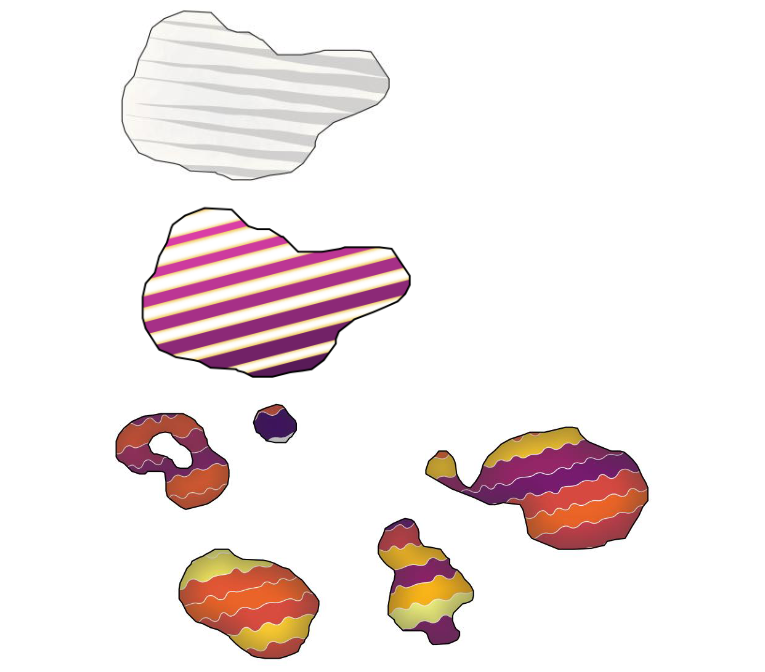
機能: 「線バースト」シンボル
新しい「線バースト」シンボルレイヤタイプを追加しました。これは、線の 幅 に沿ってグラデーションをレンダリングします(線の 長さ に沿ってグラデーションをレンダリングする補間された線レンダラとは異なります)。これは、Shapeburst塗りつぶしシンボルタイプと同様ですが、線用です!
この機能は North Road, thanks to SLYR! によって資金提供されました
この機能は`Nyall Dawson <https://github.com/nyalldawson>`__ によって開発されました。
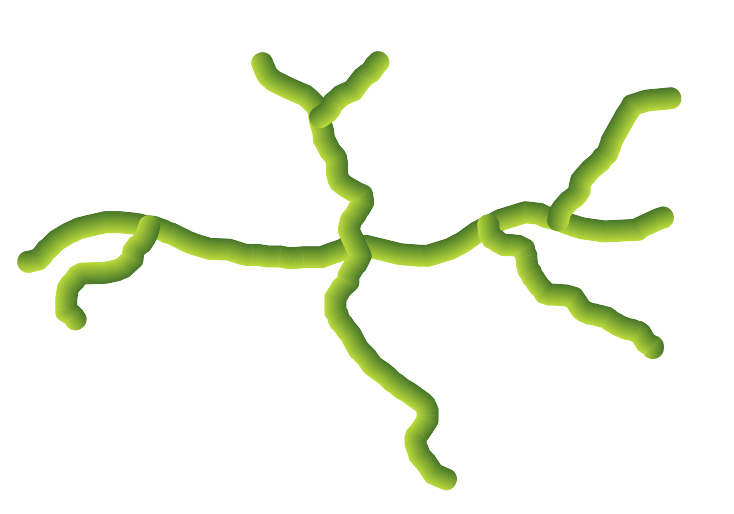
機能: 「ラスタ線」シンボル
このまったく新しいラインシンボルタイプをお届けできることを大変うれしく思います。これにより、ライン図形の形状に従ってラスタ画像をレンダリングできます。このシンボルタイプは、QGISシンボルの可能性のまったく新しい領域を開き、手描きまたはペイントされたスタイルで地図を作成するときに特に役立ちます。
制御するオプションが利用できます:
写真のパス(データ定義パスを含む)
線幅
透明度
線の継ぎ目と両端のスタイル
この機能は North Road, thanks to SLYR によって資金提供されました
この機能は`Nyall Dawson <https://github.com/nyalldawson>`__ によって開発されました。
機能: ラインパターン塗りつぶしのクリッピング動作の選択
ラインパターン塗りつぶしシンボル内の線がポリゴン形状に切り抜かれる方法を制御できるようになりました。利用可能なオプションには次のものがあります:
レンダリング中のみクリップ :地物の バウンディングボックス 全体をカバーする線が作成され、描画中にクリップされます。線の端(開始と終了)は表示されません(これは古いQGISリリースと同じ動作です)。
レンダリング前に線をクリッピング: ラインはレンダリング前にポリゴンの 正確な形状 に切り抜かれます。ラインの端部(キャップスタイル、開始/終了マーカーラインシンボルなどを含む)は見えるようになり、(ラインシンボルの設定によっては)ポリゴンの外側に拡張されることがあります。
クリッピングしない: クリッピングは一切行われず、ラインは地物のバウンディングボックス全体をカバーします
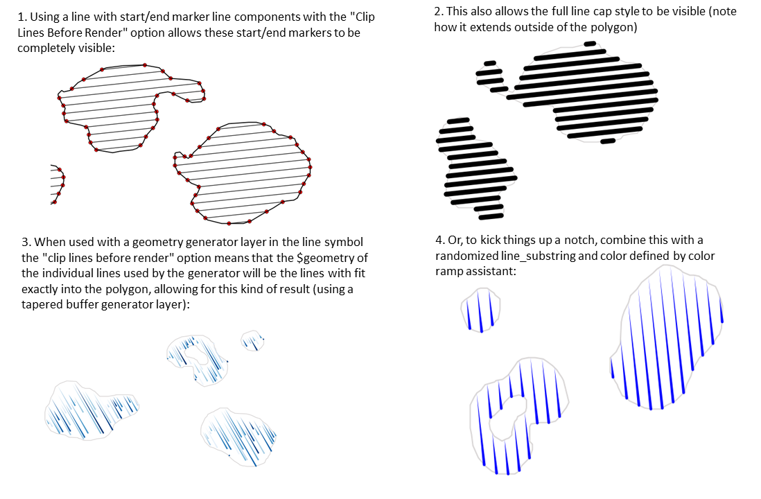
この機能は North Road, thanks to SLYR によって資金提供されました
この機能は`Nyall Dawson <https://github.com/nyalldawson>`__ によって開発されました。
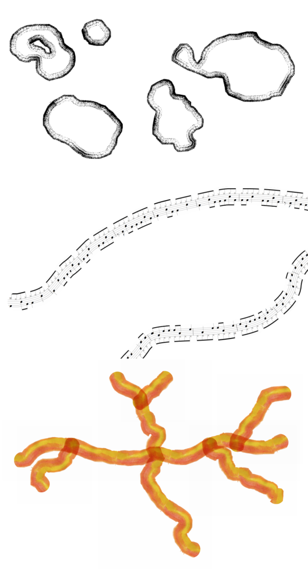
機能: ラインパターン塗りつぶしのレンダリングが改善
ベクタ形式(PDFやSVGなど)にエクスポートする場合、またはラインのサブシンボルに動的(データ定義)プロパティがある場合、塗りつぶしをレンダリングするためにラインごとのアプローチに自動的に切り替えるようになりました。 (以前は、タイルパターンのアプローチが常に使用されていたため、パターンに望ましくないアーティファクトや目に見える継ぎ目が生じることがよくありました)。
この変更の多くの利点には、次のものがあります:
PDF/SVG出力ファイルの大きさがより小さくなる -- ラインパターン塗りつぶしは出力時にラスタ画像として保存されないため、全体のファイルサイズは通常ずっと小さくなります
PDF/SVGでエクスポートされたファイルは、パターン内の個々の線を修正することができるため、ポストプロダクション用の外部アプリケーション(Inkscapeやアドビイラストレーターなど)で修正するのがより容易です。
塗りつぶしがDPIに依存せず、どんなに拡大してもピクセルとして完全に見えるため、より高品質なPDF/SVG出力が可能です
特定の角度、距離、または特定のラインシンボルスタイルでは、見えるアーティファクトはありません
さらに興奮することに、それは新しいシンボルスタイルの幅広い選択肢を開くのです。例えば:
個々の線で色/幅/破線などが変わるラインパターン
中点/その他の所にマーカーラインシンボルを使用するラインパターン
線ごとのジオメトリジェネレータ効果、例えば、波線パターン、手書きラインスタイルなど
この機能は North Road, thanks to SLYR によって資金提供されました
この機能は`Nyall Dawson <https://github.com/nyalldawson>`__ によって開発されました。
機能: ポイントパターン塗りつぶしのための回転角度
Now you can specify an optional rotation angle for point pattern fills, which causes the entire point pattern to be angled. This can be extremely useful when overlaying multiple point pattern fills!
この機能は North Road, thanks to SLYR によって資金提供されました
この機能は`Nyall Dawson <https://github.com/nyalldawson>`__ によって開発されました。
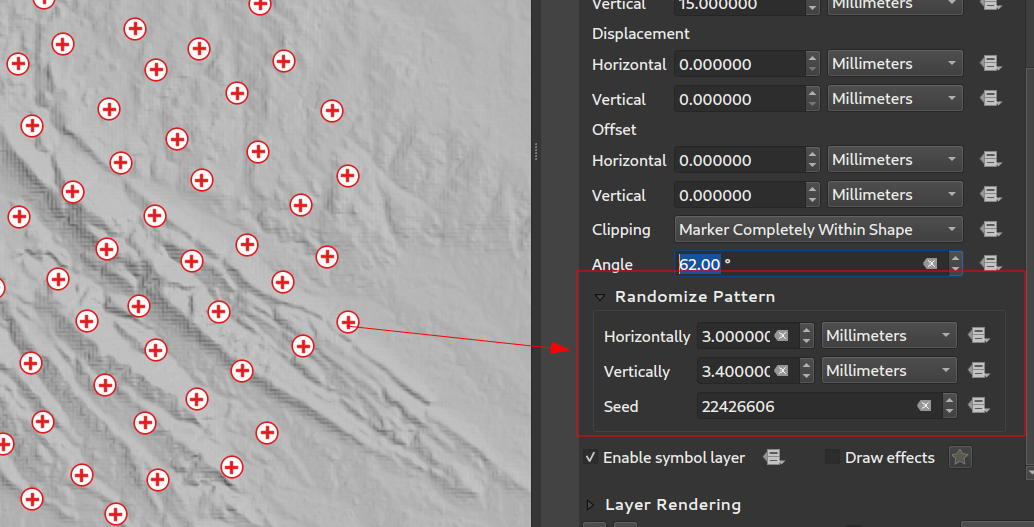
機能: ポイントパターン塗りつぶしのランダム化ポイントオフセット
この(オプションの)設定により、ポイントパターン塗りつぶしの各ポイントを、xまたはy方向に指定された最大距離までランダムにシフトできます。最大オフセットは、ミリメートル、ポイント、地図単位、または「パーセンテージ」単位で指定できます(パーセンテージはパターンの幅または高さを基準にしています)。
You can set an optional random number seed to avoid the symbol patterns "jumping" around between map refreshes. Data defined overrides are also supported.
この新しい設定と既存の ランダムマーカー塗りつぶし シンボルタイプの主な違いは、ポイントパターンのランダムオフセットにより、マーカーの準「通常の」配置が可能になることです。これは、パターン内のポイントが効果的にグリッドに拘束されるためです。 、これにより、空の領域や重複するマーカーのないセミランダムな塗りつぶしを作成できます。 (常に完全にランダムにポイントを配置するランダムマーカーフィルとは対照的に...ポイントの視覚的なクラスターまたは不要な空の領域が生じる場合があります)。
この機能は North Road, thanks to SLYR によって資金提供されました
この機能は`Nyall Dawson <https://github.com/nyalldawson>`__ によって開発されました。
機能:ラインパターンとポイントパターン塗りつぶしシンボルレイヤの座標参照モードの設定
ラインパターンとポイントパターン塗りつぶしシンボルレイヤには、パターンのアンカリングを微調整するための新しい座標参照モード設定があります。実際的には、これにより、隣接する地物や重なり合う地物に対してパターンをきれいに整列させることができます。

この機能は Mathieu Pellerin によって開発されました
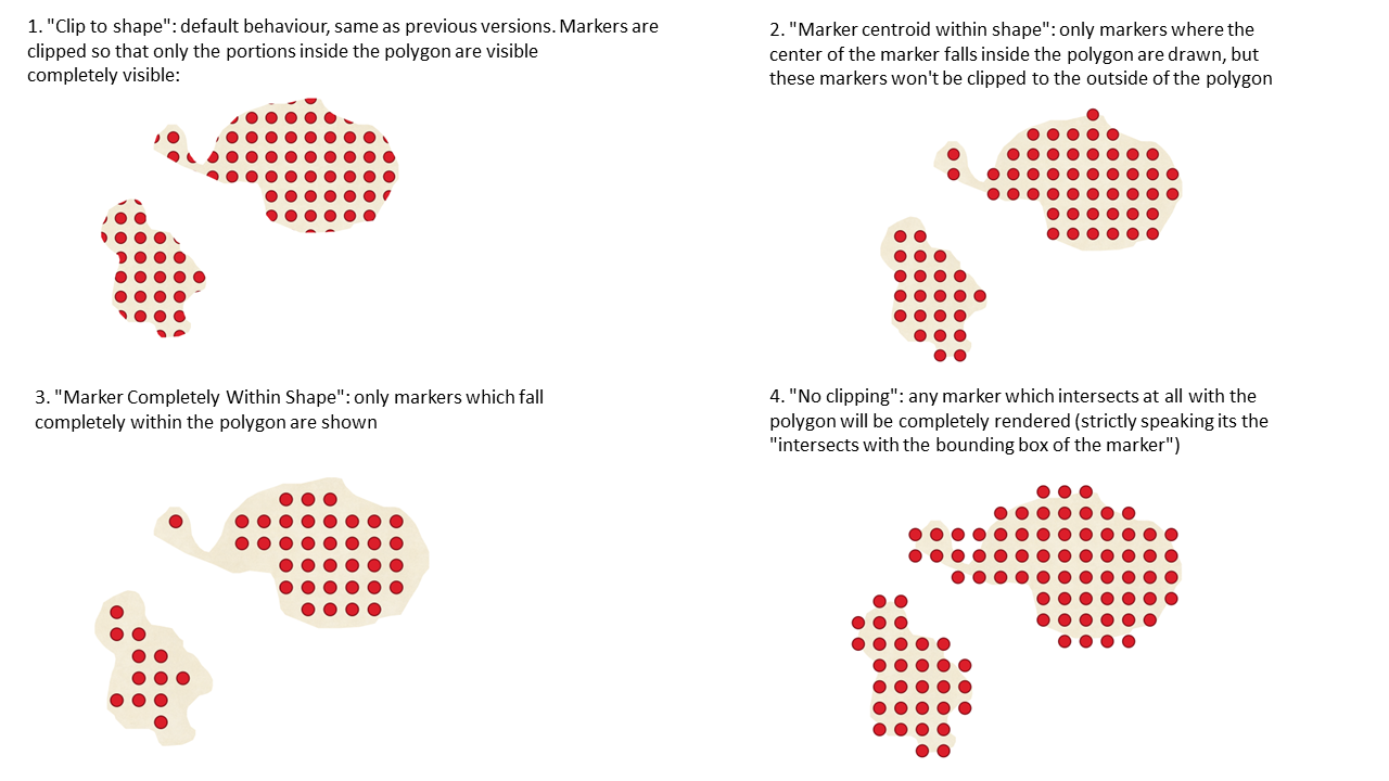
機能: ポイントパターン塗りつぶしのためのマーカーのクリッピングを制御する
This new option gives you control over how markers are clipped in a point pattern fill. The available options include:
Clip to shape: markers will be clipped by the boundary of the shape, so "cut off" markers may be visible (same behaviour as previous QGIS versions)
Marker centroid within shape: markers will be drawn only if their centroid falls within the shape, and markers will not be clipped to the shape boundary
Marker Completely Within Shape: markers will only be drawn if they fit completely within the shape
No clipping: whole marker symbols will be drawn if any part of the marker falls within the shape
この機能は North Road, thanks to SLYR によって資金提供されました
この機能は`Nyall Dawson <https://github.com/nyalldawson>`__ によって開発されました。
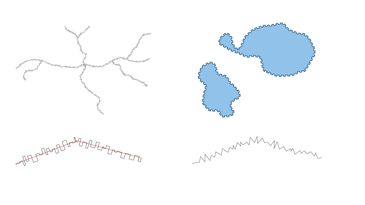
機能: 三角波/正方形波/曲線波を作成するための式関数
We've added some new expression functions which produce "wavy lines" along geometry boundaries. Multiple wave shapes are available, including:
Wave (正弦に似た)
Triangular
Square
In addition, expressions functions have also been added for creating waves in a regular fashion or with randomization.
When used with geometry generators, these expressions can be used for some very advanced cartographic effects!
この機能は North Road, thanks to SLYR によって資金提供されました
この機能は`Nyall Dawson <https://github.com/nyalldawson>`__ によって開発されました。
ラベリング
Feature: "Percentage" units for text buffer size, shadow offset and blur radius
テキストバッファ、シャドウオフセット、シャドウブラー半径のサイズをフォントサイズのパーセンテージとして設定できるようになりました。これは、テキストサイズが変更されたときに個別に調整する必要がある固定のバッファ/シャドウサイズではなく、テキストサイズの変更に応じてコンポーネントが適切にスケーリングされるテキスト形式を作成できるため、望ましい方法です。
この機能は North Road, thanks to SLYR によって資金提供されました
この機能は`Nyall Dawson <https://github.com/nyalldawson>`__ によって開発されました。
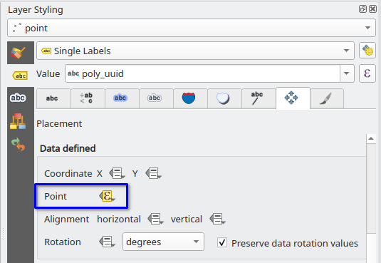
Feature: Data defined label positions by point geometries
これで、データで定義されたラベルの配置を、ポイントジオメトリフィールドまたは式にバインドするように設定できます。 (以前のQGISバージョンでは、2つの別々の数値のxフィールドとyフィールドを介してデータ定義の配置のみを設定できました)。
この変更により、 ラベルの移動 ツールを使用して、ポイントジオメトリフィールドにバインドされているラベルの位置を変更し、新しいラベルの位置をその属性にポイントジオメトリとして保存することもできます。
この機能はスイスQGISユーザーグループによって資金提供されました
この機能は Damiano Lombardi によって開発されました
機能:ラベルとテキスト形式のための伸縮テキスト
この改善により、テキストをパーセンテージ係数で水平方向に拡大または縮小できます。フォントの幅を微調整して、ラベルに少し余分なテキストを収めるのに便利なことがよくあります(控えめに使用すること、つまり…フォントの伸縮を悪用して恐ろしい結果を招く可能性があります)。
Note: This improvement requires Qt 6.3+ or KDE's 5.15 fork. (On other builds the stretch options are hidden and can't be set)
この機能は North Road, thanks to SLYR によって資金提供されました
この機能は`Nyall Dawson <https://github.com/nyalldawson>`__ によって開発されました。
レンダリング
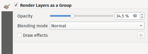
Feature: Rendering layers as groups
This is another exciting cartographic enhancement which opens up a whole new arena of symbology and map visualisation in QGIS!
この改善の前は、QGISはプロジェクトを構造化する手段としてレイヤツリー内のレイヤのグループ化をサポートしていましたが、これらのグループはコンポーネントレイヤのレンダリング方法に影響を与えませんでした。 QGIS 3.24では、これらのレイヤーグループを「 グループとしてレンダリング 」できる新しいオプションを導入しました。これにより、地図のレンダリング中にすべてのコンポーネントレイヤが単一のフラット化されたオブジェクトとしてレンダリングされます。
このオプションは、グループレイヤーが選択されている場合は常に、レイヤースタイリングドック内で使用できます。このパネルでは、グループ全体の不透明度、ブレンドモード、レイヤー効果のオプションを使用して、グループ全体の外観を制御することもできます。
さらに、新しい グループとしてレンダリング オプションがアクティブになっているグループにレイヤーが含まれている場合、レンダリング中に「クリッピング」スタイルの操作を実行する新しいブレンドモードが利用可能になります。これらを使用すると、1つのレイヤーのコンテンツのレンダリングを、2番目の「マスク」レイヤーのコンテンツでクリッピングするなど、非常に強力な結果を得ることができます。
この機能は Andrew Fletcher によって資金提供されました。
この機能は`Nyall Dawson <https://github.com/nyalldawson>`__ によって開発されました。
Feature: Support for "Line pattern" when converting Mapbox GL vector tile layer styles
Making use of the brand new raster line symbol layer, QGIS 3.24 now properly renders Mapbox GL line pattern styling for newly-added vector tile layers.
この機能は Mathieu Pellerin によって開発されました
Feature: Support background styles for Mapbox GL-styled vector tile layers
We now correctly render any predefined background styling present in Mapbox GL-styled vector tile layers. This dramatically improves the appearance of vector tile layers with dark styles!
この機能は Mathieu Pellerin によって開発されました
三次元機能
Feature: Respect Z ordering when rendering point clouds in 2D
二次元地図ビューで点群をZ順序に従ってレンダリングするオプションを追加しました。新しい 下から上へ の順序付けオプションを有効にすると、Z値が大きい点が低い点を覆って、真の正射写真のように見えます。シーンが下から見たように表示される逆ソート( 上から下へ )のオプションもあります。
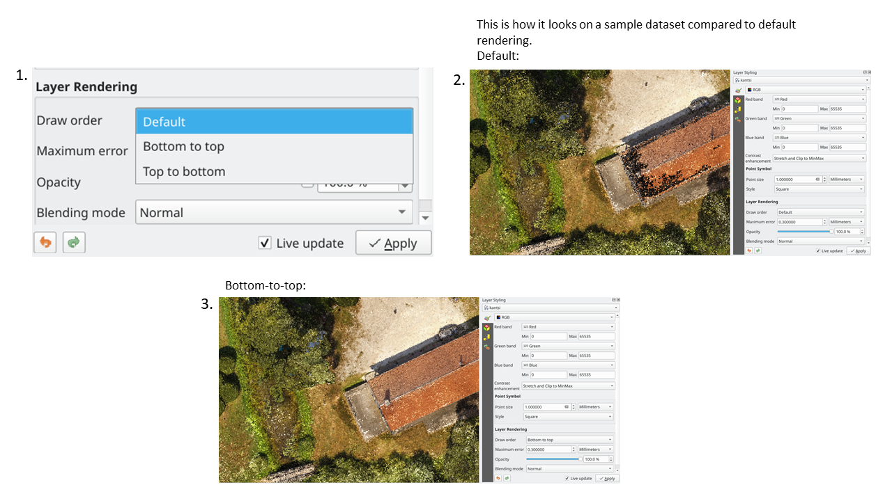
この機能は クラウドファンディング: Enhancing elevation data and point clouds in QGIS によって資金提供されました
この機能は Stefanos Natsis (Lutra Consulting) によって開発されました
Feature: Dock/Undock 3D views
三次元地図にドックウィジェットを使用すると不便になる可能性があることは認識しております。多くの場合、サイズを調整すると再ドッキングする傾向があるため、サイズ変更や移動にイライラします。 QGIS 3.24では、三次元地図をドッキング可能なウィジェットからトップレベルウィンドウに(そしてドックウィジェットに戻す)切り替える機能が追加され、これらの地図ビューを標準のアプリケーションウィンドウと同じように管理、サイズ変更、移動できるようになりました。
この機能は クラウドファンディング: Enhancing elevation data and point clouds in QGIS によって資金提供されました
この機能は Nedjima Belgacem (Lutra Consulting) によって開発されました
Feature: 3D map view manager
Previously, if you closed a 3D map view and then saved your project, the 3D map view and all its settings would be lost when you reopen that project. So in QGIS 3.24 we've added a "3D map view manager" that takes care of listing, removing, renaming and duplicating 3D map views in your projects!
We've also added a new "3D Map Views" menu, which contains all your created 3D map views for easy access!
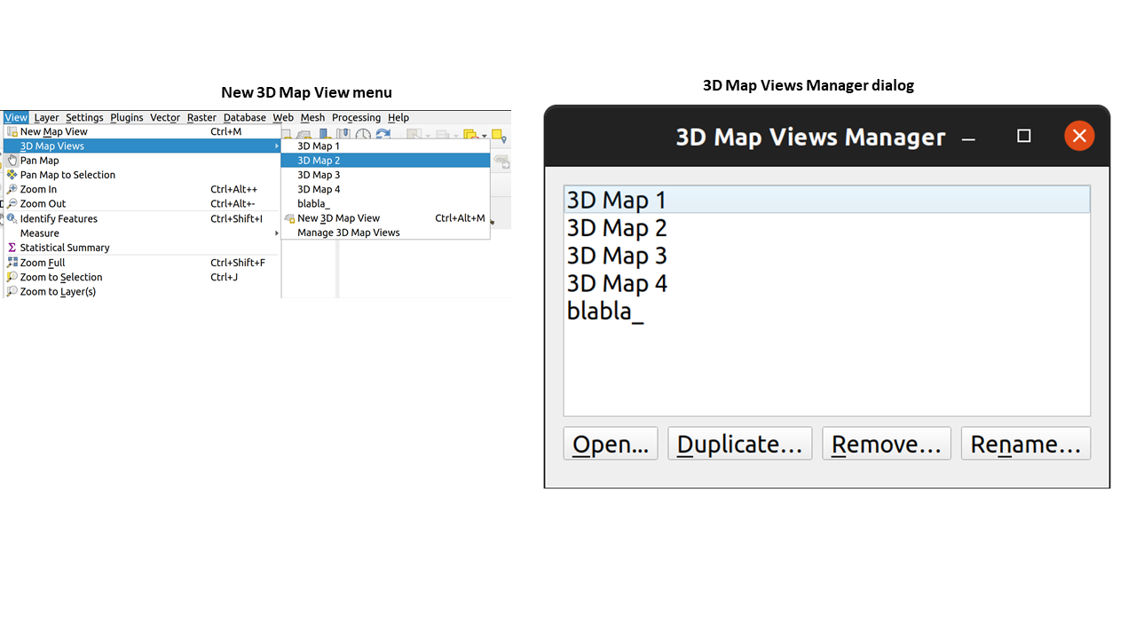
この機能は クラウドファンディング: Enhancing elevation data and point clouds in QGIS によって資金提供されました
この機能は Nedjima Belgacem (Lutra Consulting) によって開発されました
印刷レイアウト
Feature: Full text rendering capabilities for layout text labels
以前のQGISリリースでは、HTMLやCSSを使用して、地図レイアウトのテキストにドロップシャドウなどの効果を追加するなど、ハッキーなトリックに戻す必要がありました。もうハックしないでください! 3.24では、レイアウト上のテキストのラベル付けテキストオプションからおなじみのプロパティを使用できるようになりました。これは、レイアウト内のテキストアイテムに、シャドウ、テキストバッファ、背景、文字と単語の間隔などをすべて追加できることを意味します。
この機能は North Road, thanks to SLYR によって資金提供されました
この機能は`Nyall Dawson <https://github.com/nyalldawson>`__ によって開発されました。
計算式
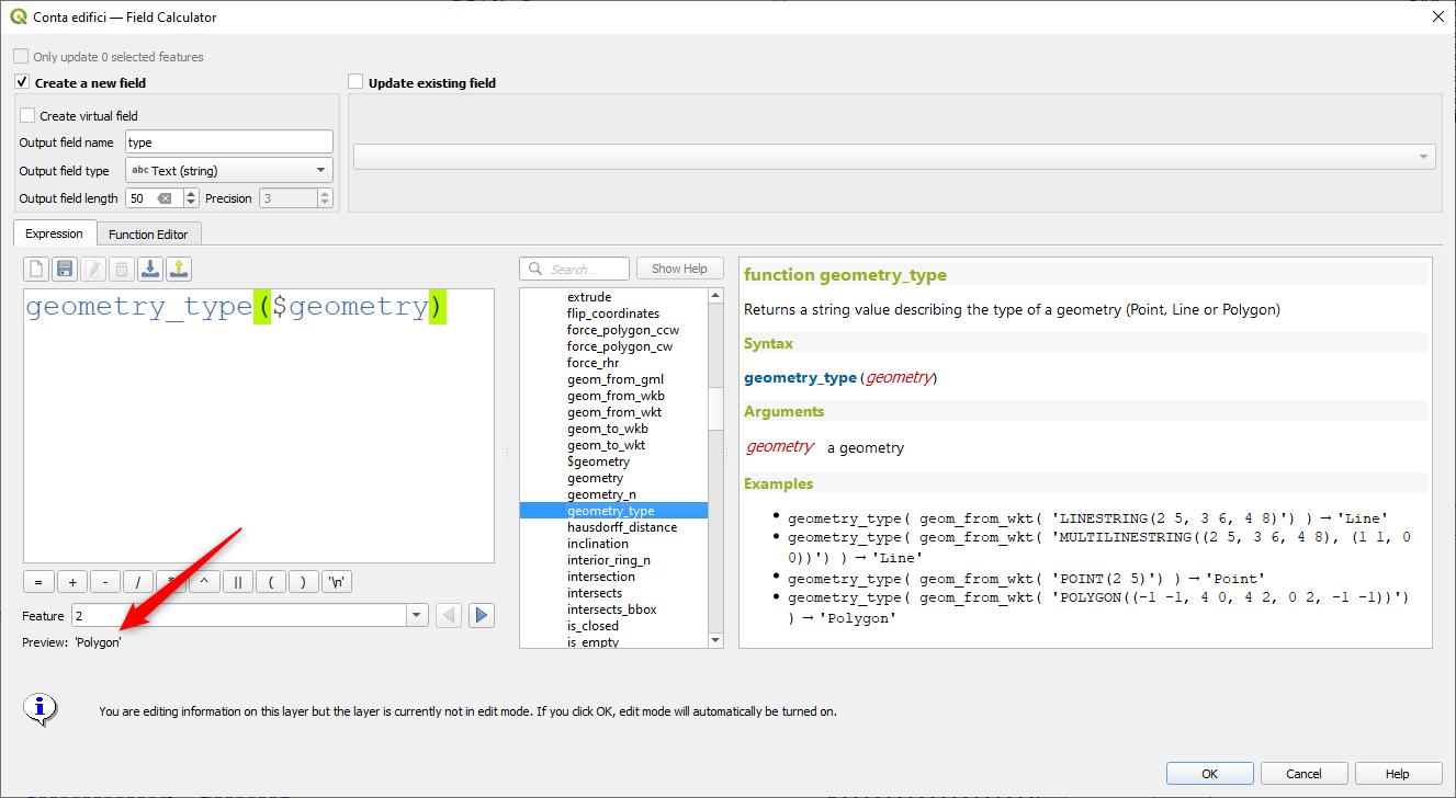
機能: geometry_type 関数
The new geometry_type function returns the high-level type of a geometry (i.e. 'Point', 'Line' or 'Polygon').
この機能は North Road, thanks to SLYR によって資金提供されました
この機能は`Nyall Dawson <https://github.com/nyalldawson>`__ によって開発されました。
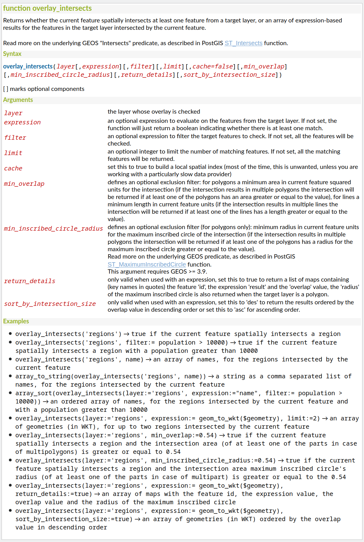
Feature: Overlay intersects sort by intersection size
We have added further enhancements to the overlay_intersects function. The change adds two new optional arguments to the existing function:
return_details: only valid when used with an expression, set this to true to return a list of maps containing (key names in quotes) the feature 'id', the expression 'result' and the 'overlap' value, the 'radius' of the maximum inscribed circle is also returned when the target layer is a polygon.
sort_by_intersection_size: only valid when used with an expression, set this to true to return the results ordered by the overlap value in descending order.
この機能は Kanton Solothurn, Amt für Geoinformation によって資金提供されました
この機能は Alessandro Pasotti によって開発されました
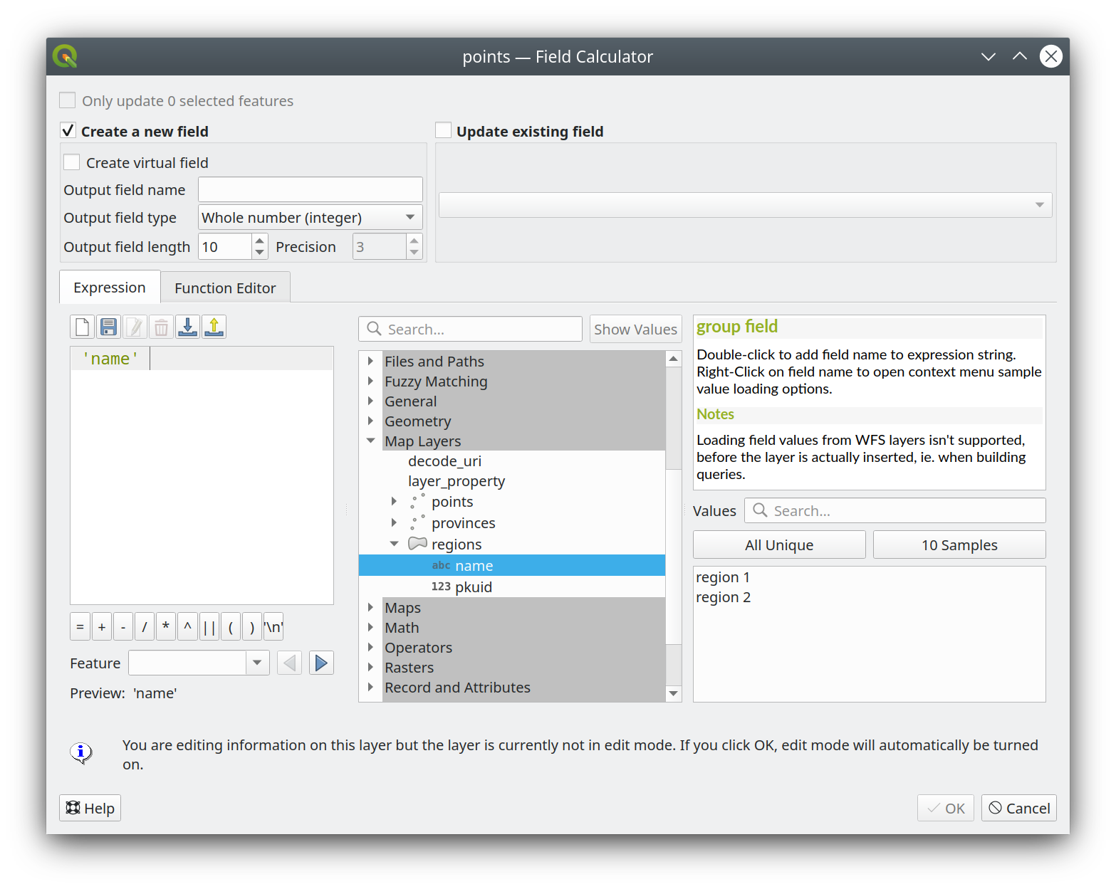
Feature: Show all layer field names when building expressions
As a handy time-saver, we now make a list of all field names from all layers in your project available directly in the expression builder. If you double-click any of these field names, they'll be added to your expression as string values ('field_name').
この機能は ARPA Piemonte によって資金提供されました
この機能は Alessandro Pasotti によって開発されました
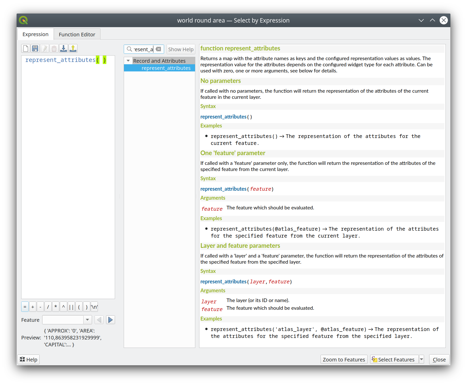
Feature: represent_attributes function
This new function returns a map with all attribute (field) names as the keys and the configured representation values as values. The representation value for the attributes depends on the configured widget type for each attribute.
The function can be used with zero, one, or more arguments:
If called with no parameters, the function will return the representation of the attributes of the current feature in the current layer.
地物だけを引数として関数を呼んだ場合、関数は現在のレイヤの指定された地物の代表値を返します。
レイヤと地物を引数として関数を呼んだ場合、関数は指定されたレイヤの指定された地物の属性の代表値を返します。
この機能は Kanton Solothurn によって資金提供されました
この機能は Alessandro Pasotti によって開発されました
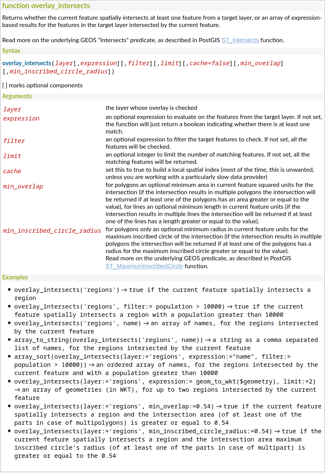
Feature: Optional minimum overlap area and circle radius for overlay_intersection
We have added two optional arguments to the overlay_intersection() expression function:
min_overlap: for polygons an optional minimum area in current feature squared units for the intersection (if the intersection results in multiple polygons the intersection will be returned if at least one of the polygons has an area greater or equal to the value), for lines an optional minimum length in current feature units (if the intersection results in multiple lines the intersection will be returned if at least one of the lines has a length greater or equal to the value)min_inscribed_circle_radius: for polygons only an optional minimum radius in current feature units for the maximum inscribed circle of the intersection (if the intersection results in multiple polygons the intersection will be returned if at least one of the polygons has a radius for the maximum inscribed circle greater or equal to the value). Read more on the underlying GEOS predicate, as described in PostGIS ST_MaximumInscribedCircle function.
この機能は Kanton Solothurn によって資金提供されました
この機能は Alessandro Pasotti によって開発されました
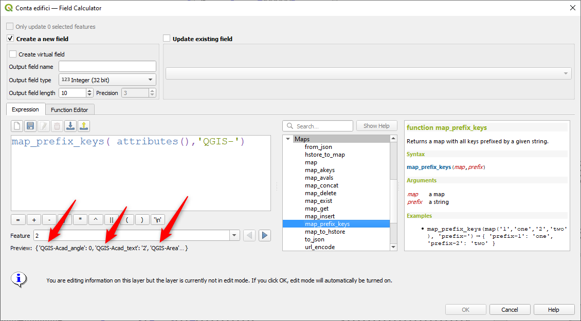
Feature: map_prefix_keys function
In QGIS 3.24 we've added a new map_prefix_keys function that takes a map and a prefix, the function returns a map with all keys prefixed by the prefix.
Example:
map_prefix_keys(map('1','one','2','two'), 'prefix-')
returns:
{ 'prefix-1': 'one', 'prefix-2': 'two' }
この機能は Kanton Solothurn によって資金提供されました
この機能は Alessandro Pasotti によって開発されました
Feature: densify_by_count and densify_by_distance functions
This functionality, which was previously only available through the Processing toolbox, is now available for use in expressions!
この機能は North Road, thanks to SLYR によって資金提供されました
この機能は`Nyall Dawson <https://github.com/nyalldawson>`__ によって開発されました。
Feature: Rotate parts of multi-part geometries independently with "rotate" expression function
The new "per_part" option for the "rotate" expression function allows you to rotate each part of a multi-part geometry around the center of each part (instead of the center of the geometry as a whole). This enhancement is designed to help out symbology when the rotate function is used as a cartographic tool as part of a geometry generator symbol layer.
この機能は North Road, thanks to SLYR によって資金提供されました
この機能は`Nyall Dawson <https://github.com/nyalldawson>`__ によって開発されました。
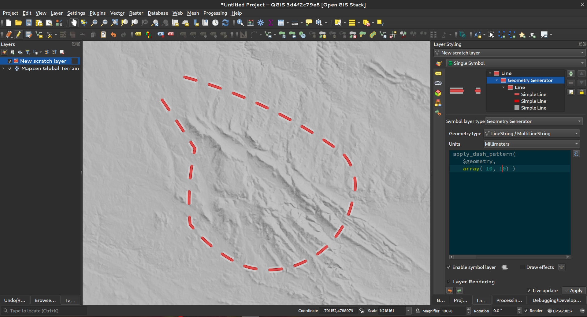
Feature: apply_dash_pattern function
This exciting new expression function applies a dash pattern to a geometry, returning a MultiLineString geometry which is the input geometry stroked along each line (or ring) using a dashed line pattern.
Rules can be set to control how the dash pattern is adjusted at line endings. If you specify a start rule or end rule, then the "adjustment" option defines whether both dash and gaps, or only dash or gap sizes are adjusted to apply these rules.
You can also set an optional pattern offset to specify how far along the pattern the result should start at.
この機能は North Road, thanks to SLYR によって資金提供されました
この機能は`Nyall Dawson <https://github.com/nyalldawson>`__ によって開発されました。
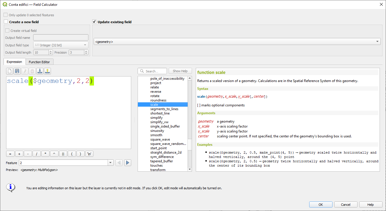
Feature: scale function
This new expression function allows you to scale (resize) a geometry. Just like the 'rotate' function, the function accepts an optional point position to apply the scaling from. If no anchor point is not specified then scaling is done from the center of the geometry's bounding box.
この機能は North Road, thanks to SLYR によって資金提供されました
この機能は`Nyall Dawson <https://github.com/nyalldawson>`__ によって開発されました。
Feature: Filter by multiple attributes for get_feature function
We extended the get_feature function to allow multi-attribute filtering, by adding an option to pass an array of filter values to the input.
この機能は Alex によって開発されました
データ管理
Feature: Multiedit support for relation editor
We've added a new multi edit mode for the relation editor, which allows the rapid addition of child features to multiple parent features. This improves efficiency for data management operations, such as the ability to select multiple trees and adding a maintenance item to all of them in one click.

この機能は QGIS Model Baker によって資金提供されました
この機能は Damiano Lombardi, OPENGIS.ch によって開発されました
メタデータとメタサーチ
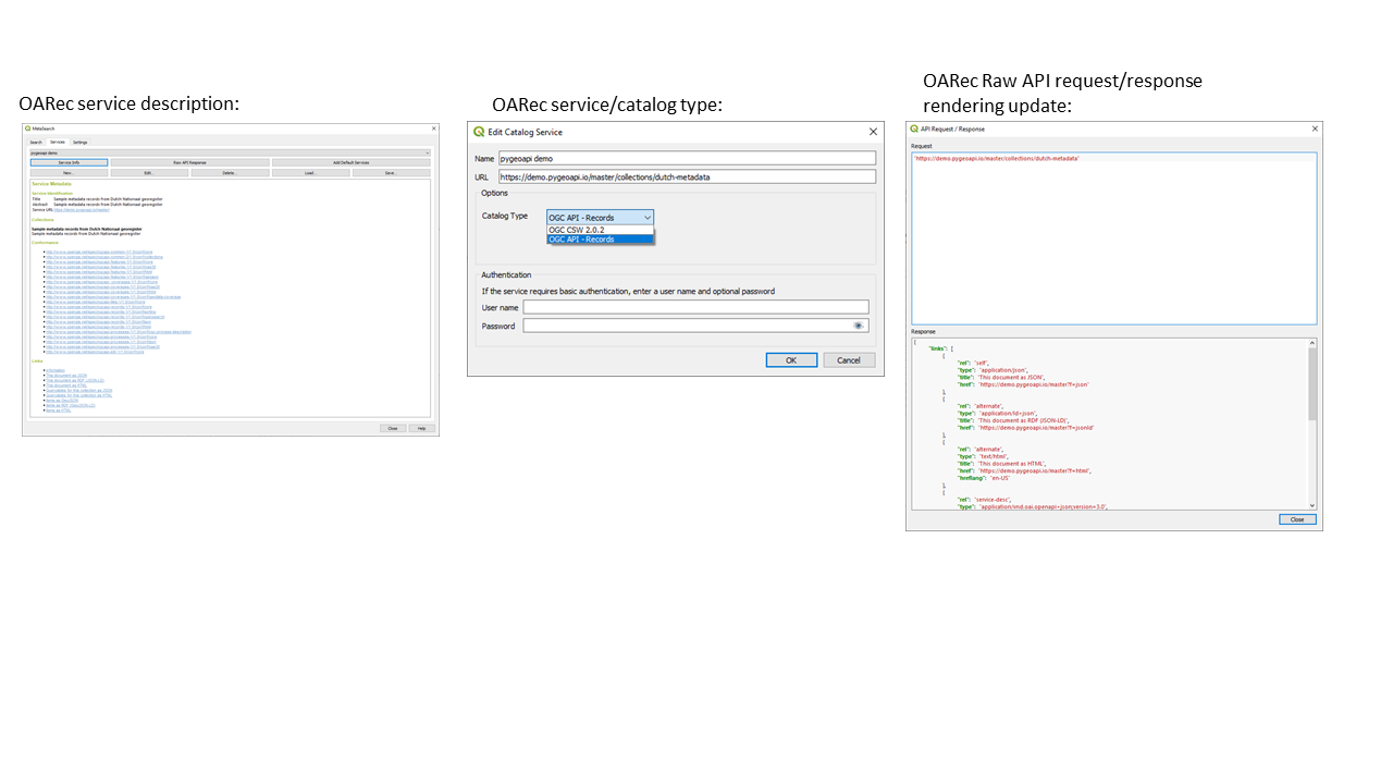
Feature: Support for OGC API - Records in MetaSearch
We updated the MetaSearch tool to provide support for the OGC API - Records (OARec) standard. As part of the OGC API evolution, OGC API - Records is the successor to OGC:CSW (like OGC API - Features is to WFS, etc.).
The OGC API - Records standard is currently in development and the current timeline for a public RFC by OGC is Q1 2022. This we ask you to take note of the draft status of the specification so you are aware that the specification may change a bit more over the next few months. We still need to flesh out how actionable links are handled over the next few months (which should be a significant improvement compared to the CSW publish/find/bind workflow).
Adding this feature to QGIS is a huge win for easier search and will help both users and providers for the long term.
この機能は Tom Kralidis によって開発されました
フォームとウィジェット
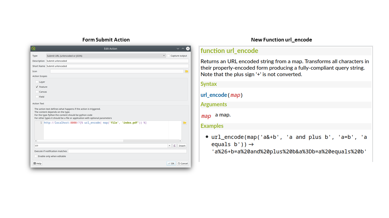
Feature: Form submit actions with HTTP POST
In QGIS 3.24 we added two new HTTP POST actions, similar to the existing Open action which uses an HTTP GET request.
The two actions differ in the way the form data are encoded:
application/x-www-form-urlencoded
multipart/form-data
In both cases, data are passed to the action in a URL encoded URL.
A new function url_encode(<map>) is provided to convert a dictionary (a map) to the encoded format.
The response from the submitted URL is opened by delegating to the operating system QDesktopServices::openUrl() after the payload has been stored in a temporary file.
この機能は Kanton Solothurn によって資金提供されました
この機能は Alessandro Pasotti によって開発されました
Feature: New button to open attribute table on filtered features
We've added a new button to the attribute form (when in search mode) which enables you to open an attribute table filtered to only show the matching features.
この機能は ARPA Piemonte によって資金提供されました
この機能は Alessandro Pasotti によって開発されました
分析ツール
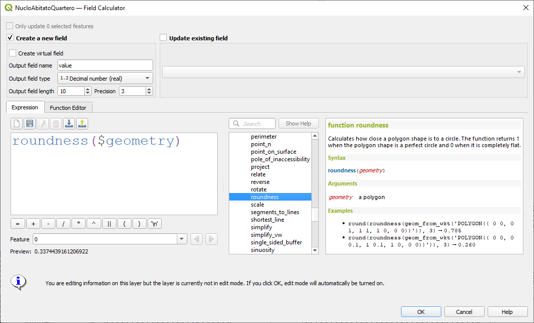
Feature: Add roundness method to curve polygon
We added a "roundness" method to QgsCurvePolygon, allowing the calculation of the "roundness" of an area feature based on the formula Roundness = (4 * pi * Area) / Perimeter^2.
This includes the addition of a new expression and a processing tool for calculating roundness. The processing tool creates a new layer with the roundness of each feature in a new field.
この機能は Antoine Facchini によって開発されました
プロセシング
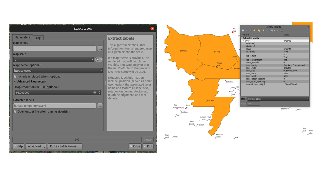
Feature: Extract labels algorithm
For 3.24 we added a new tool to QGIS' processing toolbox: "Extract labels". As its name hints at, this algorithm extracts label information from a rendered map at a specific extent and scale.
Extracted label information include its position (as point geometries), the associated layer name and feature ID, as well as label appearance properties such as rotation, text, alignment, font family, size, weight, etc.
このアルゴリズムは、出力レイヤーのデフォルトのシンボルなしのラベル付きスタイルも生成します。これにより、保存されたレイヤーをプロジェクトにドラッグアンドドロップして、エクスポートされたとおりにラベルを描画できます。
If a map theme is specified when extracting labels, the exported labels will match the visibility and symbology of that theme. If left blank, the project's current visible layers will be used.
この機能は TEKSI によって資金提供されました
この機能は、Mathieu Pellerin によって開発されました
Feature: Optional output extent parameter for the GDAL Raster Calculator algorithm
GDAL 3.3以降に対して実行する場合、QGIS処理ツールボックスのGDALラスター計算アルゴリズムでオプションの「出力範囲」パラメーターを指定できるようになりました。これは、大規模なデータセットを操作する場合に非常に役立ちます。多くの場合、計算機アルゴリズムを実行する前に、中間のクリップされたラスターを作成する必要がありません。
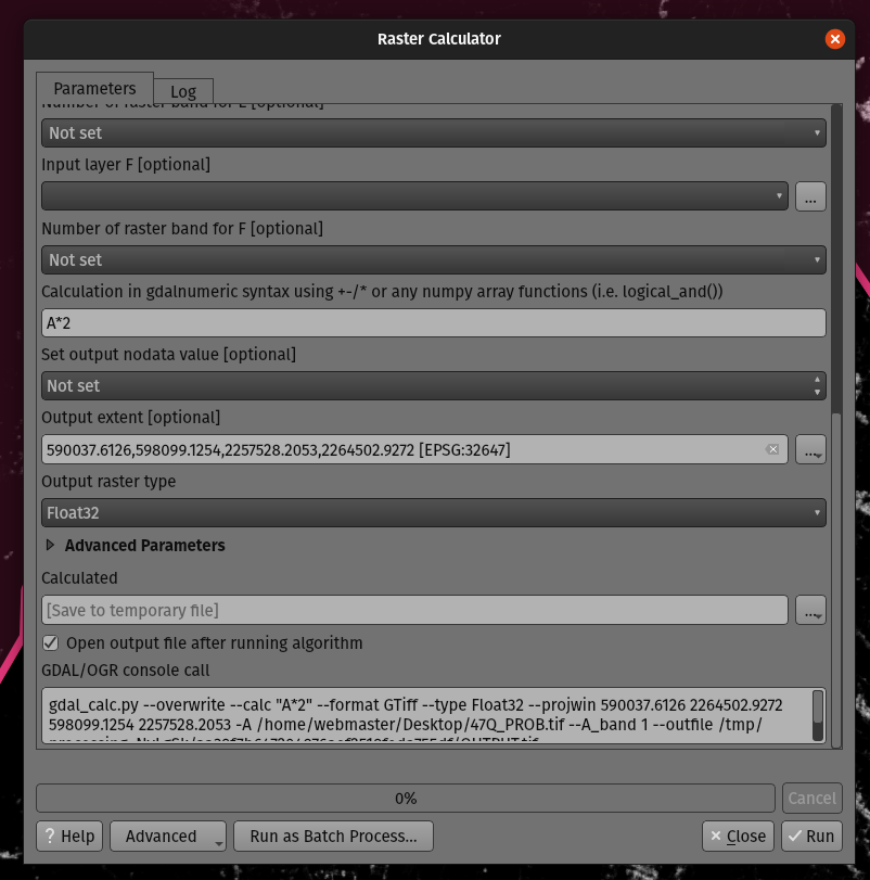
この機能は Mathieu Pellerin によって開発されました
Feature: Optional extent parameter for the GDAL clip raster by mask algorithm
We added an optional extent parameter to the GDAL "clip raster by mask" algorithm, which can come in handy when working with large raster datasets.
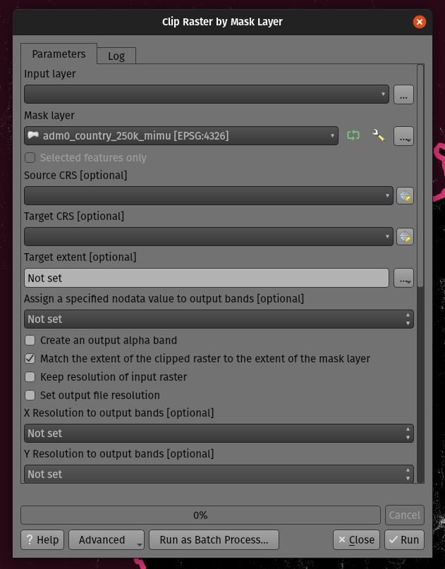
この機能は Mathieu Pellerin によって開発されました
Feature: Processing history rework
QGIS 3.24 includes a partial implementation of the framework described in QEP 130, and ports the Processing history log over to this framework.
これは、実行されたツールに関する無制限の追加情報(すべての入力パラメーター、出力結果、および全文ログも含む)を保存できるため、処理履歴を保存するためのはるかに柔軟なアプローチです。履歴ログは、以前に使用されていたテキストファイルではなく、sqliteデータベースに保存されるようになりました。これにより、より効率的なストレージ/取得/フィルタリングが可能になります。
The new framework potentially extends to more than just Processing - it could also be used to store the history of other user operations, such as project edits, layout exports etc!
We'll be using this framework in future to further extend the Processing history dialog. For 3.24, we're using it to expose a number of helpful additions to the history dialog:
Right clicking an entry in the log has a new option to copy the execution parameters as a "qgis_process" command line equivalent, giving you a super-easy way to generate qgis_process commands for execution in a CLI.
Right clicking an entry also shows a new "Copy as JSON" option, which copies a JSON string of the input parameters and algorithm settings
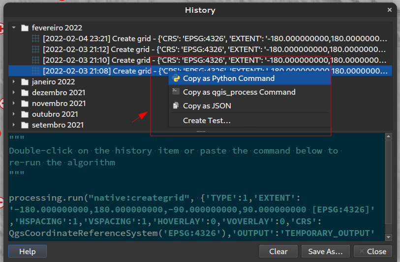
この機能は Research Institute for Nature and Forest, Flemish Govt によって資金提供されました
この機能は`Nyall Dawson <https://github.com/nyalldawson>`__ によって開発されました。
Feature: Advanced actions in Processing dialogs
We have added new actions on the processing dialog including copy as qgis_process command, and copy/paste as JSON. Together these actions:
Allows for easy copying of the equivalent PyQGIS command to run the tool using the parameters defined in the dialog
Allow for easy generation of qgis_process commands via the QGIS GUI, including any tricky parameter values like GeoPackage outputs with specific layers
Provide a way for you to copy the settings defined in the dialog in a text format, so that you can store these easily and then restore them later by pasting the values.
Provides an easy way for you to copy the settings into the JSON format consumed by qgis_process, so that it is easy to see the expected format even for complex parameters (like TIN interpolation parameters).
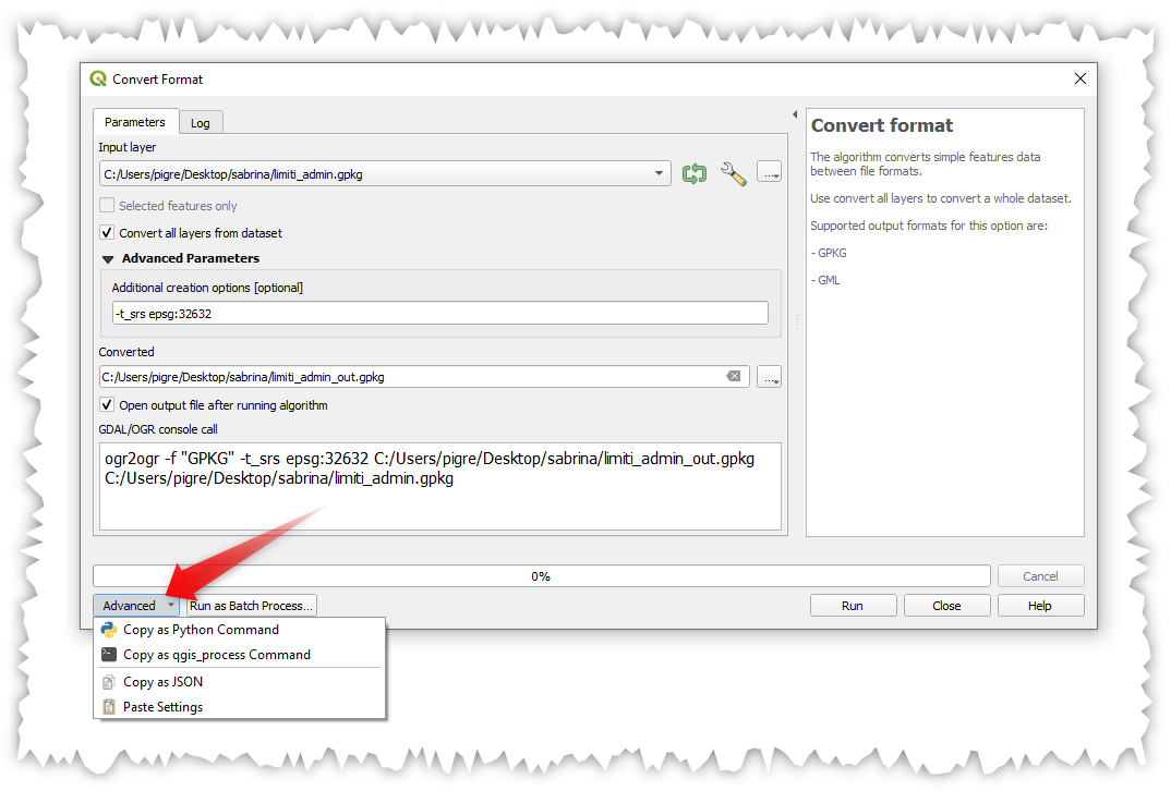
この機能は Research Institute for Nature and Forest, Flemish Govt によって資金提供されました
この機能は`Nyall Dawson <https://github.com/nyalldawson>`__ によって開発されました。
Feature: Single file exports from Atlas to PDF algorithm
You can now export an atlas layout to a single (collated) PDF file using the "Export atlas layout as PDF" processing algorithm.
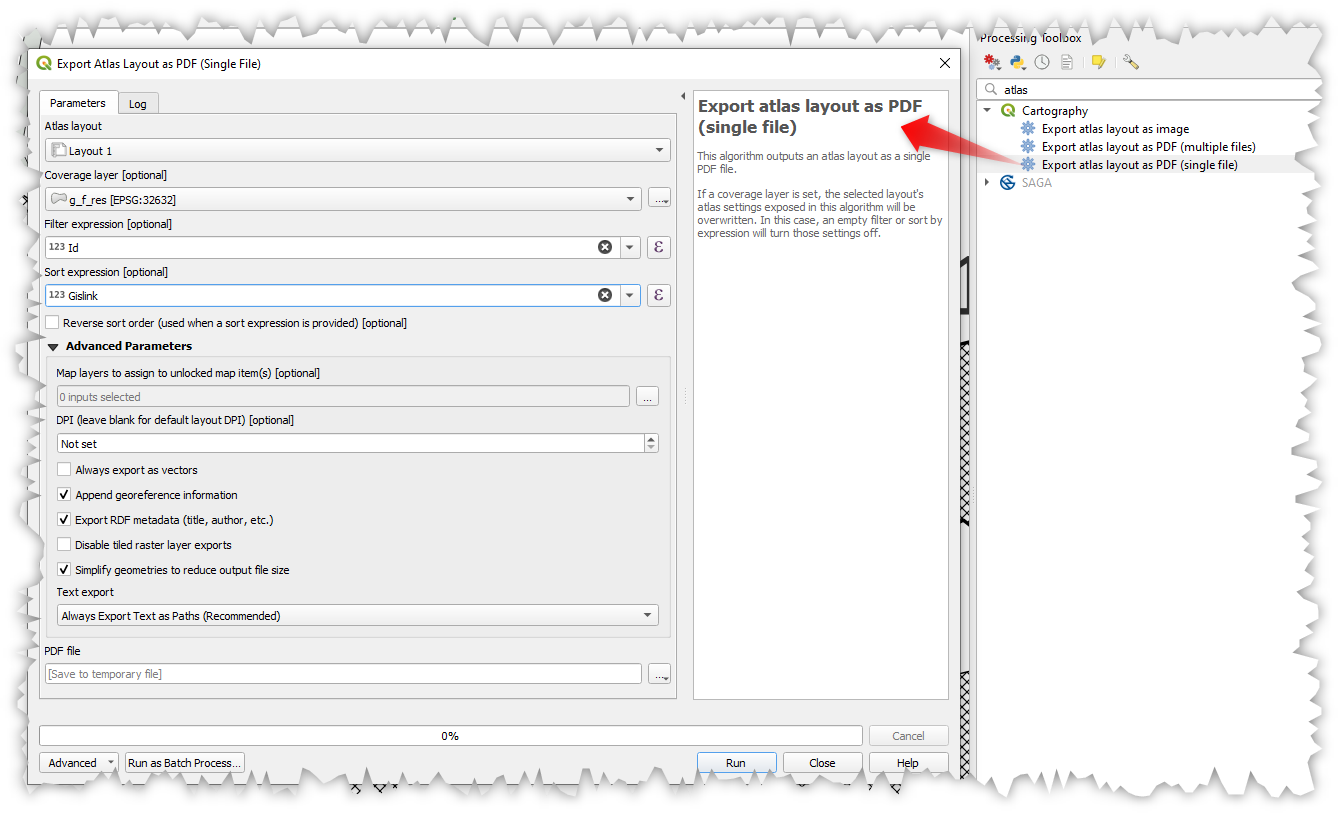
この機能は`Nyall Dawson <https://github.com/nyalldawson>`__ によって開発されました。
Feature: Project Models are shown in the Project menu
We added a new submenu to the "Project" menu, which will list any Processing models stored within the current project. This gives you a quick way to launch these project-specific models, in either a single or batch mode!
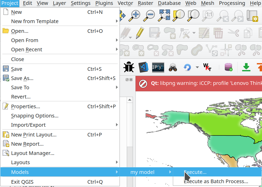
この機能は Kanton Solothurn によって資金提供されました
この機能は Alessandro Pasotti によって開発されました
Feature: Add point cloud destination parameter and output to Processing
We have extended and improved point cloud support in Processing, namely by:
Fixing the filtering of point cloud layers in
QgsProcessingMapLayerComboBox-based widget used for parametersAdding a destination point cloud parameter type and point cloud output types with corresponding widgets. (Currently these are useful for 3rd party providers and plugins which create point cloud outputs.)
Exposing the newly added point cloud output and destination parameters to the
algfactorywrapper
この機能は Alexander Bruy によって開発されました
Feature: Array field support
In QGIS 3.24, we've made array field types first-class citizen in the Processing toolbox! The following algorithms have all been updated to support array fields:
Refactor algorithm;
Aggregate algorithm;
Add field to attributes table algorithm;
Field calculator algorithm; and
Advanced (i.e. python) field calculator algorithm
この機能は SwissTierras Colombia によって資金提供されました
この機能は Mathieu Pellerin によって開発されました
アプリケーションとプロジェクトのオプション
Feature: qgis_process --no-python argument
This new, optional command line parameter for the qgis_process command-line tool allows you to skip launching Processing with Python support when it is not required. This can result in a significant improvement in qgis_process startup times!
この機能は North Road の資金提供によって開発されました。
この機能は`Nyall Dawson <https://github.com/nyalldawson>`__ によって開発されました。
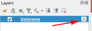
Feature: Suppress "bad layers" handler on startup
We've added support for a new command line flag for the qgis executable, which allows you to disable the default dialog which shows when opening a project with missing/broken layers:
[--skipbadlayers] don't prompt for missing layers
Example invocation: ./qgis --skipbadlayers or ./qgis -B
このユースケースは、自動化やその他の起動後のプロセスが発生し、プロジェクトに不良レイヤーが存在する場合に起動プロセスを中断したくない場合があります。起動後、QGISは欠落しているレイヤーを無視しますが、レイヤーリストでは壊れているという印が付きます。
この機能は、 2021年12月17日、QGIS Open Dayの期間に、Giuseppe Baiamonteによって提案され、ライブコーディングされました。
この機能は Tim Sutton によって開発されました
Feature: Parameter values for qgis_process can be specified as a JSON object via stdin
We now provide a mechanism to support complex input parameters for algorithms when running the qgis_process command line tool.
To indicate that parameters will be specified via stdin then the qgis_process command must follow the format
qgis_process run algid -
(with a trailing - in place of the usual arguments list).
The JSON object must contain an "inputs" key, which is a map of the input parameter values.
echo "{"inputs": {\"INPUT\": \"my_shape.shp\", DISTANCE: 5}}" | qgis_process run native:buffer -
Additionally, extra settings like the distance units, area units, ellipsoid and project path can be included in this JSON object:
{
    'ellipsoid': 'EPSG:7019',
    'distance_units': 'feet',
    'area_units': 'ha',
    'project_path': 'c:/temp/my_project.qgs'
    'inputs': {'DISTANCE': 5, ..... }
}
(Specifying input parameters via stdin implies automatically the --json output format for results.)
One big motivation behind this enhancement is to provide a way for the qgis_process R libraries to support parameter types such as aggregates!
この機能は Research Institute for Nature and Forest, Flemish Govt によって資金提供されました
この機能は`Nyall Dawson <https://github.com/nyalldawson>`__ によって開発されました。
Feature: Run Python script algorithms directly via qgis_process
The qgis_process command-line tool now supports running a Python script algorithm directly by specifying the path to the .py file, in place of an algorithm ID or model file path!
この機能は`Nyall Dawson <https://github.com/nyalldawson>`__ によって開発されました。
データプロバイダ
Feature: Friendlier errors from XYZ raster tiles, WMS and vector tiles
XYZ、ベクタータイル、またはWMSネットワークリクエスト中に発生するサーバーエラーは、メッセージバーを介してQGISウィンドウに直接表示されるようになりました。可能な限り元の応答エラーテキストを含めることで、これらのエラーメッセージをよりわかりやすく役立つものにしました。
この機能は MapTiler によって資金提供されました
この機能は Lutra Consulting (Vincent Cloarec) によって開発されました
Feature: Add out-of-the-box connection to Mapzen Global Terrain tiles
QGISでは現在、WMS/XYZレイヤー用のTerrariumDEMフォーマットの組み込みサポートを備えています。さらに、AWSでホストされているMapzen GlobalTerrainTilesをすぐに追加できるようになりました。新しいMapZenオプションは、ブラウザパネルのXYZセクションにあります。ユーザーは、プロジェクト用にすぐにアクセスできるグローバルDEMソースを利用できるようになりました。 https://registry.opendata.aws/terrain-tiles/ も参照してください
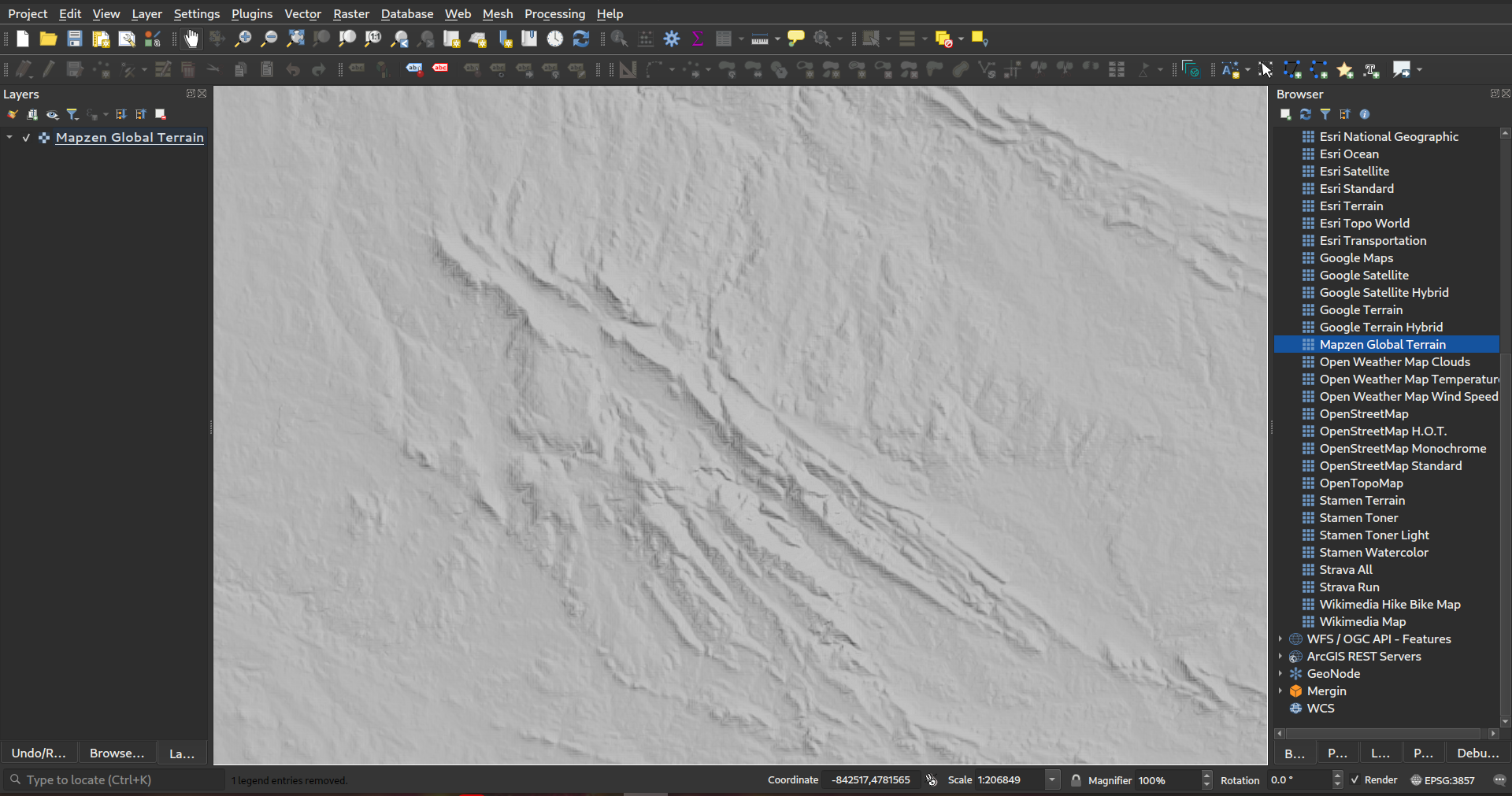
この機能は`Nyall Dawson <https://github.com/nyalldawson>`__ によって開発されました。
Feature: HMAC SHA256 auth method for MapTiler
We've added a new authentication method specific for MapTiler which allows you to use a token encrypted with HMAC-SHA256.
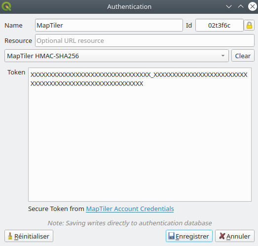
この機能は MapTiler によって資金提供されました
この機能は Lutra Consulting (Vincent Cloarec) によって開発されました
Feature: Template parameter {usage} for XYZ raster and vector tiles
For XYZ tile-based raster layers and for vector tile layers, we now allow the possibility to insert {usage} template parameters (in addition to {x}, {y}, {z}). If present, this parameter will be replaced by the context in which the request is being made.
The possible context values are:
view - when the request comes from 2D or 3D map canvas
export - when the request comes from exporting a layer or exporting a print layout for high-quality output (map previews in print layout designer are classed as “view”)
unknown - when coming from some other context, but the source is unknown
This functionality is useful for MapTiler clients, where they need to recognize the context in which tiles are used in order to bill users accordingly.
この機能は MapTiler によって資金提供されました
この機能は Lutra Consulting (Vincent Cloarec) によって開発されました
Feature: Convert WMTS/XYZ raster tiles to terrain (DEM)
In QGIS 3.24 we've introduced the possibility to convert WMTS/XYZ raster datasets to a raster layer of single band float type following a predefined encoding scheme.
You can activate this option and choose an encoding scheme (for now, "MapTiler Terrain RGB" or "Terrarium Terrain RGB" are available) in the source settings of the XYZ connection or in the Data Source Manager when adding a WMST layer.
選択したコンバーターは、RGBソース値を各ピクセルのフロート値に変換します。ロード後、レイヤーはシングルバンド浮動小数点ラスターレイヤーとして表示され、疑似カラーまたはヒルシェードレンダラーを使用してスタイリングできるようになります。
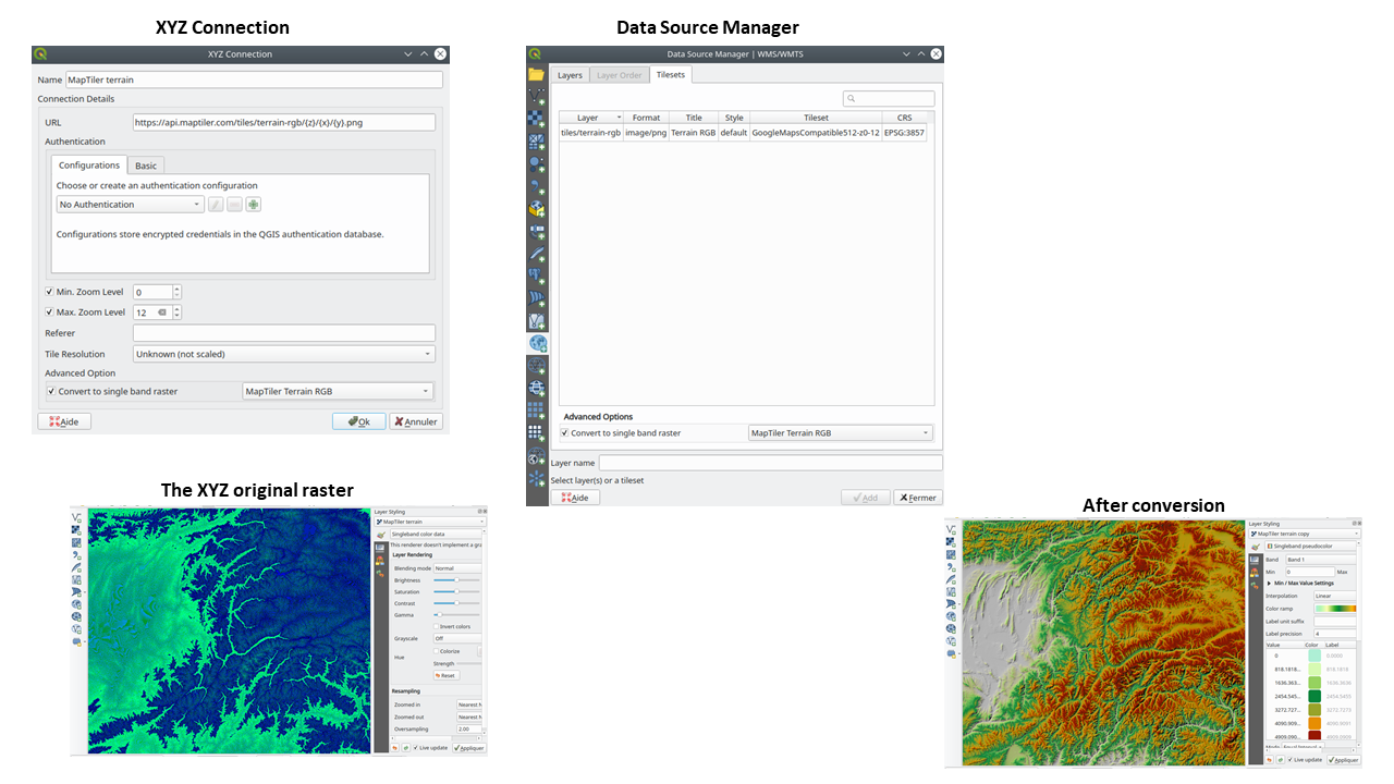
この機能は MapTiler によって資金提供されました
この機能は Lutra Consulting (Vincent Cloarec) によって開発されました
Feature: Array field types for scratch layers
You can now add array field types directly to newly created scratch layers. (While array field types have previously been supported by scratch layers, there was no way for users to add them when creating a new scratch layer.)
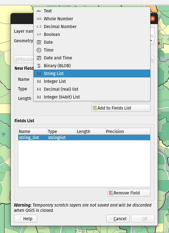
この機能は Mathieu Pellerin によって開発されました
Feature: JSON field types for new GeoPackage layers
We've added support for creating JSON fields directly to newly created GeoPackage layers. (While JSON field types have previously been supported by GeoPackage layers, there was no way for users to add them when creating a new layer.)
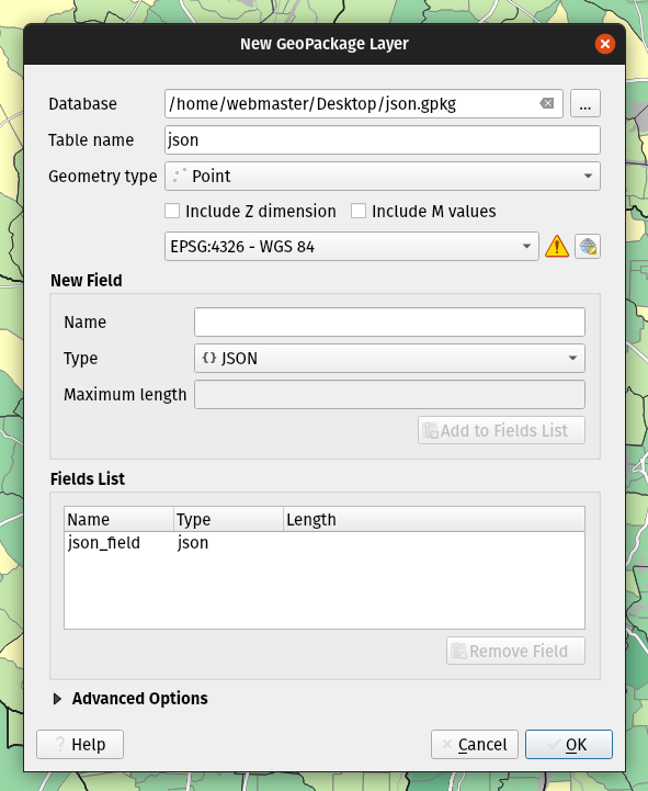
この機能は Mathieu Pellerin によって開発されました
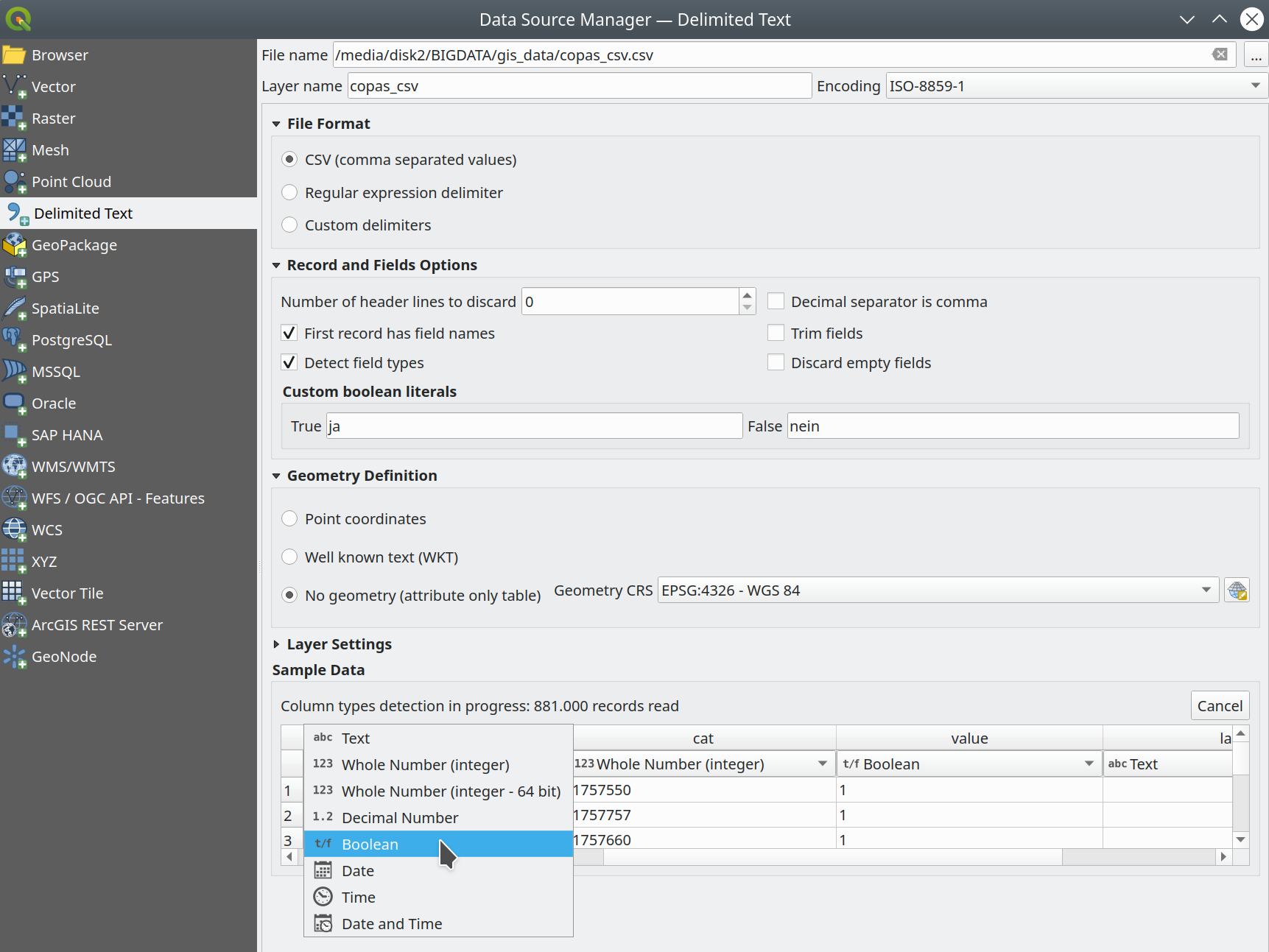
Feature: Delimited text type overrides and other improvements
We've given some love to the delimited text data provider in 3.24, with several enhancements which include:
Boolean type support and automatic detection
Boolean data types are now first-class citizens, which are automatically recognized when all records in a column contain one of the following values (case insensitive):
t/f
true/false
yes/no
0/1
Boolean fields are also detected from a CSVT file, a GDAL/GeoCSV format e.g.
Integer(Boolean)
You can also add custom string representations for TRUE/FALSE (for example a localized "yes"/"no" value).
Column type override
Column types are automatically determined (by an initial limited scan of the file for immediate feedback followed by a full scan of the file which happens in a separate thread to not block the GUI and is user-interruptible), the types are exposed to the GUI as combo boxes and the user can override the automatically determined types.
Enhanced CSVT support.
CoordX, CoordY, Point(X/Y), WKT are now recognized as specified in https://giswiki.hsr.ch/GeoCSV
この機能は Stadt Freiburg im Breisgau によって資金提供されました
この機能は Alessandro Pasotti によって開発されました
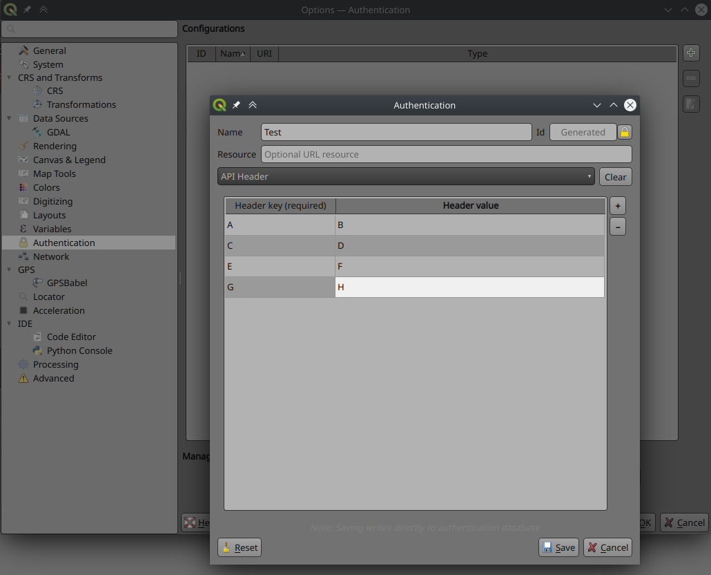
Feature: New authentication method for HTTP header based authentication
A new authentication method is available for network requests which that supports user defined HTTP header authentication. Multiple custom headers can be included in these requests.
This is useful in various scenarios, such as when a WMS requires an API key that is to be used in a HTTP header with the header key being X-API-KEY, which can now be included in requests from QGIS to authenticate against the WMS endpoint.
この機能は Tom C によって開発されました
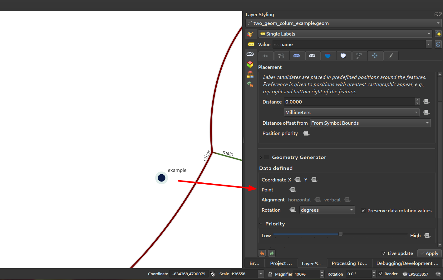
Feature: Expose secondary PostGIS geometry columns as referenced geometries
As discussed in this issue, we have added support for exposing additional geometry columns from the Postgres provider as QgsReferencedGeometry. This allows more efficient interaction with additional geometry columns through the API. For example, in label placement, the additional geometry column can be used instead of the feature geometry. The fields will be represented as WKT [CRS User-Friendly Identifier] in the attribute table.
This can be used in expressions and in the label placement properties tab where you can link the label placement to the second geometry column using the Point property. In the case where you using it for labelling, the second geometry column will be updated automatically if you use the move tool and the columnt type is Geometry. If the column type is text, you could also use that as a second geometry by doing e.g.
geom_from_wkt("my wkt string field")
In this case however, the column will be read only.
So e.g. now in expressions if you have secondary geometry column you can do:
buffer("my_second_geom_column", 10)
and it will work.
警告
This changes the behavior of existing projects.
この機能は OPENGIS.ch によって資金提供されました
この機能は Matthias Kuhn, OPENGIS.ch によって開発されました
QGISサーバー
Feature: Allow better control of the response flow chain from server filters
New filters allow control of the call chain by implementing new filter callbacks that allow returning a control value for stopping propagation. This allows for the better control of streamed data and response flow.
Deprecate
bool QgsFilter::onRequestReady(),bool QgsFilter::onSendResponse(),bool QgsFilter::onResponseComplete()Add new methods
bool QgsFilter::onRequestReady(),bool QgsFilter::onSendResponse(),bool QgsFilter::onResponseComplete()which return boolean values for controlling data flowHandle flow control in
QgsFilterResponseDecorator::flush()
この機能は David Marteau によって開発されました
注目すべき修正
Alessandro Pasotti によるバグ修正
バグの表題 |
URL issues.qgis.org (報告された場合) |
URL Commit (Github) |
3.22 backport commit (GitHub) |
|---|---|---|---|
Wrong raster projection on HIDPI screens |
TODO |
||
Data Source Manager title not translatable |
TODO |
||
QGIS 3.22 - Identical map names in print composer |
Works for me |
||
Bold and italic attributes of labels that reinitialize |
Works for me |
||
NameError: name 'QGISAPP' is not defined when using stop_app() |
Works for me on Linux/master, might be windows only |
||
Virtual layer not loaded correctly after re-opening a project |
TODO |
||
QGIS crashes while calling readLayerXml() |
Works for me |
||
Crash when changing orientation of page in layout |
TODO |
||
"sort" funcionality of attributes table sort numeric fields as text |
TODO |
||
OAPIF: api-key not included when requesting /collections endpoint |
TODO |
||
XML notation if missing from tooltips in vector file writer dialog |
TODO |
||
Ignore out of range option in interpolated symbol renderer creates artifacts if start value is out of range |
TODO |
||
start width > end width is ignored when using the "exact" color interpolation method |
TODO |
||
QGIS Layouts: using "Data defined override" for HTML Source URL not working |
works for me (closed - not a bug) |
||
(Un)force hide form in relation widget |
TODO |
||
Oauth2 authentication protocol does not honors the defined port number in redirect URL in QGIS 3.22.1 |
works for me (left open) |
||
HTML/String-ish QByteArray as result of expression function breaks expression preview display |
TODO |
||
Raster layer exported to GeoPackage with the character 'ß' in the name is not immediately loaded in the project |
works for me (closed) |
||
Layout Attribute Table sorting does not work in Print Layouts when column name has spaces |
TODO |
||
Incorrect scale range legend after applying logarithmic graduated symbology to a vector layer |
Risky? |
||
fix server crash |
未報告 |
TODO |
|
Load QGIS project from command line from a PostgreSQL project |
TODO |
||
Aggregate function with filter doesn't work in layout manager |
Works for me (closed) |
||
Value map widget: "value"/"description" inconsistency when table added to print layouts |
TODO |
||
Missing entries in attributetable in layout with atlas at page break |
TODO |
||
Server OAPIF: bbox filter isn't working if data source CRS is not EPSG:4326/WGS84 |
TODO |
||
Drag & Drop designer control visibility by expression with field IS NOT NULL doesn't work if the field is configured with html |
Risky? |
These bugfixes were funded by QGIS.ORG (through donations and sustaining memberships)
Alessandro Pasotti によるバグ修正
Sandro Santilliによるバグ修正
バグの表題 |
URL issues.qgis.org (報告された場合) |
URL Commit (Github) |
3.22 backport commit (GitHub) |
|---|---|---|---|
DistanceWithin algorithm failing with PostgreSQL provider |
|||
GH_WORKSPACE -> QGIS_WORKSPACE |
|||
Improve documentation about running tests |
|||
Use variables to set postgresql connection config in authmanager test |
|||
Re-use possibly cached postgis_version from pgsql description method |
|||
Trust primary key of layers setup by DBManager TopoViewer plugin |
|||
Improved debugging output in QgsPostgresConn class |
These bugfixes were funded by QGIS.ORG (through donations and sustaining memberships)
Sandro Santilli によるバグ修正
Even Rouaultによるバグ修正
バグの表題 |
URL issues.qgis.org (報告された場合) |
URL Commit (Github) |
3.22 backport commit (GitHub) |
|---|---|---|---|
QGIS 3.21.0: preset transform required "nehpgn.gsb" but downloads "nehpgn.tif" which does not work |
|||
Raster layer misaligns when bbox bigger than projected raster layer |
|||
Filter for WFS layer: The "Tables" button is missing |
バグではない |
||
Something simpler than SQL to filter a WFS layer |
|||
renaming/deleting columns takes a lot of time on large vectors |
|||
Opening a Vector Geopackage in QGIS alters its file even when no changes are done by user |
|||
MapInfo CRS not correctly recognized |
|||
Crash exporting dxf using "Symbol layer symbology" |
These bugfixes were funded by QGIS.ORG (through donations and sustaining memberships)
Even Rouault によるバグ修正
Denis Rouzaud によるバグ修正
バグの表題 |
URL issues.qgis.org (報告された場合) |
URL Commit (Github) |
3.22 backport commit (GitHub) |
|---|---|---|---|
Trying to add GPKG from data source manager crashes QGIS master |
無関係 |
||
Display name in layer properties is not automatically filled |
|||
Fixes to QgsGeometry::addPart + new test cases |
未報告 |
These bugfixes were funded by QGIS.ORG (through donations and sustaining memberships)
Bugs fixed by Denis Rouzaud
Alex Bruy によるバグ修正
バグの表題 |
URL issues.qgis.org (報告された場合) |
URL Commit (Github) |
3.22 backport commit (GitHub) |
|---|---|---|---|
Layout picture: data-defined svg parameters should be disabled for incompatible pictures |
|||
TypeError in MetaSearch when adding WFS data |
|||
Split Vector Layer algorithm does not export both null and empty values |
|||
data source manager not opening with correct sub menu for point cloud datasources |
|||
SLD import doesn't recognize html enconding in ttf font references |
|||
Error opening data loader dialog from MetaSearch |
Works for me |
||
Display name in layer properties is not automatically filled |
|||
No way to add mbtiles file-based MVT package except drag and drop |
|||
"GDAL rasterize overwrite with attribute" does not refresh/reload output |
|||
Delete Column in Matrix Parameter in Graphic Modeler not Working |
|||
Wrong signature of the QgsProcessingParameterMeshDatasetGroups when exporting to Python |
未報告 |
||
Error message when GRASS tools cannot be run is (now) wrong |
|||
"Ignore invalid input features" processing setting location is misleading |
|||
Inconsistent number of decimal places in Identify tool |
|||
qgis_process is not showing algorithm providers installed via a python plugin |
|||
Unable to delete files .shp and .dbf using python code (removeMapLayers, deleteShapeFile) |
Works for me |
||
QgsProcessingParameterFile extension option |
バグではない |
||
Make the labels "edit rule" widget a real dialog with buttons |
|||
Edit form python editor tabs/spaces confusion |
|||
Error when making buffer from empty layer with 'Dissolve result' option checked |
|||
QGIS does not replace commas in layer names when exporting to DXF (so is incompatible with AutoCAD) |
These bugfixes were funded by QGIS.ORG (through donations and sustaining memberships)
Bugs fixed by Alex Bruy
Bug fixes by Paul Blottiere
バグの表題 |
URL issues.qgis.org (報告された場合) |
URL Commit (Github) |
3.22 backport commit (GitHub) |
|---|---|---|---|
Fixes WFS EXP_FILTER parsing in GetFeature request |
Too risky |
||
Fix output filename when a raster is saved in a format without extension |
未報告 |
TODO |
|
WFS GetFeature document and exceptions |
未報告 |
TODO |
|
Exluding a print layout in project propteries -> server do not avoid that a GetPrint request can be done for that layout |
TODO |
||
Server: Can't enable WFS3 API update endpoint (PUT/PATCH) on layers without geometry |
Works for me |
These bugfixes were funded by QGIS.ORG (through donations and sustaining memberships)
Bugs fixed by Pau Blottiere
Bug fixes by Matthias Kuhn
バグの表題 |
URL issues.qgis.org (報告された場合) |
URL Commit (Github) |
3.22 backport commit (GitHub) |
|---|---|---|---|
Fix HTTP Post with MultiPart |
必要なし |
These bugfixes were funded by QGIS.ORG (through donations and sustaining memberships)
Bugs fixed by Matthias Kuhn
Nyall Dawsonによるバグ修正
バグの表題 |
URL issues.qgis.org (報告された場合) |
URL Commit (Github) |
3.22 backport commit (GitHub) |
|---|---|---|---|
Add .tsv extension to delimited text supported files filter |
reported on youtube screencast |
pending |
|
Fix line anchor placements are reversed for labels which sit below lines |
未報告 |
||
Fix incorrect return code from QgsProcessingModelAlgorithm::fromFile when file does not exist |
未報告 |
||
Fix many georeferencer regressions |
multiple |
未報告 |
pending |
Avoid some unwanted "unhandled exception" message boxes which can pop up while moving the mouse |
reported on youtube screencast |
||
Don't use custom palette in crash handler dialog, this results in unreadable text on dark themes |
|||
Don't slightly colorise the icons for selected items in lists |
not suitable |
||
Fix python exception raised after running in-place algorithm which requires no parameters |
reported on youtube screencast |
||
Fix labelling shown for features out of range of temporal controller dates |
|||
Fix line dependent orientation rendering of curved labels |
|||
When processing is initialized in external scripts, ensure the GRASS, SAGA and OTB providers are included by default |
|||
Show descriptive error when label rotation tool cannot be used because of invalid expressions |
not suitable |
||
QgsRasterDataProvider.block() returns invalid QgsRasterBlock if requested block size exceeds a certain threshold |
|||
Fix missing icons for array field types |
not suitable |
||
Use correct approach to unset data defined field for label position when auxiliary column is removed |
|||
Fix atlas sorting with complex field names |
|||
improve field handling when converting to rule-based |
|||
Fix 'Save all Styles/Save current Style' only appears after close/reopen the layer properties window |
not suitable |
||
Fix readability of text when using dark themes |
|||
Fix sqlite errors on startup caused by default style database import logic |
未報告 |
not suitable |
|
Fix color widgets incorrectly change colors when mouse is hovered over widget |
未報告 |
||
Avoid crs definition errors when closing options dialog |
n/a |
||
Fix duplicate shortcut registered warning on startup |
未報告 |
not suitable |
|
Fix scroll wheel events get "stuck" when scrolling to bottom of areas |
未報告 |
||
Flag a lot of situations where ballpark transforms are appropriate so warnings are not shown |
|||
Fix crashes when saving layer styles |
not suitable |
||
Fix broken merge features tool |
未報告 |
n/a |
|
[mssql] Fix provider on case-sensitive database locales |
|||
[mssql] Fix inserting features when pk attribute name contains special chars |
These bugfixes were funded by QGIS.ORG (through donations and sustaining memberships)
Nyall Dawson によるバグ修正
Damiano Lombardi によるバグ修正
バグの表題 |
URL issues.qgis.org (報告された場合) |
URL Commit (Github) |
3.22 backport commit (GitHub) |
|---|---|---|---|
Fix #47089 wrong rotation point for rotate label tool preview |
These bugfixes were funded by QGIS.ORG (through donations and sustaining memberships)
Damiano Lombardi によるバグ修正