QGIS ve GRASS, Yerel Yönetimler Orman Yanıgını Tehlike Haritalama’da.
Tanıtım
Güney Downs Bölgesel Konseyi (SDRC) güney doğu Queensland, Avustralya’da bir küçük-orta ölçekli yerel yönetimdir. Meclis özellikle bölgenin güney kısmında büyük orman yangınlarından muzdarip. Orman yangınları Güney Downs Bölgesi sakinleri ve arazi sahipleri için can ve mal kaybına ve gerçek bir endişeye neden olmuştur.
Bu proje, meclisin ve bölge halkının riskin farkında olmasına ve gelecekte daha iyi kararlar vermelerine katkıda bulunacaktır.
Proje
Orman yangını sadece SDRC için değil, aynı zamanda Queensland’ın tamamı için bir sorun olduğu gibi, eyalet hükümeti her yerel yönetim için Taşkın, Orman Yangını ve Heyelan’ıın Olumsuz Etkilerini Azaltıcı Devlet Planlama Politikası 03/01 yoluyla kendi alanında orman yangını tehlikesi tanımlamalarını gerektirir [1]. Normalde bu tür işler danışmanlar tarafından yapılabilir ama bunun yerine QGIS ve GRASS bir arada kullanılarak konseyin kendisi tarafından yapıldı.
Projenin CBS tarafı 6 ana adımla çökmüş
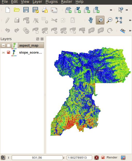
Şev değerlendirme ve haritalama
En boy değerlendirme ve haritalama
Bitki değerlendirme ve haritalama
Orman Yangınının ciddiyetini belirlemek için puanlar birleştirilir
Saha doğrulama ve nitel değerlendirme
Nihai Haritalar
QGIS ve GRASS kullanımı

QGIS, using the GRASS plugin, was selected as it provided the tools needed to complete the job and the interaction between QGIS and GRASS made it easy to process the raster maps and present them in a meaningful way to users. SDRC uses MapInfo for its main GIS system, however MapInfo’s addons were not as powerful as GRASS GIS for raster processing.
The QGIS GRASS plugin was used to import 5 meter contours of the whole region into GRASS which were then converted into a contour raster map using r.surf.contour. A slope and aspect map were then generated using r.slope.aspect from the raster contour map. Categories were assigned to different slope and aspect ranges and given a hazard risk sore. Vegetation areas were also given different risk scores. All the resulting raster maps were then combined using mapcalc and given a final risk hazard score. The risk scores are then divided into three main categories: high; medium; and low.
The final part of the process was field verification via the rural fire service. After the review process, QGIS was used to print the final maps for presentation.
As all GRASS commands can be run from the command line, all the commands that were needed to generate the bushfire hazard maps were recorded, for documentation purposes and for if the maps needed to be regenerated some time in the future.
Sonuç
Overall QGIS, together with the GRASS plugin, provided a great experience and a great final outcome for the council doing their own bushfire hazard mapping. The GRASS plugin provides a very easy to use interface to GRASS through QGIS. As QGIS is able to open the GRASS raster format natively, integration is very seamless and maps can be made with ease.
Proje 2010 yılında, Avustralya Queensland Planlama Enstitüsü devlet planlama ödülünü kazandı. [2]
Kaynaklar
Yazar

Nathan Woodrow
Bu makale Nathan Woodrow tarafından Ocak 2011’de katkıda bulunulmuştur. Nathan, Southern Downs Bölgesel Konseyi’nde bir CBS memuru ve Souther Queensland Üniversitesi’nde Mekansal Bilim ortak derecesi okuyor