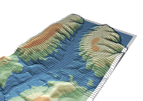
Jurnalul schimbărilor pentru QGIS 3.4 LTR

Data lansării: 2018-10-26
QGIS 3.4 tocmai a apărut. Prima versiune de QGIS 3 cu suport pe termen lung (LTR). După cinci versiuni de consolidare (3.4.5) va înlocui LTR-ul precedent în depozitele de pachete începând cu februarie 2019 (consultați programul lansărilor). Acesta este un salt uriaș înainte pentru proiect - prima noastră versiune, bazată pe platforma 3.x, cu suport pe termen lung. Pentru utilizatorii care trec de la 2.18 LTR, în această nouă versiune LTR există o listă uriașă de noi funcții și modificări cu impact semnificativ. Vă rugăm să rețineți că pluginurile 3.x sunt incompatibile cu pluginurile 2.x, așa că trebuie să verificați cu atenție utilizarea pluginurilor - iar, dacă este posibil, ajutați la migrarea pluginurilor vechi pe noua platformă. Dacă nu ați făcut deja acest lucru, aruncați o privire la jurnalele de modificări din Versiunea 3.0 și Versiunea 3.2 pentru a înțelege întregul scop al modificărilor din versiunea 3.4.
Mulțumiri
Dorim să mulțumim dezvoltatorilor, creatorilor documentației, testerilor și voluntarilor pentru timpul dedicat și pentru efortul depus (sau pentru că au finanțat anumite persoane în scopurile enumerate). Din partea comunității QGIS, sperăm să vă bucurați de această versiune! Dacă doriți să contribuiți cu efort, bani, sau să vă implicați într-un mod care ar putea îmbunătăți QGIS, vă rugăm să vizitați qgis.org și să oferiți o mână de ajutor!
QGIS este susținut prin donații și sponsorizări. Listă curentă a celor care au efectuat contribuții financiare mari și mici la proiect poate fi consultată în donors list. Dacă doriți să sponsorizați în mod oficial proiectul, vă rugăm să vizitați pagina membrilor susținători. Sponsorizările QGIS ne ajută să finanțăm întâlnirea dezvoltatorilor o dată la șase luni, să menținem infrastructura proiectului și să finanțăm eforturile de eliminare a erorilor. În continuare este prezentată lista completă a sponsorilor actuali - acestora le transmitem mulțumirile noastre!
QGIS este un soft gratuit iar dvs. nu aveți obligația de a plăti pentru folosirea lui - de fapt, vrem să încurajăm oamenii de pretutindeni să-l folosească, indiferent de starea financiară sau socială - având convingerea că, oferind utilizatorilor posibilități de decizie spațială, vom obține o societate mai bună.
Generalități
Funcționalitate: Flatpak
QGIS is now available as a flatpak application on flathub Flatpak (formerly xdg-app) is a software utility for software deployment, package management, and application virtualization for Linux desktop computers. It allows users to install different QGIS versions on linux without having to recompile or use Docker. It is a full package with all libraries included, and it uses its own user profile locations. So you’ll need some disk space and new habits working with flatpak, but it rocks!
Această funcționalitate a fost finanțată de Aleix Pol
Această funcționalitate a fost finanțată de Aleix Pol
Feature: SVG files can be embedded in projects and symbols
Allows SVG images for symbology, labels, etc to be directly embedded inside a project file (or QML style, or QPT print template!) by encoding the svg as a standard base64 string.
Additionally, embeded files can be extracted from projects and symbols and saved back to disk based SVG files.
Această funcționalitate a fost finanțată de SMEC/SJ
Această funcționalitate a fost dezvoltată de Nyall Dawson
Feature: OpenCL based acceleration
Această funcționalitate a fost finanțată de QGIS.org
Această funcționalitate a fost dezvoltată de Alessandro Pasotti
Expresii
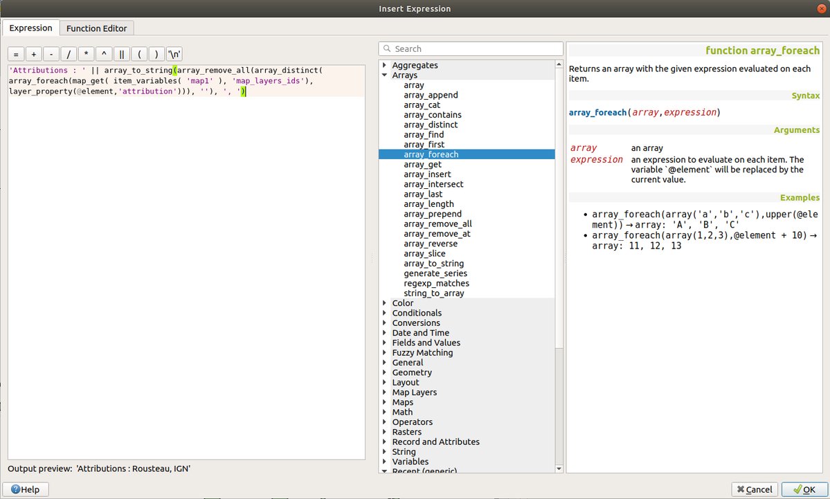
Feature: New expression functions and variables
Many new expression functions have been added in QGIS 3.4. These include many handy functions for working with and manipulating arrays and maps (dictionary) objects.
json_to_map: Converts a JSON encoded string value to a map (dictionary) type object
map_to_json: Converts a map (dictionary) type object to a JSON encoded string value
hstore_to_map: Converts a hstore value to a map (dictionary) type object
map_to_hstore: Converts a map (dictionary) type object to a hstore value
array_foreach : Loops over an array and executes an expression on each item in the array, returning a new array containing each calculated value
array_filter : Filters an array according to an expression
raster_value: Returns a value sampled from a raster layer at a specified point
to_dms: Converts a numeric value to a Degrees, Minutes, Seconds formatted string
to_dm: Converts a numeric value to a Degrees, Minutes formatted string
line_substring: Returns the portion of a line (or curve) geometry which falls between the specified start and end distances (measured from the beginning of the line). Z and M values are linearly interpolated from existing values.
generate_series(start,stop,step): Creates an array containing a sequence of numbers.
Additionally, some new variables have also been made available for use within QGIS expressions:
@canvas_cursor_point: Contains a point value representing the current position of the mouse cursor within the main map canvas
@map_layers: Contains an array of all layers which are visible within the map
@map_layer_ids: Contains an array of all layer IDs for layers visible within the map
Această funcționalitate a fost dezvoltată de `Etienne Trimaille, Matteo Ghetta, Matthias Kuhn, Mathieu Pellerin, Nyall Dawson <https://qgis.org>`___
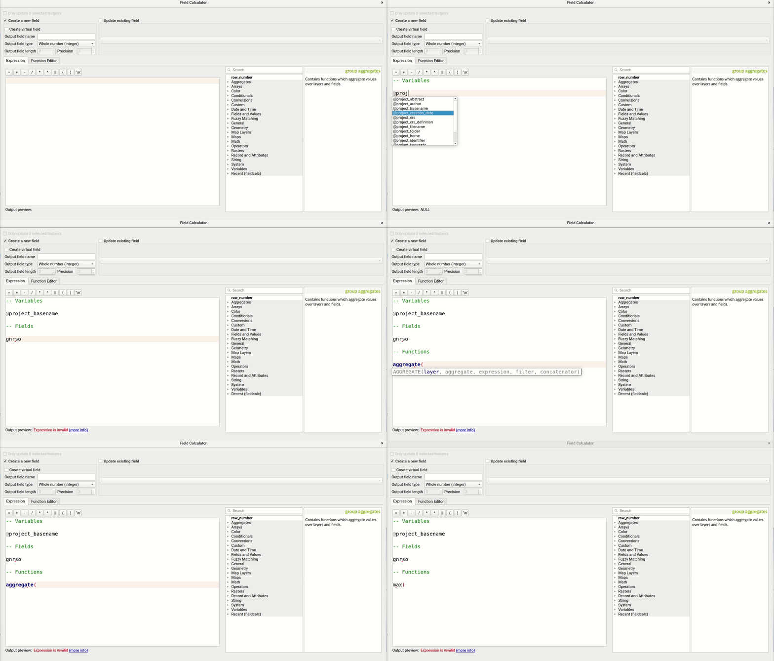
Feature: Code completion for expression builder
Autocompletion for code in the expression editor.
Variables, function names and field names are proposed and inserted automatically when writing expressions
Function parameters are shown while filling them
Această funcționalitate a fost finanțată de OPENGIS.ch
Această funcționalitate a fost dezvoltată de Matthias Kuhn (OPENGIS.ch)
Instrumente De Cartografiere
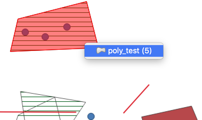
Feature: Identify or select features based on existing polygon
Often it is useful to select/identify features that are covered by an existing polygon. For this, users can use „Select Features by Polygon” and „Identify Features by Polygon” tools, but it was necessary to manually trace the polygon of interest. This new feature allows user to right click on the map and pick an existing polygon feature at that location from popup menu - that polygon will be used as input for selection or identification.
Această facilitate a fost finanțată de Leicestershire County Council
Această funcționalitate a fost dezvoltată de Peter Petrik (Lutra Consulting)
Interfața cu Utilizatorul
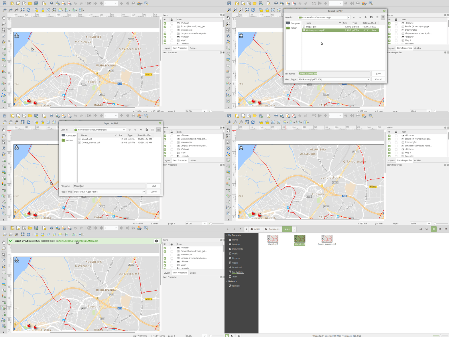
Feature: Auto selection of exported files in file manager
Whenever a message bar item links to a created file (e.g. after exporting a layout or map layer), the link will now directly open the folder containing this file within the operating system file browser AND pre-select the created file. It’s a super-handy shortcut speeding up file operations after an export from QGIS!
Această funcționalitate a fost finanțată de North Road
Această funcționalitate a fost dezvoltată de Nyall Dawson (North Road)
Feature: New „Open Directory” option for disabled welcome page projects
This new option in the right-click context menu for disabled entries on the welcome page allows users to open the closest existing path to the original project location in their file manager, to hopefully help them re-locate missing/moved/renamed projects.
Această funcționalitate a fost finanțată de North Road
Această funcționalitate a fost dezvoltată de Nyall Dawson (North Road)
Feature: UX Improvements for Temporary Scratch Layers
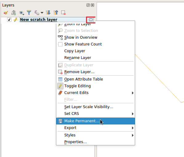
Temporary Scratch Layers in QGIS can be very handy when a „throw-away” layer is needed, such as when pre-processing data in multiple steps. However, they can be a trap for uniformed users who may not realise that the contents of the layer will be permanently lost when the current QGIS project is closed. Accordingly, a new indicator icon has been added which shows up next to any temporary scratch layers in the layer tree, making it immediately clear which layers are temporary only.
It’s also much easier to transition these temporary layers to permanent disk-based formats. You can either click the new indicator icon or select „Make Permanent” from the layer context menu. QGIS will then prompt for a location to save the temporary layer to, then replaces it in place (keeping the same layer ID, style, form settings, etc).
Această funcționalitate a fost finanțată de North Road
Această funcționalitate a fost dezvoltată de Nyall Dawson (North Road)
Feature: Task manager improvements
The QGIS task manager widget (shown in the status bar whenever a background task is running) now shows an estimated time remaining and completion time for long-running background tasks. This Estimated Time of Arrival is calculated using a simple linear interpolation based on the task’s elapsed time and current progress, and allows users to know whether they’ve only got time to make an instance coffee in the office kitchen or walk round the block for a proper barista made coffee before that long processing task completes…
Additionally, QGIS uses the standard operating system progress reporting mechanisms on more platforms and occasions in QGIS 3.4. Some long running tasks (which don’t run in the background) such as atlas exports now show their progress via the operating system mechanism, and throw up handy completion notifications.
Această funcționalitate a fost finanțată de North Road
Această funcționalitate a fost dezvoltată de Nyall Dawson (North Road)
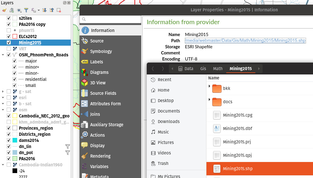
Feature: Hyperlinks to local vector & raster datasets in the information panel
For local vector and raster datasets, the Information tab within the layer properties dialog now features source file path hyperlinks. Upon clicking on the hyperlink, the system’s file navigator will open and automatically highlight the dataset.
Această funcționalitate a fost dezvoltată de iMhere Asia
Această funcționalitate a fost dezvoltată de Mathieu Pellerin
Feature: Style manager improvements
The QGIS Style Manager dialog (which allows users to setup and manage their own libraries of symbols and color ramps) now opens non-modally, so it can now be used alongside the main QGIS window (just like the Layout Manager dialog and Print Layout Designer windows).
We’ve also improved the preview of symbols within the Layer Styling dock, adding a toggle to switch between a large icon view and a detailed list view of symbols. Hovering over symbols (and colors!) now shows a large preview of the symbol. Finally, we’ve made symbol lists more hi-dpi friendly.
Această funcționalitate a fost finanțată de North Road
Această funcționalitate a fost dezvoltată de Nyall Dawson (North Road)
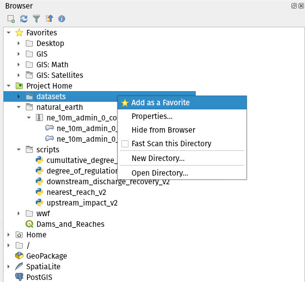
Feature: Polished browser panel interface and experience
Tons of work was done for this release to improve the user interface and experience of the browser panel including HiDPI fixes, compressed vector/raster dataset improvements, and a refreshed icon set.
Functionality has also been added, including the ability to create a new directory directly from the browser context menu. The browser also now shows a more complete range of options for SQL Server connections, matching those options which were already available for other database connections.
Această funcționalitate a fost dezvoltată de Mathieu Pellerin (iMHere Asia), Nyall Dawson (North Road)
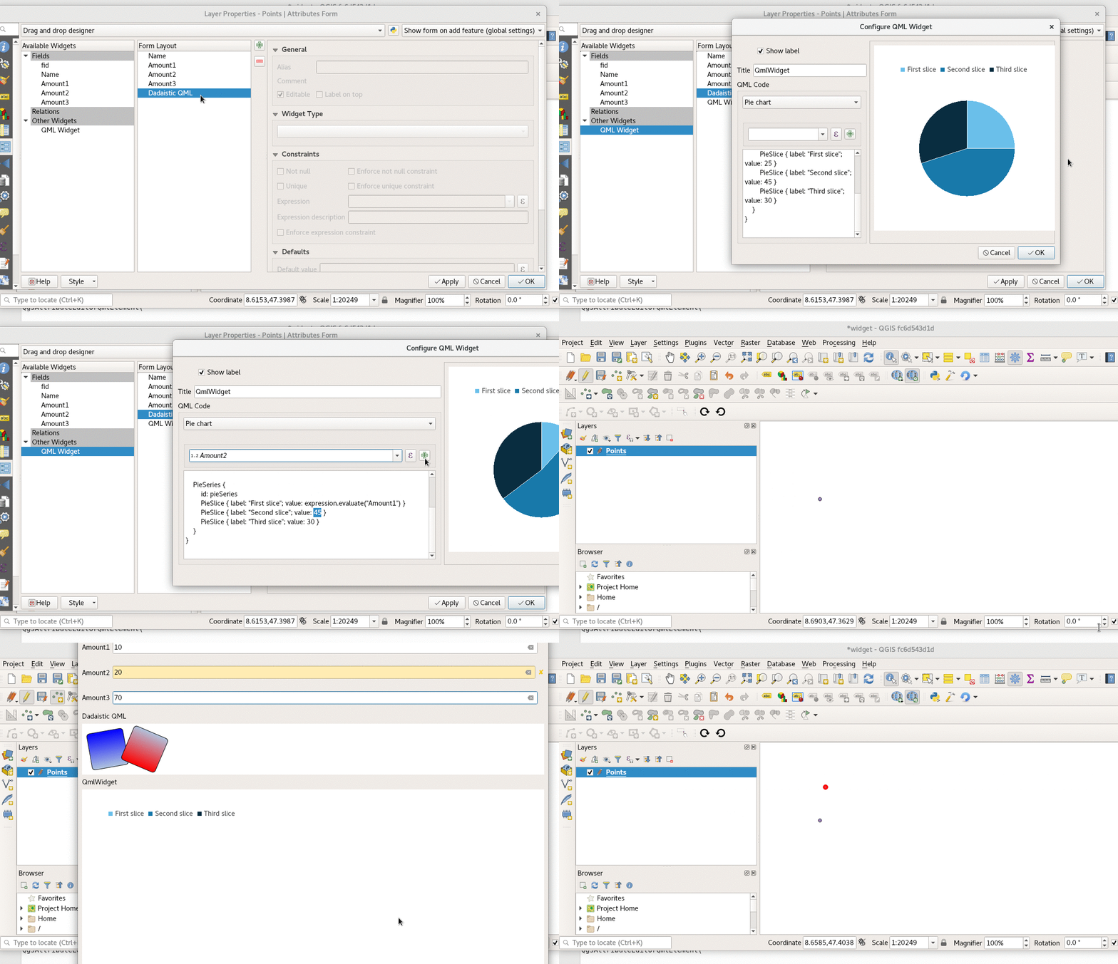
Feature: QML chart and drawings widget
A new type of vector layer form widget for showing graphically appealing and interactive items like charts or technical drawings on the attribute form has been added in QGIS 3.4. The widget sports a flexible configuration, including example templates and expression support.
Această funcționalitate a fost finanțată de QGIS Project
Această funcționalitate a fost dezvoltată de David Signer și Matthias Kuhn (OPENGIS.ch)
Simbologie
Feature: Mesh layer styling
Adding datasets to mesh layer from properties panel
Information and source panel in properties panel
Selection of active dataset (properties or styling panel)
Styling of contours/scalars (properties or styling panel)
Styling of mesh frame (properties or styling panel)
Styling of vector arrows (properties or styling panel)
Această funcționalitate a fost dezvoltată de Lutra Consulting
Această funcționalitate a fost dezvoltată de Peter Petrik (Lutra Consulting)
Feature: Classify symmetric in graduated renderer
Această funcționalitate a fost finanțată de https://github.com/pierreloicq
Această funcționalitate a fost finanțată de https://github.com/pierreloicq
Feature: Partial QML export and import
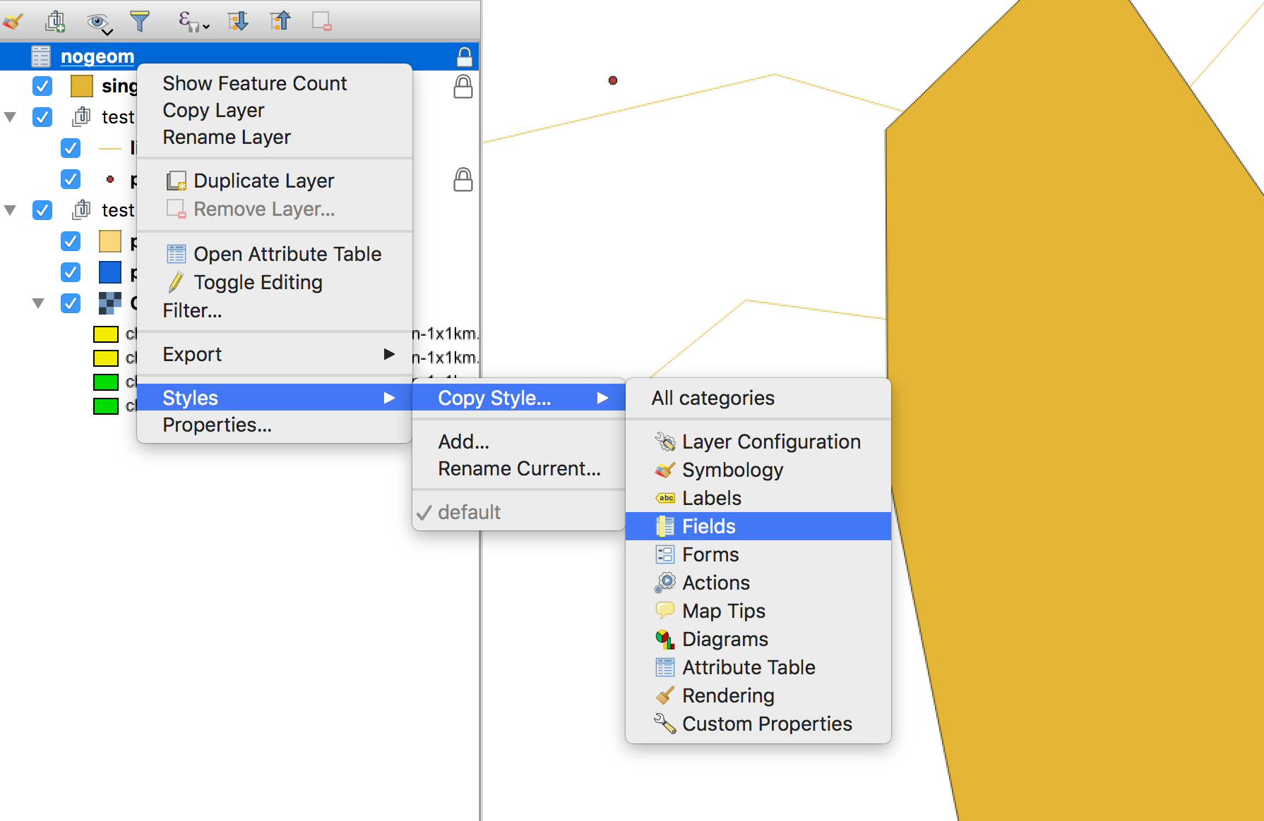
When exporting and importing styles to and from .qml files it is now possible to select a subset of sections.
This allows to save and restore parts of a layer configuration while omitting others. For example, it’s possible to export only the symbology of a layer and when importing this QML style file into a layer, any configuration on the forms and widgets or other properties are unaffected.
It is also possible to only handle single sections of a style when using copy/paste.
**Această funcționalitate a fost finanțată de grupul qwat
Această funcționalitate a fost dezvoltată de Denis Rouzaud (OPENGIS.ch GmbH)
Digitizarea
Feature: GPS tracking improvements
QGIS 3.4 extends the inbuilt GPS tracking support, adding „acquisition interval” and „distance threshold” parameters. These options can be used to keep the cursor stationary when the receiver is in static conditions.
Această funcționalitate a fost dezvoltată de Andrea Rossi
Această funcționalitate a fost dezvoltată de Andrea Rossi
Feature: More angle choices in advanced digitizing dock
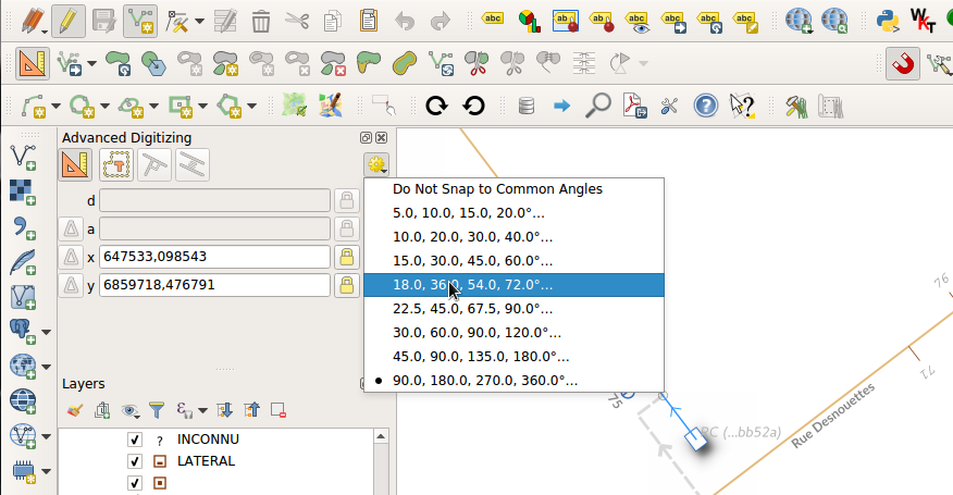
Options were added to allowing snapping to 5/10/15/18/22.5 degrees while in construction mode.
Această funcționalitate a fost finanțată de lbartoletti
Această funcționalitate a fost finanțată de lbartoletti
Feature: Vertex tool can work on the current layer only
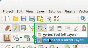
The new vertex is a lot more productive now. It can move vertices of all editable layers at once, which is great to preserve cross layers topology. However in many cases, many of us don’t want to modify all layers at once. We added a variation of the vertex map tool just for that.
Această funcționalitate a fost dezvoltată de Oslandia
Această funcționalitate a fost dezvoltată de Paul Blottiere (Oslandia)
Feature: Add reverse line maptools
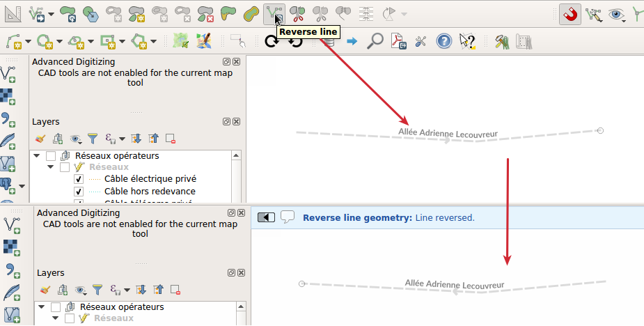
A long awaited feature ! No more external plugin or algorithm to reverse a line’s direction!
Această funcționalitate a fost dezvoltată de OSLANDIA
Această funcționalitate a fost finanțată de Loïc Bartoletti
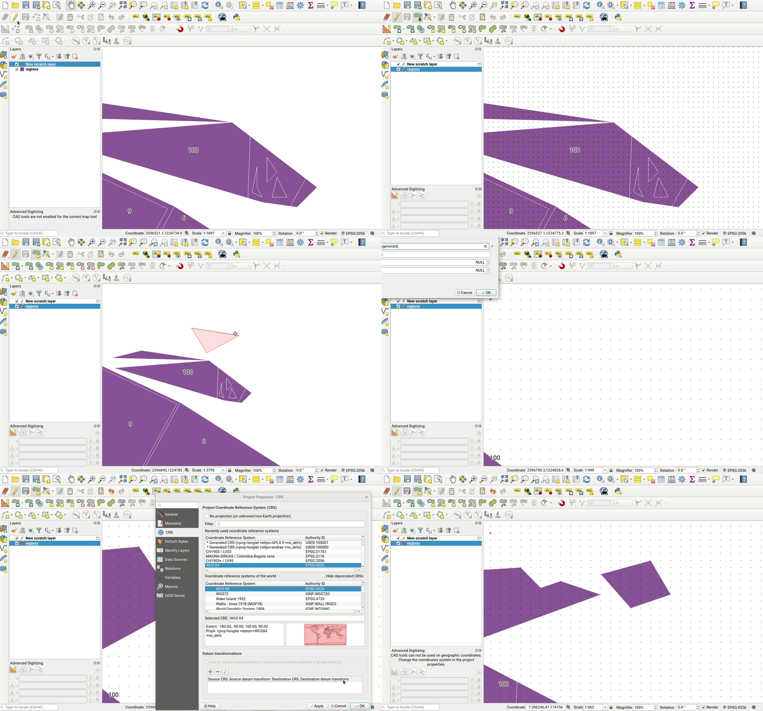
Feature: Geometry Precision
Vector layers have a precision configuration option. The precision defines how accurate the location of nodes should be saved. Each node of new or edited geometries is snapped to a grid of this resolution. While digitizing, the grid is shown to guide the user.
Această funcționalitate a fost finanțată de Kanton Solothurn
Această funcționalitate a fost dezvoltată de Matthias Kuhn (OPENGIS.ch)
Feature: Automatically remove duplicate nodes
When adding or editing geometries on a vector layer, QGIS can automatically remove duplicate nodes from geometries. This option is configurable in the digitizing tab of vector layers.
Această funcționalitate a fost finanțată de Kanton Solothurn
Această funcționalitate a fost dezvoltată de Matthias Kuhn (OPENGIS.ch)
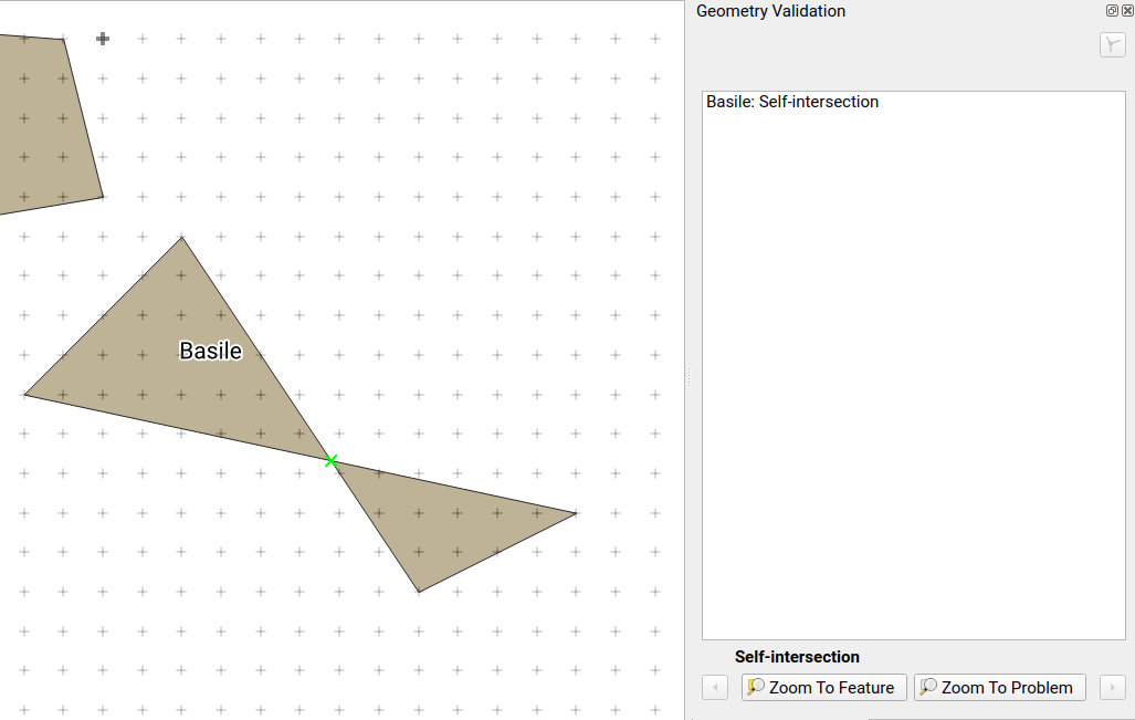
Feature: Check for geometry validity
Each new or edited geometry can be checked for validity if this option is activated. This allows to communicate transparently to a user when there are erroneous geometries produced by the current edit session.
Această funcționalitate a fost finanțată de Kanton Solothurn
Această funcționalitate a fost dezvoltată de Matthias Kuhn (OPENGIS.ch)
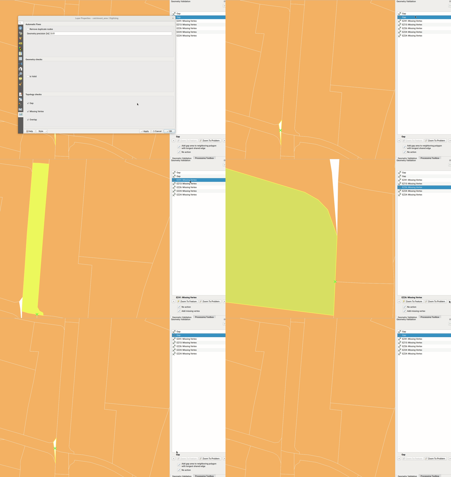
Feature: Topology checks while editing
Topology checks can be activated on a layer. On newly added and edited geometries, topology checks can be executed. The checks will be executed, when the layer is saved or upon a click on the topology check button on the geometry validation panel.
The following checks are available:
Gaps
Se suprapune
Missing vertices on neighbouring polygons
This builds on top of the functionality of the geometry checker plugin which was implemented by Sourcepole.
Această funcționalitate a fost finanțată de Kanton Solothurn
Această funcționalitate a fost dezvoltată de Matthias Kuhn (OPENGIS.ch)
Gestiunea Datelor
Feature: Translation of QGIS projects
Like QGIS and the plugins, the projects are translated with the Qt translation process. Means, it makes the translation according to a Qt Compiled Translation Source File (.qm file). When the user opens a project, QGIS checks for a .qm file laying in the same folder like the .qgs file, having the same name like the .qgs file and having the language-code as postfix of the users language (the language configured in the QGIS settings).
To create the translation, in the project settings, there is an option to generate the .ts file, that can edited by programs like Qt Linguist or Transifex.
Mai multe informații sunt disponibile în postarea de pe acest blog
Această funcționalitate a fost finanțată de Grupul Utilizatorilor Elvețieni de QGIS și de Proiectul QGEP
Această funcționalitate a fost dezvoltată de David Signer (OPENGIS.ch)
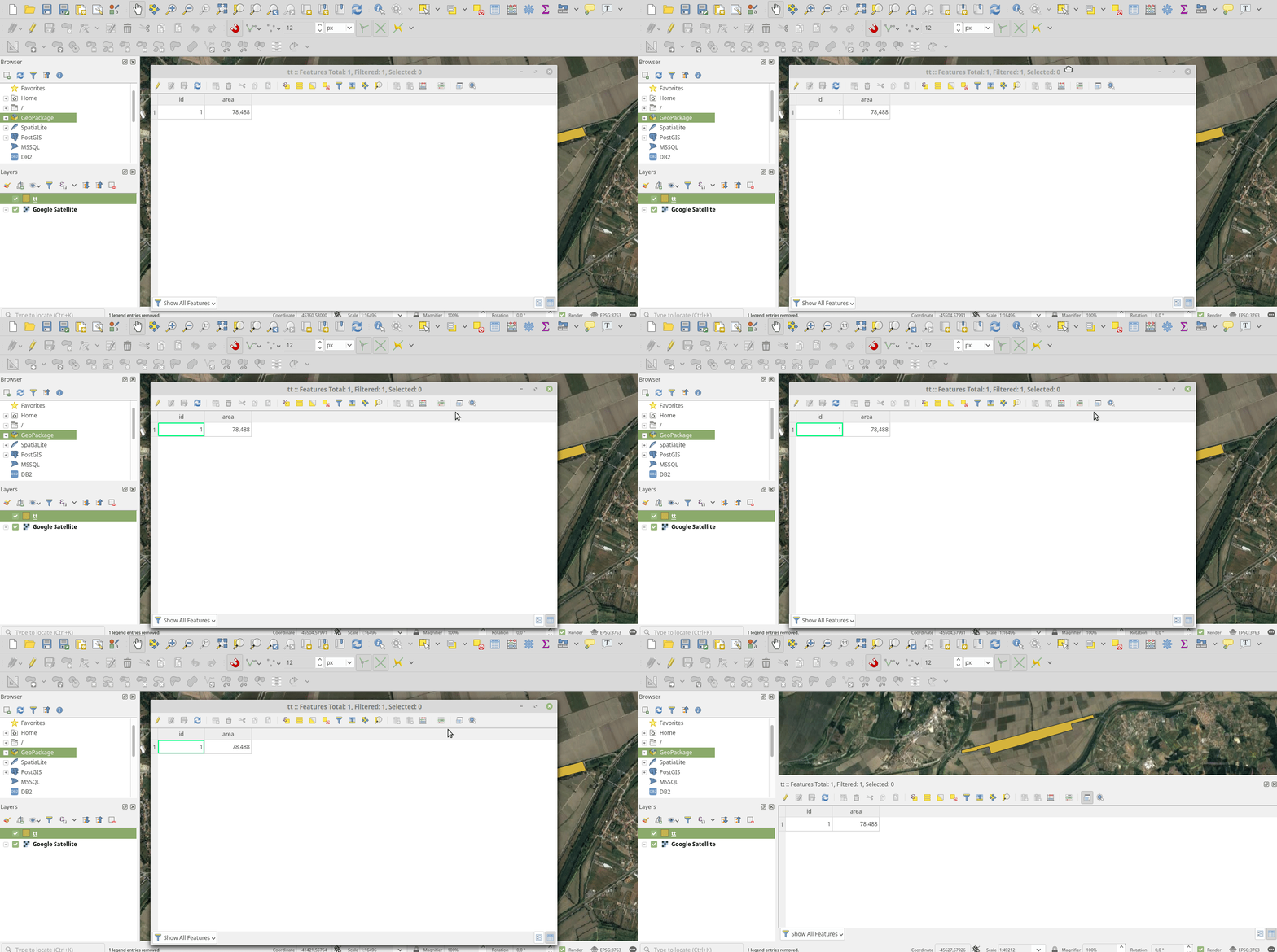
Feature: Switch Attribute Table dock mode on demand
A button has been added to the Attribute Table toolbar for switching between docked and window mode on demand. Previously users had to change an option in the settings dialog and open a new table in order to switch between docked/undocked mode, but that’s painful if you decide after a table is already open that you’d like to dock/undock it…!
Această funcționalitate a fost finanțată de North Road
Această funcționalitate a fost dezvoltată de Nyall Dawson (North Road)
Feature: New locator filter to search across all layers
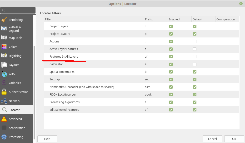
A new locator filter has been added which allows users to search across all layers in their project, by the layer’s display expression.
The filter can be activated by using the prefix «af», or by making it a default search via QGIS options -> Locator -> Features In All Layer. Display expressions are defined in the vector layer properties under the display tab. Individual layers can be marked as not searchable in the Project Properties dialog, under the Data Sources tab.
Această funcționalitate a fost finanțată de Opengis.ch
Această funcționalitate a fost dezvoltată de Denis Rouzaud
Feature: Non-removable (required) layers highlighted in layer tree
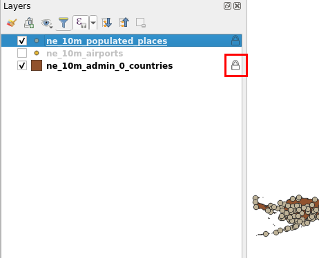
A new indicator „locked” icon is shown for any layers marked as „required” within the current project. This icon gives users instant feedback that a particular layer cannot be removed from the project.
Required layers are configured via the Project Properties dialog, Data Sources tab.
Această funcționalitate a fost finanțată de Arpa Piemonte (Dipartimento Tematico Geologia e Dissesto) within ERIKUS project
Această funcționalitate a fost dezvoltată de Martin Dobias (Lutra Consulting) and Faunalia
Feature: Append raster layer to an existing Geopackage
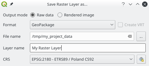
When saving a raster layer to GeoPackage database, it’s now possible to append the layer to an existing file.
Această funcționalitate a fost finanțată de Borys Jurgiel
Această funcționalitate a fost finanțată de Borys Jurgiel
Formulare și Controale grafice
Feature: Drill-down (cascading) forms in QGIS Value Relation Widgets
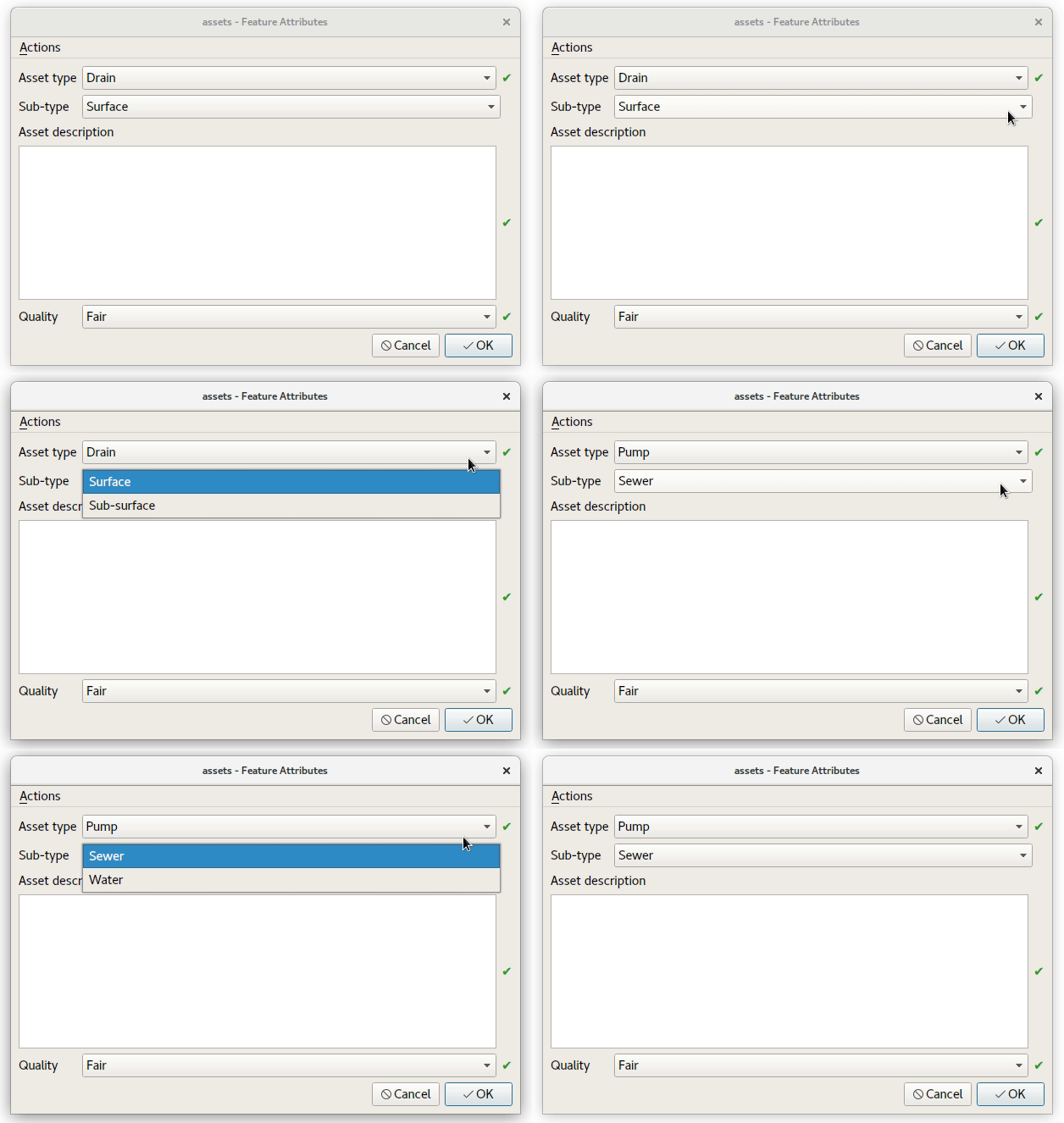
New functions and logic in QGIS “Value Relation Widgets”, allowing the implementation of complex, dynamic filters within QGIS attribute forms. The functionality can be used to implement “drill-down” forms within QGIS, where the values available in one field depend on the values of other fields:
Această funcționalitate a fost finanțată de Comunitatea QGIS community printr-o campanie de finanțare
Această funcționalitate a fost dezvoltată de Alessandro Pasotti (cu sprijinul North Road)
Compozitorul de Hărți
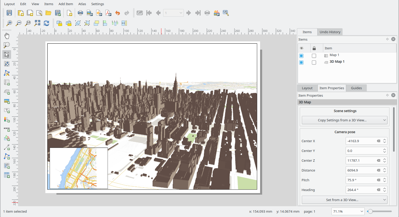
Feature: 3D map items
This feature allows users to add their 3D map view to the print layout.
Această funcționalitate a fost finanțată de Comunitatea QGIS community printr-o campanie de finanțare
Această funcționalitate a fost dezvoltată de Lutra Consulting
Procesare
Feature: New „Edit in place” mode
Thanks to a large number of generous backers, a crowdfunded „edit in place” mode was added to Processing for 3.4. When a vector layer is active and editable, this mode allows users to execute suitable algorithms directly on the features from the layer, modifying their attributes and geometries in-place. All edits are added to the layer’s “edit buffer”, so you can easily undo and redo the changes before saving them back to the data source.
For those power users who perform frequent data edits, this functionality is also exposed via QGIS 3.0’s “Locator bar” (that “type to locate” bar which sits in the bottom-left corner). Typing ‘ef’ (“edit features”) followed by the name of the corresponding operation allows you to perform the edits directly via the keyboard. E.g.
Select a bunch of line features
Press Ctrl + K (activates the locator bar)
Type “ef reverse”
Press enter – the selected line features will be reversed immediately!
Această funcționalitate a fost finanțată de Crowdfunding campaign
Această funcționalitate a fost dezvoltată de North Road
Feature: Store models inside project
Some Processing models are so intrinsically linked to the logic inside a particular project that they have no meaning (or are totally broken) outside of that project (e.g. models which rely on the presence of particular map layers, relations, etc). Accordingly, from QGIS 3.4, Processing models can be stored inside QGIS project files. Any models stored within a project are made available as soon as that project is opened. This also avoids cluttering up the „global” model provider with models which make no sense, and makes it easier to distribute a single project all relevant models included.
Models are stored inside projects by clicking the new „Embed in Project” button in the Modeler dialog toolbar. Models can be removed from a project from the model’s right click menu in the toolbox.
Această funcționalitate a fost finanțată de North Road
Această funcționalitate a fost dezvoltată de Nyall Dawson (North Road)
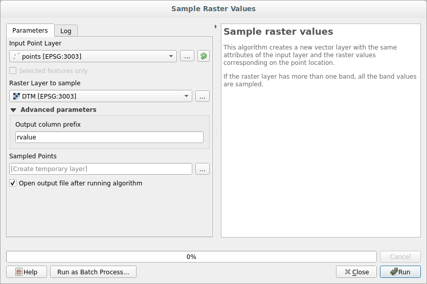
Feature: Sample Raster Values
A new algorithm was added for sampling raster layer values at point locations.
Această funcționalitate a fost dezvoltată de Faunalia
Această funcționalitate a fost dezvoltată de Matteo Ghetta (Faunalia)
Feature: New «Raster pixels to polygons» algorithm
This algorithm converts a raster layer into a vector layer, with a polygon feature corresponding to each pixel from the raster and a single field containing the band value from the raster.
Această funcționalitate a fost finanțată de SMEC/SJ
Această funcționalitate a fost dezvoltată de Nyall Dawson
Feature: K Means clustering algorithm
QGIS 3.4 adds a native „k-means clustering” algorithm. Based on a port of PostGIS» ST_ClusterKMeans function, this algorithm adds a new cluster ID field to a set of input features which identifies the feature’s cluster based on a k-means clustering approach. If non-point geometries are used as input, the clustering is based off the centroid of the input geometries.
Această funcționalitate a fost finanțată de North Road
Această funcționalitate a fost dezvoltată de Nyall Dawson (North Road)
Feature: dbscan spatial clustering algorithm
This new native algorithm implements an optimised DBSCAN density based scanning cluster approach for clustering 2d point features.
Această funcționalitate a fost finanțată de North Road
Această funcționalitate a fost dezvoltată de Nyall Dawson (North Road)
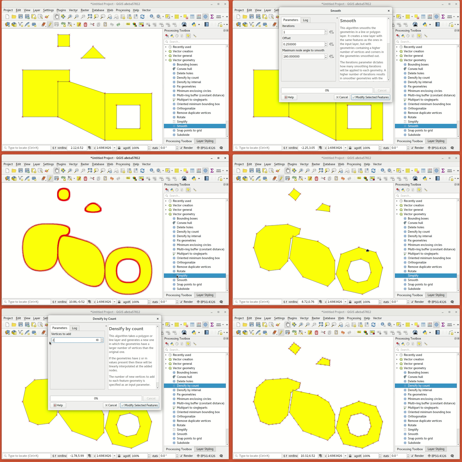
Feature: Improved algorithms
Some miscellaneous improvements to existing Processing algorithms include:
The Reverse line direction algorithm now works with MultiLineString geometry inputs
Extend lines: support for dynamic (data defined) start and end distances was added
Offset lines: support for dynamic offset distance was added
The Join by Field Value and Join by Location algorithms can now optionally export unmatched records
Join by Field Value also reports counts of matched/unmatched features
Această funcționalitate a fost finanțată de North Road
Această funcționalitate a fost dezvoltată de Nyall Dawson (North Road)
Feature: Filter Vertices by M and Filter Vertices by Z algorithms
Two new algorithms were added for filtering line/polygon vertices by their M or Z values. A minimum and maximum M/Z value can be entered, and if the vertices fall outside these ranges they will be discarded from the output geometry. Both the minimum and maximum filter values can also be data defined, so can vary per feature.
Această funcționalitate a fost finanțată de North Road
Această funcționalitate a fost dezvoltată de Nyall Dawson (North Road)
Feature: „Array of Translated Features” algorithm
This new algorithm creates copies of features in a layer, by creating multiple translated (offset) versions of the feature. Each copy is displaced by a preset amount in the x/y/z/m axis.
Această funcționalitate a fost finanțată de North Road
Această funcționalitate a fost dezvoltată de Nyall Dawson (North Road)
Feature: „Array of offset (parallel) lines” algorithm
This new algorithm creates copies of line features in a layer, by creating multiple parallel versions of each feature. Each copy is offset by a preset distance.
Această funcționalitate a fost finanțată de North Road
Această funcționalitate a fost dezvoltată de Nyall Dawson (North Road)
Feature: Choice of units for non degree/unknown distances
When an algorithm has a distance parameter in meters/feet/etc (i.e. non-geographic distances), a combo box has been added allowing choice of the unit type.
(QGIS doesn’t (and should never) expose this for distances in degrees – it’s up to users in this situation to choose a suitable local projection and reproject their data to match.)
Această funcționalitate a fost finanțată de North Road
Această funcționalitate a fost dezvoltată de Nyall Dawson
Feature: „Drape features to z/m” algorithms
These two new algorithms can set geometry vertex z or m values to values sampled from a raster band. Values can optionally be scaled using a (data definable) scale value.
Această funcționalitate a fost finanțată de North Road
Această funcționalitate a fost dezvoltată de Nyall Dawson (North Road)
Feature: „Raster pixels to points” algorithm
A new „pixels to points” algorithm was added in QGIS 3.4, which creates a point feature at the center of every pixel. nodata pixels are skipped.
Această funcționalitate a fost finanțată de North Road
Această funcționalitate a fost dezvoltată de Nyall Dawson (North Road)
Feature: Line substring algorithm
This new, much-requested, algorithm returns the portion of a line (or curve) which falls between the specified start and end distances (measured from the beginning of the line). Z and M values are linearly interpolated from existing values.
Această funcționalitate a fost finanțată de North Road
Această funcționalitate a fost dezvoltată de Nyall Dawson (North Road)
Feature: „Interpolate point on line” algorithm
This new algorithm creates a point geometry interpolated at a set distance along line (or polygon boundary) geometries. Curved input geometries are fully supported. Z or M values are linearly interpolated based on existing values.
Această funcționalitate a fost finanțată de North Road
Această funcționalitate a fost dezvoltată de Nyall Dawson (North Road)
Feature: k-neighbour concave hull
Această funcționalitate a fost finanțată de https://qgis.org
Această funcționalitate a fost dezvoltată de Detlev Neumann, Rudi von Staden
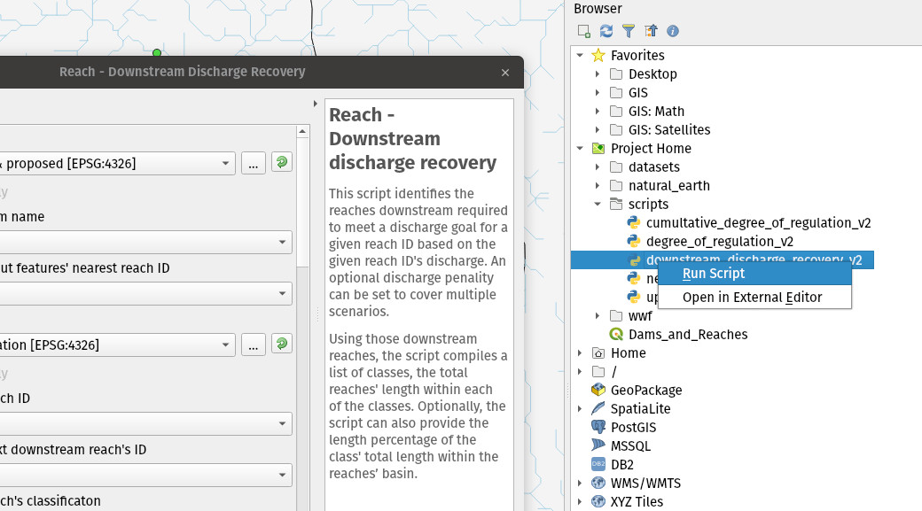
Feature: Python scripts which implement algorithms now execute the algorithm on drag and drop and browser double click
When appropriate, scripts will now launch a processing algorithm dialog upon:
Dragging and dropping a Python script onto the main window
Using the browser panel’s right-click run script action
Această funcționalitate a fost dezvoltată de iMhere Asia
Această funcționalitate a fost dezvoltată de Mathieu Pellerin
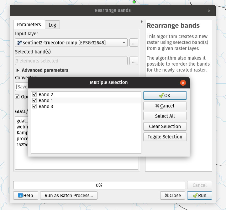
Funcționalitate: Nou algoritm GDAL de rearanjare a benzilor
A new GDAL provider «Rearrange band» algorithm was added to the processing toolbox. The algorithm allows to output rasters continuing a subset of a given input raster’s bands, and offers the possibility to re-order the bands.
Această funcționalitate a fost dezvoltată de iMHere Asia
Această funcționalitate a fost dezvoltată de Mathieu Pellerin
Feature: „Precalculated” values for model algorithm parameters
A new option is present for all parameters of using a „precalculated expression”. This expression is evaluated once before the child algorithm is executed and used during the execution of that algorithm.
Această funcționalitate a fost finanțată de QGIS
Această funcționalitate a fost dezvoltată de Nyall Dawson (North Road)
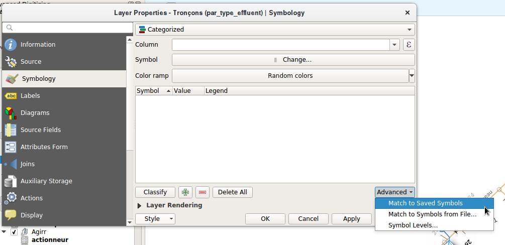
Feature: „Categorize a layer using a style XML file” algorithm
This new algorithm sets a vector layer’s renderer to a categorized renderer using matching symbols from a style database.
A specified expression (or field name) is used to create categories for the renderer, with QGIS creating a category for each unique value within the layer. Each category is individually matched to the symbols which exist within the specified QGIS XML style database. Whenever a matching symbol name is found, the category’s symbol will be set to this matched symbol.
The matching is case-insensitive by default, but can be made case-sensitive if required. Optionally, non-alphanumeric characters in both the category value and symbol name can be ignored while performing the match. This allows for greater tolerance when matching categories to symbols.
If desired, tables can also be output containing lists of the categories which could not be matched to symbols, and symbols which were not matched to categories.
Această funcționalitate a fost finanțată de North Road
Această funcționalitate a fost dezvoltată de Nyall Dawson (North Road)
Funcționalitate: Mod nou pentru algoritmul de Acroșare a geometriilor
The new mode „Snap to anchor nodes (single layer only)” makes sure that any two vertices of the vector layer are at least at distance given by the threshold value.
This algorithm comes handy when doing vector overlay operations such as intersection, union or difference to prevent possible topological errors caused by numerical errors if coordinates are very close to each other. After running the algorithm some previously valid geometries may become invalid and therefore it may be useful to run Fix geometries algorithm afterwards.
Această funcționalitate a fost finanțată de InaSAFE DFAT
Această funcționalitate a fost dezvoltată de Martin Dobias (Lutra Consulting)
Furnizorii de Date
Feature: OAuth2 authentication method plugin
Supports authentication code, implicit and resource owner grant flows
Allows for preconfigured connections, read from default locations
Offers caching of access token beyond QGIS restarts
Save/load configurations
Această funcționalitate a fost finanțată de Monsanto Company
Această funcționalitate a fost dezvoltată de Larry Shaffer, Alessandro Pasotti
Feature: Mesh layer: New mesh layer format support
Mesh layers represent data on variable size grid with extra components (e.g. time and vector). With introduction of MDAL, users can load the following formats directly in QGIS and explore all other components:
GRIB
XMDF
Netcdf
Această funcționalitate a fost dezvoltată de Lutra Consulting
Această funcționalitate a fost dezvoltată de Lutra Consulting
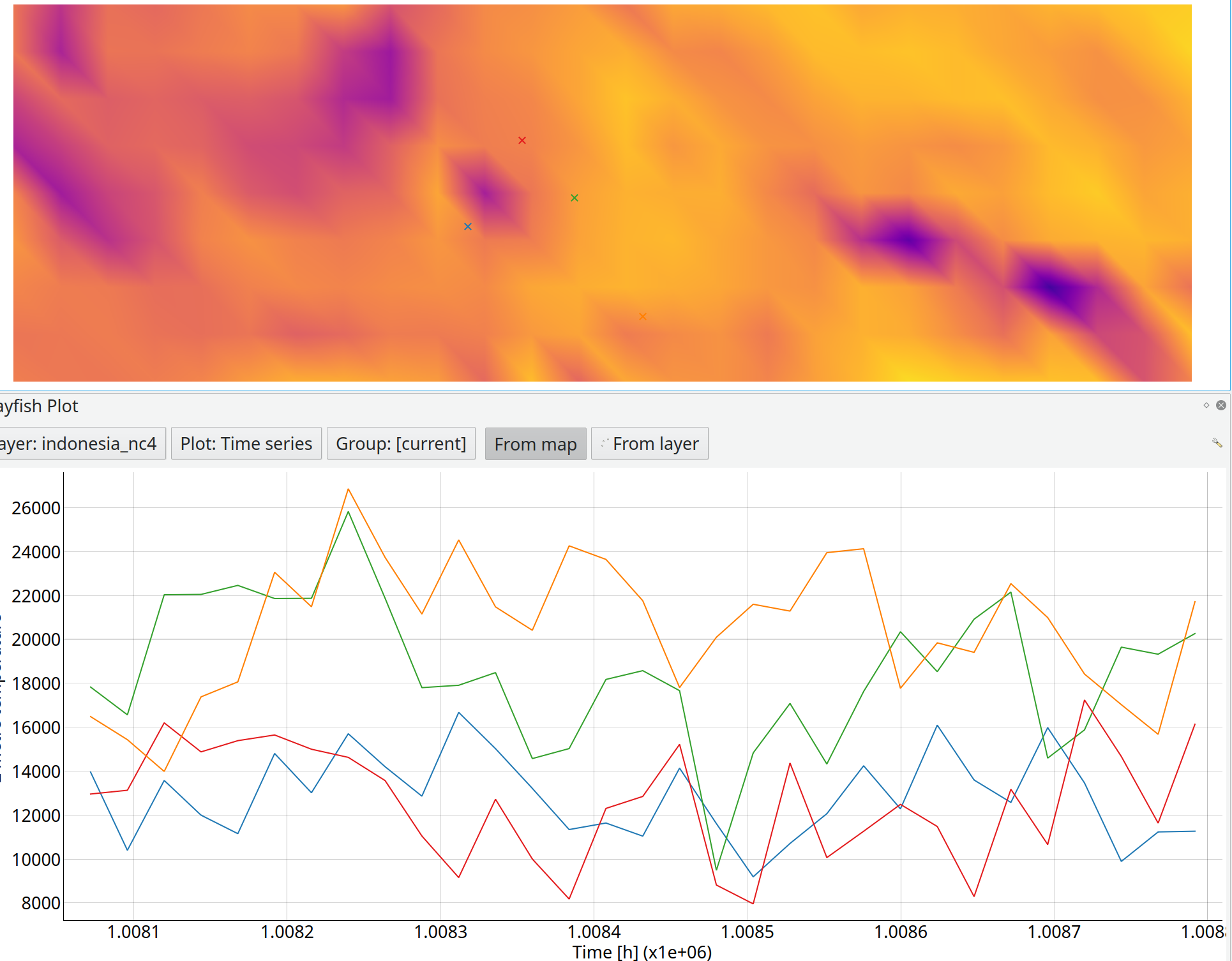
Feature: Mesh layer: add function to identify value on mesh layers
With this API, developers can inspect mesh elements and fetch values spatially and temporally. As an example, you can create time series plot from your mesh layer.
Această funcționalitate a fost dezvoltată de Lutra Consulting
Această funcționalitate a fost dezvoltată de Lutra Consulting
Feature: Mesh layer: allow to choose different vector and scalar dataset
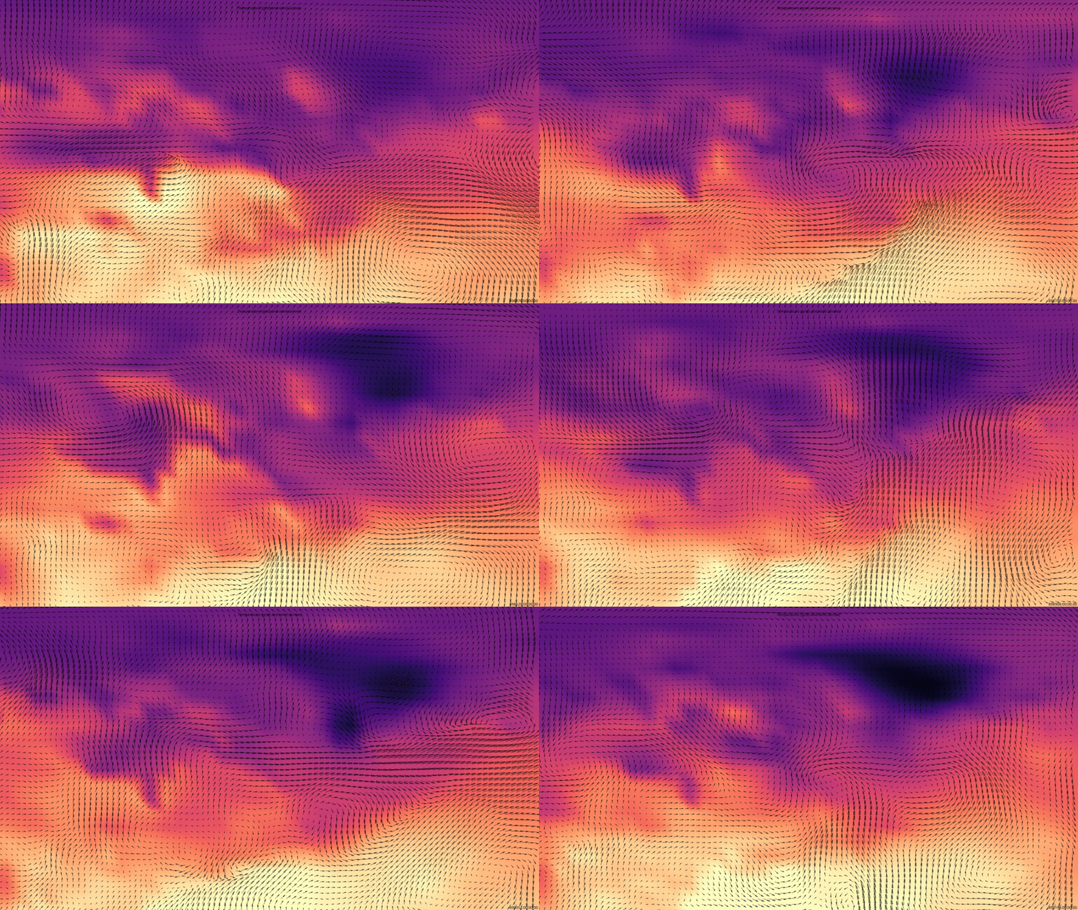
A mesh layer often contains several quantities. For example a netcdf/grib can contain several meteorological quantities. Each quantity can also have multiple components. For example, wind data can contain speed (scalar) and values (grid). With this option, you can overlay scalar and grids from different quantities. In the image below, you can see temperature (grid) and wind (scalar).
Această funcționalitate a fost dezvoltată de Lutra Consulting
Această funcționalitate a fost dezvoltată de Lutra Consulting
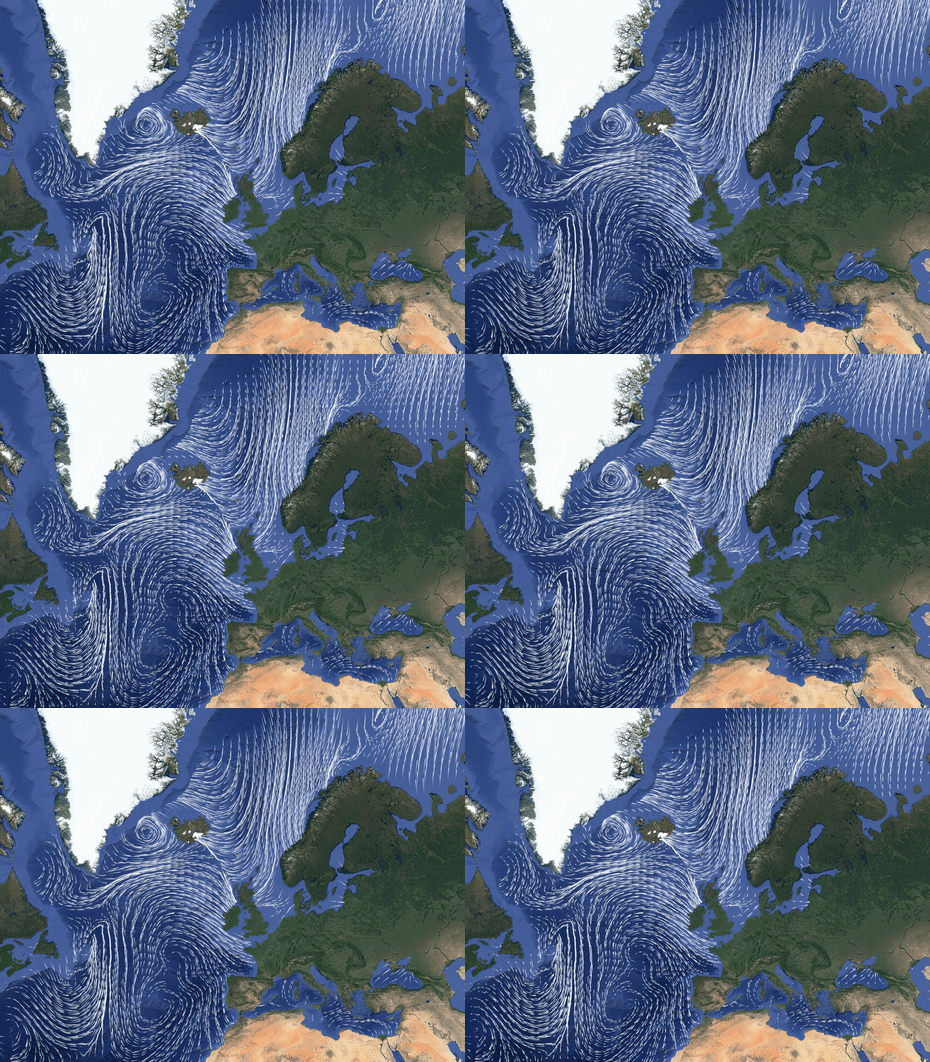
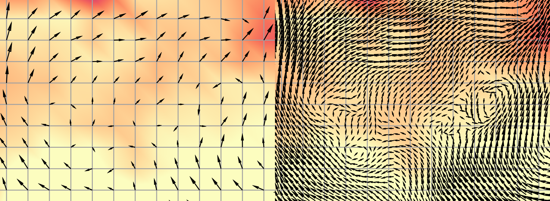
Feature: Mesh layer: allow render vectors/arrows on the user-defined grid
Scalar data are generated usually at the centre/corner of each mesh element. When displaying the scalar data, the arrows might look sparse and often not possible to see the general trend. With this option, arrows can be displayed on a user-defined grid. Extra scalar values will be interpolated on-the-fly and placed on the user-defined grid.
Această funcționalitate a fost dezvoltată de Lutra Consulting
Această funcționalitate a fost dezvoltată de Lutra Consulting
Feature: JSON/JSONB Type support
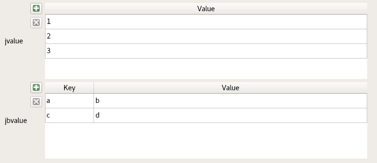
The reading of PostgreSQL JSON types is supported. JSON Data can be displayed in the widgets as „Key/Value” (maps), as „List” (arrays) or as text.
Această funcționalitate a fost finanțată de Kanton Solothurn
Această funcționalitate a fost dezvoltată de David Signer (OPENGIS.ch)
Feature: ESRI Token Authentication support
Support has been added to QGIS» Authentication system for ESRI’s temporary token based authentication. This allows for connection to ArcGIS Feature and Map Servers via an allocated temporary token.
Această funcționalitate a fost dezvoltată de Nyall Dawson (North Road)
Feature: SQL Server - Invalid geometry handling
Recent versions of QGIS have switched to a safer approach to reading SQL Server layers, which automatically checks for geometry validity and repairs geometries when needed. This workaround is required to avoid issues with the design of SQL Server’s geometry handling, where encountering any rows with invalid geometries can silently abort a request without returning all the features from a layer. Unfortunately, the workaround comes at a significant performance cost.
In QGIS 3.4 a new setting was added to allow users to manually turn off QGIS» SQL Server invalid geometry handling. Turning on the „Skip invalid geometry handling” setting under a SQL Server connection’s properties causes QGIS to skip all the expensive geometry validation processing, but firmly places the responsibility for ensuring that all features on the database have valid geometries back upon the user/database administrator. This is a „use at your own risk” setting. Improperly enabling this option can lead to missing features and data loss.
Această funcționalitate a fost dezvoltată de Nyall Dawson (North Road)
QGIS Server
Feature: Server Cache can be manage by plugins
By default, QGIS Server only caches WMS GetCapabilities document in memory. With WMTS implementation, it is necessary to have a way to cache tiles. But the cache manager has not been developed to only cache tiles.
The cache manager plugin can be used to cache:
WMS, WFS, WCS, WMTS GetCapabilities documents
WFS DescribeFeatureType documents
WCS DescribeCoverage documents
WMTS GetTile images
WMS GetLegendGraphic images
Here is a python cache manager class, which do not verify if the QGIS project has changed:
class PyServerCache(QgsServerCacheFilter):

    """ Used to have cache control """

    def __init__(self, server_iface):
        super(QgsServerCacheFilter, self).__init__(server_iface)

        self._cache_dir = os.path.join(tempfile.gettempdir(), "qgs_server_cache")
        if not os.path.exists(self._cache_dir):
            os.mkdir(self._cache_dir)

        self._tile_cache_dir = os.path.join(self._cache_dir, 'tiles')
        if not os.path.exists(self._tile_cache_dir):
            os.mkdir(self._tile_cache_dir)

    def getCachedDocument(self, project, request, key):
        m = hashlib.md5()
        paramMap = request.parameters()
        urlParam = "&".join(["%s=%s" % (k, paramMap[k]) for k in paramMap.keys()])
        m.update(urlParam.encode('utf8'))

        if not os.path.exists(os.path.join(self._cache_dir, m.hexdigest() + ".xml")):
            return QByteArray()

        doc = QDomDocument(m.hexdigest() + ".xml")
        with open(os.path.join(self._cache_dir, m.hexdigest() + ".xml"), "r") as f:
            statusOK, errorStr, errorLine, errorColumn = doc.setContent(f.read(), True)
            if not statusOK:
                print("Could not read or find the contents document. Error at line %d, column %d:\n%s" % (errorLine, errorColumn, errorStr))
                return QByteArray()

        return doc.toByteArray()

    def setCachedDocument(self, doc, project, request, key):
        if not doc:
            print("Could not cache None document")
            return False
        m = hashlib.md5()
        paramMap = request.parameters()
        urlParam = "&".join(["%s=%s" % (k, paramMap[k]) for k in paramMap.keys()])
        m.update(urlParam.encode('utf8'))
        with open(os.path.join(self._cache_dir, m.hexdigest() + ".xml"), "w") as f:
            f.write(doc.toString())
        return os.path.exists(os.path.join(self._cache_dir, m.hexdigest() + ".xml"))

    def deleteCachedDocument(self, project, request, key):
        m = hashlib.md5()
        paramMap = request.parameters()
        urlParam = "&".join(["%s=%s" % (k, paramMap[k]) for k in paramMap.keys()])
        m.update(urlParam.encode('utf8'))
        if os.path.exists(os.path.join(self._cache_dir, m.hexdigest() + ".xml")):
            os.remove(os.path.join(self._cache_dir, m.hexdigest() + ".xml"))
        return not os.path.exists(os.path.join(self._cache_dir, m.hexdigest() + ".xml"))

    def deleteCachedDocuments(self, project):
        filelist = [f for f in os.listdir(self._cache_dir) if f.endswith(".xml")]
        for f in filelist:
            os.remove(os.path.join(self._cache_dir, f))
        filelist = [f for f in os.listdir(self._cache_dir) if f.endswith(".xml")]
        return len(filelist) == 0

    def getCachedImage(self, project, request, key):
        m = hashlib.md5()
        paramMap = request.parameters()
        urlParam = "&".join(["%s=%s" % (k, paramMap[k]) for k in paramMap.keys()])
        m.update(urlParam.encode('utf8'))

        if not os.path.exists(os.path.join(self._tile_cache_dir, m.hexdigest() + ".png")):
            return QByteArray()

        img = QImage(m.hexdigest() + ".png")
        with open(os.path.join(self._tile_cache_dir, m.hexdigest() + ".png"), "rb") as f:
            statusOK = img.loadFromData(f.read())
            if not statusOK:
                print("Could not read or find the contents document. Error at line %d, column %d:\n%s" % (errorLine, errorColumn, errorStr))
                return QByteArray()

        ba = QByteArray()
        buff = QBuffer(ba)
        buff.open(QIODevice.WriteOnly)
        img.save(buff, 'PNG')
        return ba

    def setCachedImage(self, img, project, request, key):
        m = hashlib.md5()
        paramMap = request.parameters()
        urlParam = "&".join(["%s=%s" % (k, paramMap[k]) for k in paramMap.keys()])
        m.update(urlParam.encode('utf8'))
        with open(os.path.join(self._tile_cache_dir, m.hexdigest() + ".png"), "wb") as f:
            f.write(img)
        return os.path.exists(os.path.join(self._tile_cache_dir, m.hexdigest() + ".png"))

    def deleteCachedImage(self, project, request, key):
        m = hashlib.md5()
        paramMap = request.parameters()
        urlParam = "&".join(["%s=%s" % (k, paramMap[k]) for k in paramMap.keys()])
        m.update(urlParam.encode('utf8'))
        if os.path.exists(os.path.join(self._tile_cache_dir, m.hexdigest() + ".png")):
            os.remove(os.path.join(self._tile_cache_dir, m.hexdigest() + ".png"))
        return not os.path.exists(os.path.join(self._tile_cache_dir, m.hexdigest() + ".png"))

    def deleteCachedImages(self, project):
        filelist = [f for f in os.listdir(self._tile_cache_dir) if f.endswith(".png")]
        for f in filelist:
            os.remove(os.path.join(self._tile_cache_dir, f))
        filelist = [f for f in os.listdir(self._tile_cache_dir) if f.endswith(".png")]
        return len(filelist) == 0
And the way to add it to the QGIS Server cache manager.
servercache = PyServerCache(server_iface) server_iface.registerServerCache(servercache, 100)
Această funcționalitate a fost finanțată de Ifremer
Această funcționalitate a fost dezvoltată de 3Liz
Feature: WMTS 1.0.0 support
QGIS Server 3.4 supports WMTS 1.0.0 OGC standard.
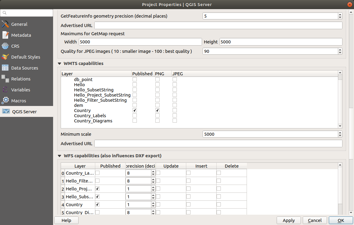
In QGIS project properties, the user can define:
which part of the project (all the project, layer groups or layers) has to be published through WMTS standard
the min scale of the tiles
QGIS Server reuse the CRS defined in the WMS for WMTS.
To manage the tile cache, a QGIS Server plugin with a QgsServerCacheFilter class has to be installed and loaded by QGIS Server.
Această funcționalitate a fost finanțată de Ifremer
Această funcționalitate a fost dezvoltată de 3Liz
Feature: Add ability to define min. scale for WMTS
Această funcționalitate a fost finanțată de https://github.com/rldhont
Această funcționalitate a fost finanțată de https://github.com/rldhont
Feature: Support QGIS Server logs to stderr
It’s now possible to configure QGIS Server to make it write its logs to stderr. This is done by setting the QGIS_SERVER_LOG_FILE env var to the special value „stderr”.
Această funcționalitate a fost dezvoltată de OSLANDIA
Această funcționalitate a fost finanțată de Eric Lemoine
Plugin-uri
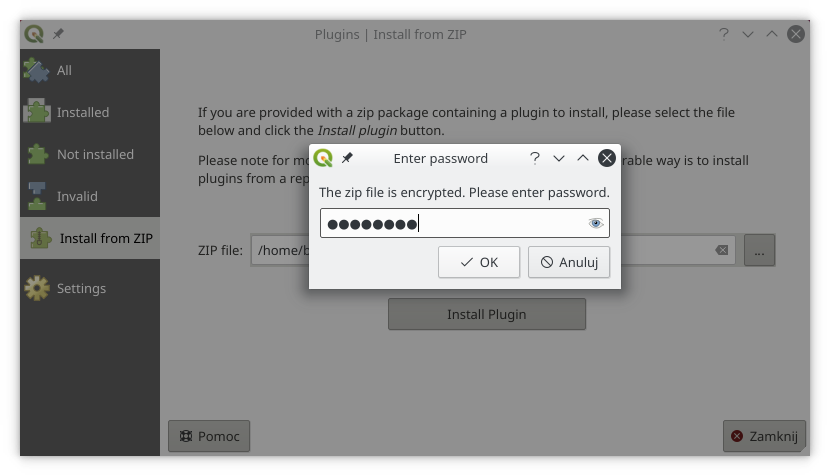
Feature: Support for encrypted zips in the Plugin Manager
Plugin Manager is now able to install plugins from local zip files even if encrypted.
Această funcționalitate a fost finanțată de Borys Jurgiel
Această funcționalitate a fost finanțată de Borys Jurgiel
Feature: Offline Editing GeoPackage
With the offline editing functionality it is possible to select whether the export should create a SpatiaLite or a GeoPackage file for offline usage.
Această funcționalitate a fost finanțată de Oester Messtechnik
Această funcționalitate a fost dezvoltată de David Signer (OPENGIS.ch)
Programabilitate
Feature: QgsSpatialIndexKDBush
A very fast static spatial index for 2D points based on a flat KD-tree, using https://github.com/mourner/kdbush.hpp
Compared to QgsSpatialIndex, this index: - supports single point features only (no multipoints) - is static (features cannot be added or removed from the index after construction) - is much faster! - supports true „distance based” searches, i.e. return all points within a radius from a search point
Această funcționalitate a fost finanțată de North Road
Această funcționalitate a fost dezvoltată de Nyall Dawson (North Road)
Feature: QgsRasterDataProvider::sample method for efficient sampling of rasters at a given point
This is an alternative to the QgsRasterDataProvider::identify method, which is less
efficient but more powerful
Această funcționalitate a fost finanțată de North Road
Această funcționalitate a fost dezvoltată de Nyall Dawson (North Road)
Feature: New geometry API call to return a curve substring
New PyQGIS API has been added to make it easy to retrieve a substring from a LineString/Curve geometry:
QgsCurve::curveSubstring - Returns a new curve representing a substring of a curve, from a start distance and end distance.
If z or m values are present, the output z and m will be interpolated using the existing vertices» z or m values. The method also handles curved geometries without loss or segmentation.
Această funcționalitate a fost finanțată de North Road
Această funcționalitate a fost dezvoltată de Nyall Dawson (North Road)
Feature: sip Module API Changes
Due to upstream changes within the PyQt/sip library, the recommended way to import this module has changed in QGIS 3.4. For maximum portability, instead of directly calling:
import sip
plugins should instead use:
from qgis.PyQt import sip
Using this newer style import will ensure that the code works correct across all platforms and remains functional in future QGIS versions.
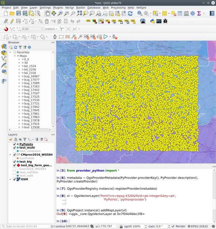
Feature: Python vector data providers
Development of the API, a sample provider and tests allowing the creation of vector data provider in pure python.
Această funcționalitate a fost finanțată de Good will
Această funcționalitate a fost dezvoltată de Alessandro Pasotti
Caracteristici 3D
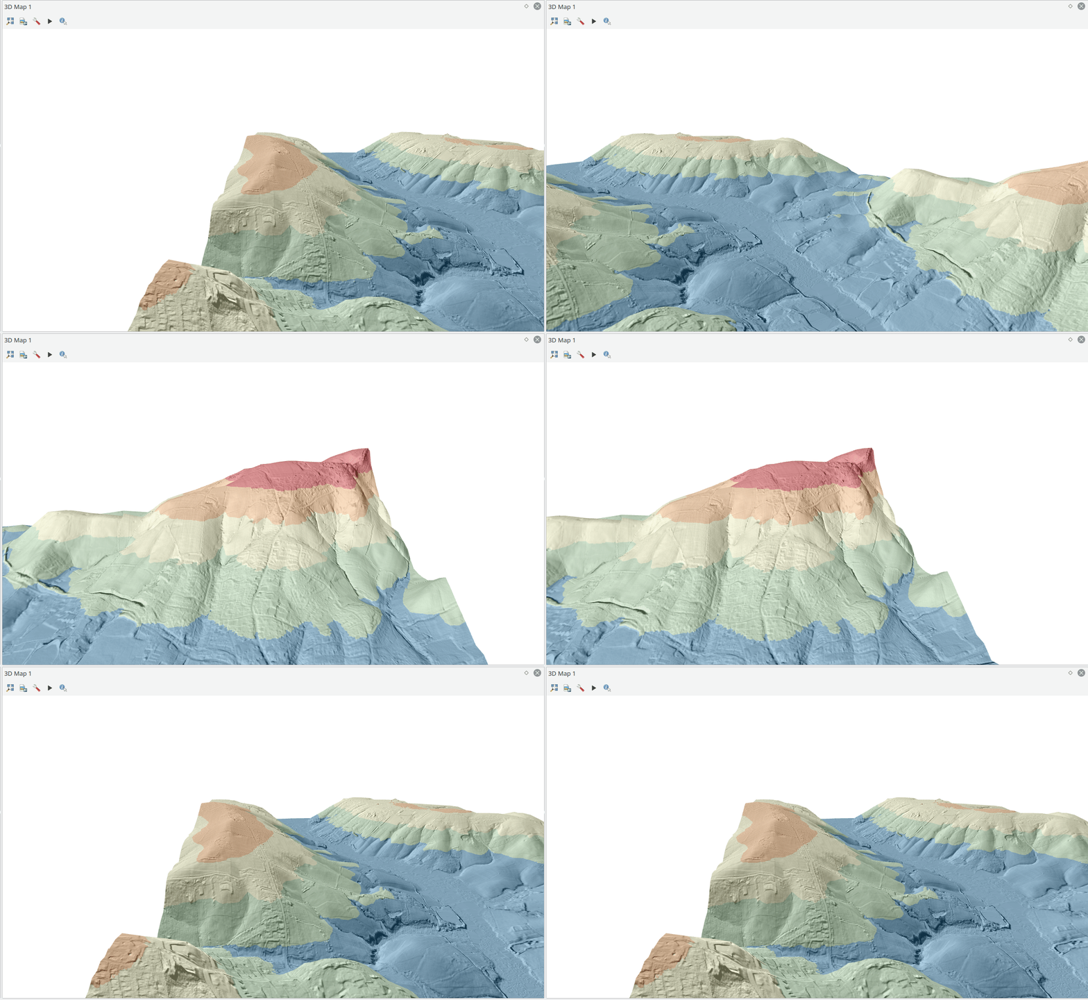
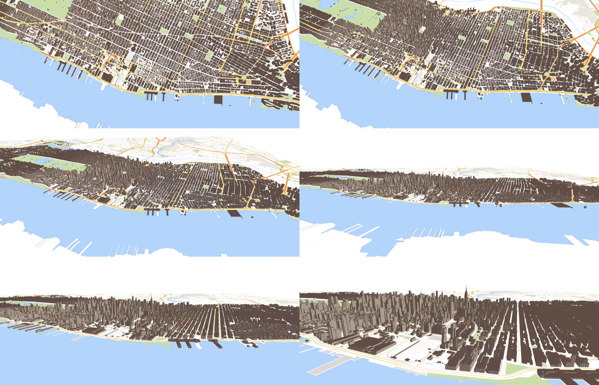
Feature: Animation
You can create an animation based on a set of keyframes - camera positions at particular times. QGIS 3D then interpolates the camera positions/rotations in between the keyframes.
To create the keyframes, first set the scene for your map, by rotating, zooming or moving the camera. Then assign a time to the frame. There are several methods for interpolations between keyframes.
Această funcționalitate a fost finanțată de Comunitatea QGIS community printr-o campanie de finanțare
Această funcționalitate a fost dezvoltată de Martian Dobias (Lutra Consulting)
Feature: Simple rendering of 3D linestrings
This mode of 3D line rendering will use OpenGL line rendering instead of buffering lines into polygons and rendering them as meshes.
The advantage is that the 3D lines do not loose their Z coordinate which is the case currently with „ordinary” 3D rendering after buffering.
The disadvantage is that the lines cannot be wide (supported in Qt3D only since 5.10, but even then their rendering won’t have nice joins/caps) and only ambient color is used from the material.
Această funcționalitate a fost dezvoltată de Lutra Consulting
Această funcționalitate a fost dezvoltată de Martin Dobias (Lutra Consulting)
Feature: Identification map tool for 3D views
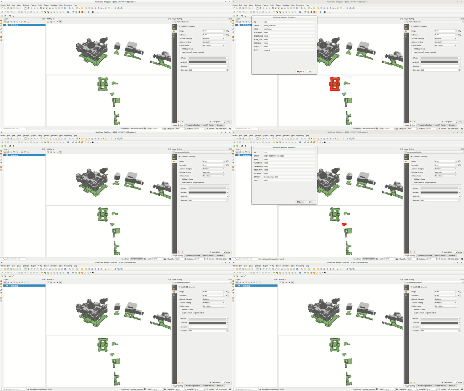
A new Identify Tool was introduced to 3D map. Using this tool, you can inspect features from the 3D scene.
Această funcționalitate a fost dezvoltată de Department of Environment, Land and Infrastructure Engineering (DIATI)
Această funcționalitate a fost dezvoltată de Martin Dobias (Lutra Consulting) and Faunalia
Feature: Experimental Python API
Some classes from QGIS 3D have been made available for Python developers. It is now possible to query or change 3D renderers of map layers and read/write properties of contained 3D symbols such as material colors. Please note that for now the API is considered as experimental, so it may change in future 3.x releases.
Această funcționalitate a fost dezvoltată de Lutra Consulting
Această funcționalitate a fost dezvoltată de Martin Dobias (Lutra Consulting)
