Histórico de alterações do QGIS 2.18

Release date: 2016-10-21
Esse é o último lançamento da série 2.x. A versão de longa duração (LTR) atual permanece sendo a versão 2.14.x. Esta versão fornece melhorias incrementais em relação à nossa versão anterior. A maior parte das atividades estão atualmente focadas no desenvolvimento do QGIS 3.0, que é a nova geração do QGIS com lançamento planejado para o final do primeiro trimestre de 2017.
Agradecimentos
, Nós gostaríamos de agradecer aos desenvolvedores, aos responsáveis pela documentação e pelos testes e a todos que doaram seu tempo e esforço (ou financiaram pessoas para fazer isso). Da comunidade QGIS nós esperamos que você goste deste lançamento! Se você desejar doar seu tempo, dinheiro ou se envolver para fazer o QGIS ainda mais incrível, por favor dê uma olhada em qgis.org e dê uma mão!
O QGIS é apoiado por doadores e patrocinadores. Uma lista atual de doadores que contribuíram com grandes e pequenas contribuições financeiras para o projeto pode ser encontrada em nossa donors list. Se você desejar se tornar um patrocinador oficial do projeto, por favor visite our sponsorship page para mais detalhes. O patrocínio ao QGIS nos ajuda a financiar nossas seis reuniões de desenvolvedores mensais, a manter a infraestrutura do projeto e financiar correções de erros. Uma lista completa de nossos atuais patrocinadores é fornecida abaixo - nosso enorme muito obrigado a todos os nossos patrocinadores!
QGIS é um software livre e você está sob nenhuma obrigação de pagar nada para usá-lo - na verdade, queremos encorajar as pessoas a usá-lo, independentemente da sua situação financeira ou social - nós acreditamos que capacitar as pessoas com ferramentas de tomada de decisão espaciais resulta em uma sociedade melhor para o futuro de toda a humanidade.
Patrocinadores da versão 2.18.0 do QGIS
Anualmentre também recebemos apoio de várias organizações que valorizam o trabalho que fazemos e que gostariam de facilitar o esforço sustentado de desenvolvimento que vai para o projeto. Estes patrocinadores estão listados abaixo com o nosso agradecimento!


|
|
|
|


|
|
|
|
|
|
|
|
|
|
|
|
|
|
|
|
|
SOLTIG (Soluciones en Tecnologías de Información Geográfica) |
|
|
|
|
|
|
|
|
|
|
|
|


Geral
Recurso: Links automáticos em identificar resultados
Todos os links `` http`` ou mailto` dentro de valores de atributo agora serão automaticamente convertidos em links clicáveis dentro do painel de resultados de identificação.
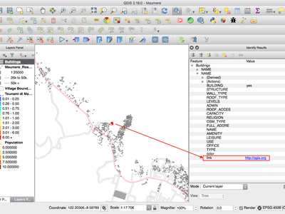
Essa funcionalidade foi desenvolvida por Sandro Mani (Sourcepole)
Recurso: Roda do mouse sobre controles deslizantes de cor
No QGIS 2.18, agora você pode rolar a roda do mouse sobre qualquer um dos controles deslizantes dentro da caixa de diálogo do selecionador de cores para incrementar o valor em pequenas quantidades. Este é um atalho acessível para ajustes pequenos aos componentes da cor.
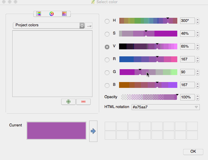
Este recurso foi desenvolvido por Nyall Dawson (North Road)
Este recurso foi desenvolvido por Nyall Dawson (North Road)
Recurso: Adicionar esquemas de cores personalizados ao botão de cores no menu suspenso.
QGIS 2.18 adds the ability for users to set whether a user created color scheme should show up in the color button drop-down menus. This setting is controlled through the color picker dialog, on the lists tab. Just add a new color scheme, then from the scheme menu tick the new “show in buttons” option. It’s a handy shortcut if you have sets of common palettes and want them to be instantly available through the color menu.
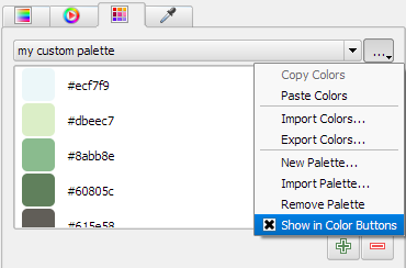
Este recurso foi financiado pela North Road
Este recurso foi desenvolvido por Nyall Dawson (North Road)
Simbologia
Recurso: selecionador de cores agora é incorporado no painel de estilo de camada
In QGIS 2.18 clicking a color button inside the layer style panel causes the color picker dialog to be opened inside the style panel itself rather than as a separate dialog. This allows for interactive modification of colors with immediate preview of the result.
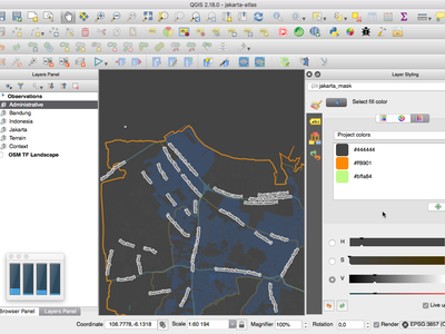
Este recurso foi financiado pela North Road
Este recurso foi desenvolvido por Nyall Dawson (North Road)
Rotulação
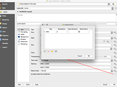
Recurso: Suporte de lista de substituição para rotulagem
Adds the ability to specify a list of text substitutes to make which apply to label text. Eg abbrevating street types.
Os usuários podem exportar e importar listas de substitutos para facilitar a reutilização e o compartilhamento.
Este recurso foi financiado pela North Road
Este recurso foi desenvolvido por Nyall Dawson (North Road)
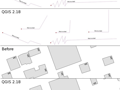
Recurso: Algoritmo melhorado de posicionamento de rótulo de linha
The parallel labeling mode for line layers has been greatly improved, with a new algorithm which avoids placing labels over jagged parts of the feature geometries.
Este recurso foi financiado por Andreas Neumann
Este recurso foi desenvolvido por Nyall Dawson (North Road)
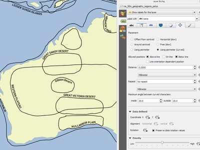
Recurso: Rotular polígonos usando etiquetas curvas ao longo do perímetro
Isso adiciona um novo modo para rotular polígonos onde o perímetro do polígono é rotulado usando rótulos curvados.
Este recurso foi financiado pela North Road
Este recurso foi desenvolvido por Nyall Dawson (North Road)
Renderização
Recurso: visualização de raster tiles (WMTS e camadas XYZ)
In previous versions of QGIS, users had to wait until download of all tiles of a layer has finished in order to view the resulting map. This has now been fixed and the tiles show up in map canvas immediately as they get downloaded, improving the user experience by greatly lowering the time until something is shown. Moreover, previously downloaded tiles from lower or higher resolutions may be used for the preview functionality in the areas where the tiles with correct resolution have not been downloaded yet.
Este recurso foi financiado por Land Information New Zealand
Este recurso foi desenvolvido por Martin Dobias (Lutra Consulting)
Recurso: Cancelar a renderização de rasters (WMS, WMTS, WCS e camadas XYZ)
This enhancement improves user experience when working with raster layers coming from remote servers. Previously one would need to wait until downloads are fully complete in order to be able to zoom or pan the map again, because the user interface would stay frozen in the meanwhile. This is now fixed by the fact that the rendering of raster layers can be cancelled any time.
Este recurso foi financiado por Land Information New Zealand
Este recurso foi desenvolvido por Martin Dobias (Lutra Consulting)
Gerenciamento de dados
Feature: Add flag to only copy selected features
The offline editing plugins is a default plugin that ships with QGIS and allows you to offline a remote dataset (e.g. from a database), edit it in the field, and then resynchonise it when you get back to your office. This extends the offline editing possibilities to only work on subset of large layers.
Este recurso foi financiado por DB Fahrwegdienste GmbH
Esta funcionalidade foi desenvolvida por Matthias Kuhn (OPENGIS.ch)
Formulários e Widgets
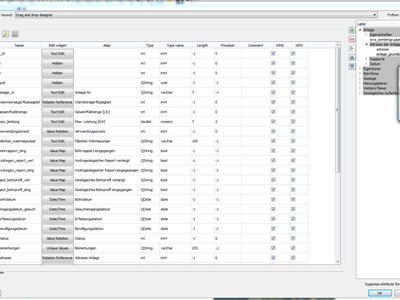
Recurso: Permitir rótulos de controle para ferramentas de edições individuais
Allow controlling labels for individual edit widgets in a form. In the drag and drop designer, a double click on an item will allow controlling if the label should be shown for each item individually.
In addition it is possible to configure if the link/unlink buttons are shown in relation reference widget, which is useful to hide in 1:n relations where a child can’t exist without its parents.
Este recurso foi financiado por Kanton Zug, GIS-Fachstelle
Esta funcionalidade foi desenvolvida por Matthias Kuhn (OPENGIS.ch)
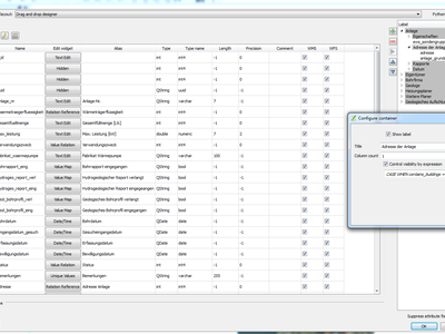
Feature: Conditional visibility for tabs and group boxes
This adds a new configuration option to conditionally show or hide tabs and groupboxes in drag and drop designer forms.
Configuration is done via a double click in the designer tree in the fields configuration interface.
An expression can be entered to control the visibility. The expression will be re-evaluated everytime values in the form change and the tab or groupbox shown/hidden accordingly.
Esta funcionalidade foi desenvolvida por Matthias Kuhn (OPENGIS.ch)
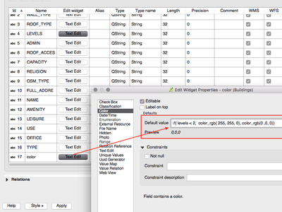
Feature: Client side default field values
Allows an expression to be set for a vector layer field which is used to evaluate a default value for this field. Default value expressions can utilise properties of the feature which exist at the time of calling, such as digitized geometries. Expression variables can also be used in default value expressions, making it easy to eg insert a user’s name, the current datetime, project path, etc.
Este recurso foi financiado por DB Fahrwegdienste GmbH
Este recurso foi desenvolvido por Nyall Dawson (North Road)
Compositor de impressão
Recurso: Setas orientadas ao Norte Verdadeiro
QGIS 2.18 adds support for orienting north arrows in the composer to True North. Previously all arrows were aligned to grid north, which is unsuitable for polar regions or non-north up projections (such as some South African projection systems). Now, you can choose to orient arrows to either grid north or true north. There’s also an optional offset angle, which can be used to specify a grid convergence to make your arrows orient to magnetic north!

Este recurso foi financiado por Norwegian Polar Institute’s Quantarctica project
Este recurso foi desenvolvido por Nyall Dawson (North Road)
Processamento
Recurso: Algoritimo Ponto dentro da superfície
This new algorithm is similar to the centroids algorithm, but where a centroid may fall outside its corresponding feature the ‘Point on surface’ algorithm is guaranteed to create a point which is inside the corresponding polygon feature (or touching the corresponding line feature for line layers).
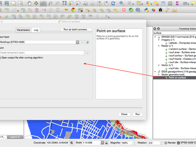
Este recurso foi financiado pela North Road
Este recurso foi desenvolvido por Nyall Dawson (North Road)
Recurso: Processamento do algoritmo dissolver agora aceita vários campos
The dissolve algorithm now allows you to dissolve based on more than one field value. In previous QGIS versions a dissolve could only group features by a single field value.
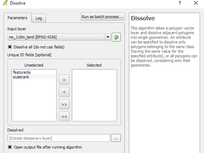
Este recurso foi financiado pela North Road
Este recurso foi desenvolvido por Nyall Dawson (North Road)
Recurso: Processamento otimizado do algoritimo Cortar
O algoritmo de processamento de corte foi otimizado para cenários de uso comum, resultando em acelerações dramáticas para operações de recorte. Por exemplo:
** Cortando uma camada de estradas com 1 milhão de linhas contra 2 polígonos **
** Cortar uma camada de endereço de 5 milhões de pontos contra 2 polígonos **
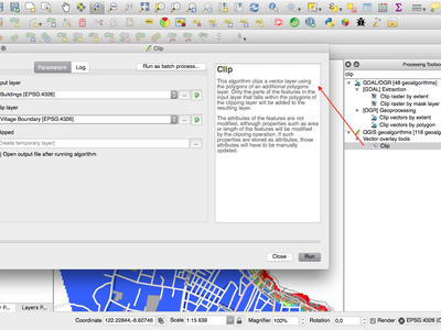
Este recurso foi financiado pela North Road
Este recurso foi desenvolvido por Nyall Dawson (North Road)
Recurso: Algoritmo de caixas de limite
Este novo algoritmo calcula a caixa delimitadora (envelope) de cada feição na camada de entrada.
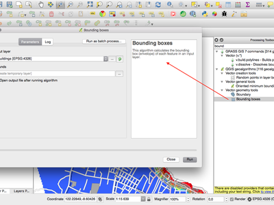
Este recurso foi financiado pela North Road
Este recurso foi desenvolvido por Nyall Dawson (North Road)
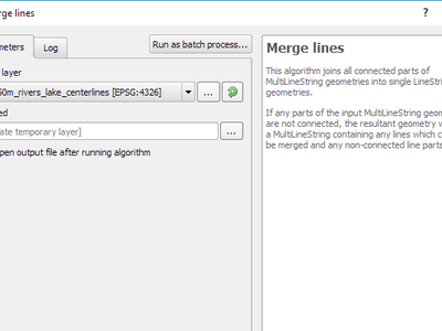
Recurso: Algoritmo para combinar linhas conectadas
This algorithm joins all the connected parts of MultiLineString geometries into single LineString geometries. If any parts of the input MultiLineString geometries are not connected, the resultant geometry will be a MultiLineString containing any lines which could be merged and any non-connected line parts.
Este recurso foi financiado pela North Road
Este recurso foi desenvolvido por Nyall Dawson (North Road)
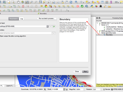
Recurso: Algoritmo de limite de geometria
This new algorithm returns the closure of the combinatorial boundary of the input geometries (ie the topological boundary of the geometry). For instance, a polygon geometry will have a boundary consisting of the linestrings for each ring in the polygon, and a line geometry will have a boundary consisting of the start and end points of the line. This algorithm is only valid for polygon or line layers.
Este recurso foi financiado pela North Road
Este recurso foi desenvolvido por Nyall Dawson (North Road)
Provedores de dados
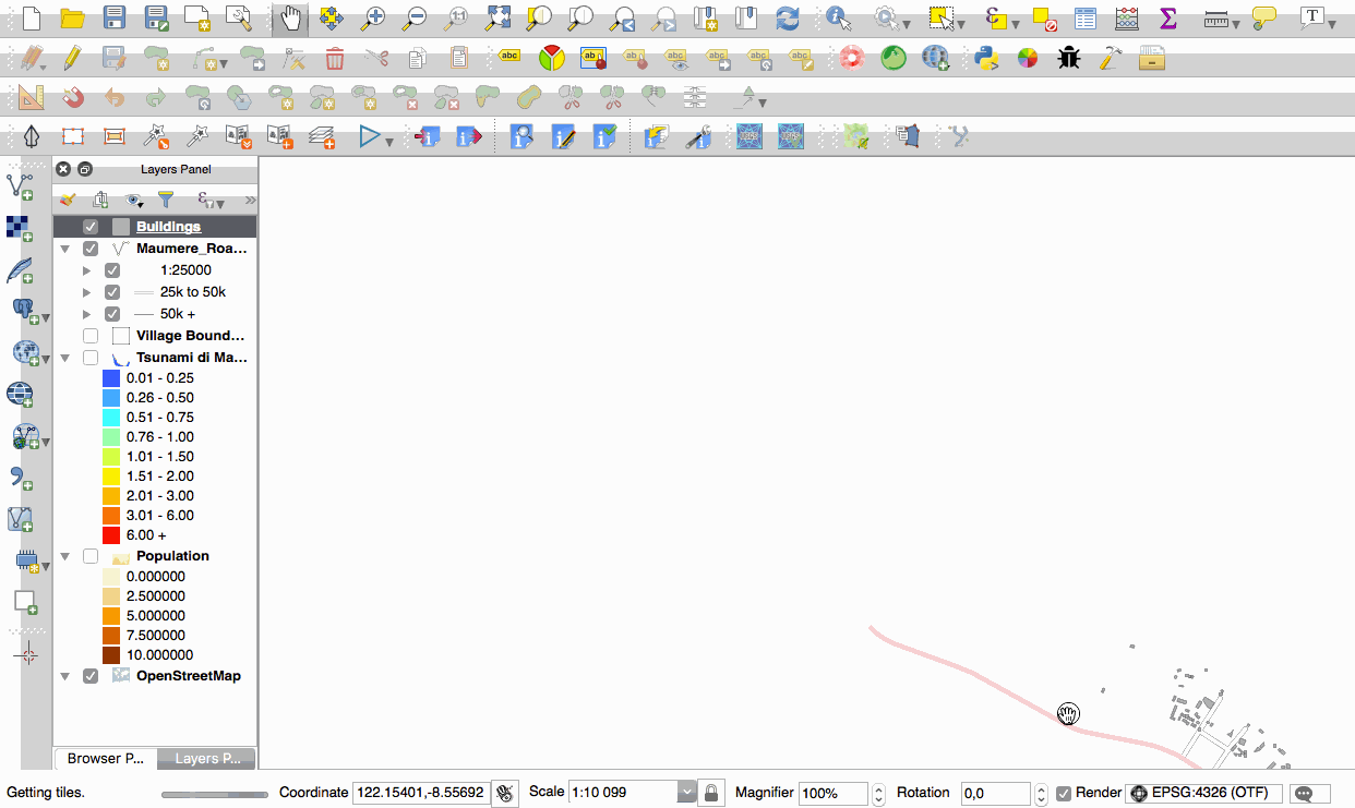
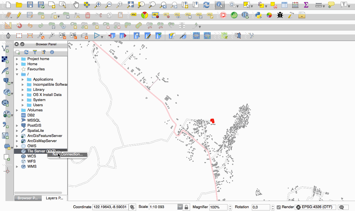
Feature: Native support of XYZ tile layers
Raster tiles in XYZ format are now natively supported within WMS data providers, allowing users to display basemaps from other sources without requiring third-party plugins like QuickMapServices or OpenLayers anymore.
To add connections to XYZ layers, just open browser dock widget, look for item called “Tile Server (XYZ)” and right click it to get a popup menu with “New connection” action. You will be asked for URL, in which {x}, {y}, {z} will be replaced by the actual tile numbers according to the current map view. For example, to add OpenStreetMap base map, one may use this URL:
http://c.tile.openstreetmap.org/{z}/{x}/{y}.png
The data provider also supports encoding of XYZ tile numbers into “quadkeys” used by Bing. Simply use {q} instead of {x}, {y} and {z} in the URL.
Esse recurso foi financiado por Lutra Consulting
Este recurso foi desenvolvido por Martin Dobias (Lutra Consulting)
QGIS Server
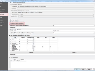
Feição: Possibilidade de segmentar informações de geometria da feição em servidor
Necessary for geometries that contain curves (CircularArc, CompoundCurve, CurvePolygon), but the web client (e.g. QGIS Web Client) can’t handle the display of these geometry types.
This feature can be enabled in the “OWS server” tab in the “Project Properties” dialogue.
Este recurso foi financiado por Andreas Neumann
Essa funcionalidade foi desenvolvida por Marco Hugentobler (Sourcepole)
Complementos
Feature: DB Manager: Add the ability to update SQL Layer
With this feature the user can update the layer datasource if it’s based on an SQL request.
Este recurso foi financiado por Ifremer
Este recurso foi desenvolvido por 3Liz
Programação
Feature: Expose GEOS linear referencing function to QgsGeometry
A new function QgsGeometry::lineLocatePoint() has been added for retrieving the distance along a linestring to the nearest position on the linestring to a given point.
Este recurso foi financiado pela North Road
Este recurso foi desenvolvido por Nyall Dawson (North Road)
Funcionalidade: Novas classes PyGIS no 2.18
Novas classes do núcleo
QgsAnnotation - an interface for annotation items which are drawn over a map
QgsFeedback - a base class for feedback objects to be used for cancellation of something running in a worker thread
QgsOptionalExpression - an expression with an additional enabled flag
New GUI classes, Reusable widgets
QgsExpressionLineEdit - includes a line edit for entering expressions together with a button to open the expression creation dialog. This widget is designed for use in contexts where no layer fields are available for use in an expression and space is constrained.
QgsTabWidget - similar to QTabWidget but with additional methods to temporarily hide/show tabs
Recurso: Novas funções de expressão
QGIS 2.18 adds several new expression functions, including functions for angle/distance interpolation.
line_merge: merges a MultiLineString geometry into connected LineStringsboundary: returns a geometry’s topological boundary, ie for polygons this is a MultiLineString representing the polygon’s ringsangle_at_vertex: returns the average (bisector) angle to a geometry at a specified vertex indexdistance_to_vertex: returns distance along geometry to a specified vertex indexline_interpolate_angle: calculates the angle parallel to a geometry at the specified distance along the geometryline_interpolate_point: returns a point on line at distanceline_locate_point: returns distance along line to nearest line location closest to specified point
Este recurso foi financiado por Andreas Neumann
Este recurso foi desenvolvido por Nyall Dawson (North Road)